
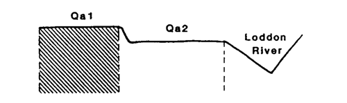
Marong map unit Qa1
Back to: A Land Capability Study of the Rural City of Marong
| Map Unit: | Quaternary alluvium, terrace (Loddon River upper) | Map Unit Symbol: | Qa1 |
| % of Study Area: | 0.1 |
General Description:
A narrow terrace found intermittently along the Loddon River mainly around Newbridge township. The associated soils are red duplex with brown silty clay loam top soils grading into reddish brown fine sandy clay loams and then reddish brown medium clays. The sandy parent material is encountered at less than one meter. A minor variation in the soil type is an increase in fine sand content throughout the profile. A narrow sandy ridge formed by overbank stream flow occurs within the unit at Newbridge.
Site characteristics:
| Parent material age: | Quaternary | Depth seasonal watertable: | > 2.0 m |
| Lithology: | Alluvium | Potential recharge to groundwater: | Moderate |
| Landform Pattern: | Alluvial plain | Flooding risk: | Low |
| Element: | Terrace | Drainage: | Well drained |
| Slope common: | 0 % | Depth to hardrock: | > 1.5 m |
| Slope range: | 0 - 1% | ||
| Rock outcrop: | 0 % |
Major vegetation: Yellow Box, Red Gum, Round-leaf Wattle, Wallaby Grass, Capeweed, introduced grasses
Present land use: Grazing (major), residential (minor)
| Land degradation: | Water erosion | Wind erosion | Salting | Acidification | |
Sheet/rill | Gully | ||||
| Susceptibility | Low | Low | Low | Low | Moderate |
| Incidence | Low | Low | Nil | Low | Moderate |
Soil profile characteristics:
| Permeability (measured - average, range): | 90, 40-150 mm/day |
| Permeability (estimated): | |
| Available water capacity: | 278 mm H2O |
| Linear shrinkage (B horizon): | 3.9 % |
Soil profile description:
| A1 | 0 -18 cm | Greyish yellow brown (10YR4/2) silty loam, moderate structure, subangular blocky peds 5-10 mm, smooth fabric, moderately firm consistence, high organic matter, pH 5.7. Clear transition to |
| A2 | 18 - 32 cm | Bright reddish brown (5YR5/6) fine sandy loam, weak structure, subangular blocky peds 2-5 mm, smooth fabric, moderately firm consistence, pH 5.7. Clear transition to |
| B | 32 - 85 cm | eddish brown (5YR4/3) light clay, moderate/strong structure, angular blocky peds 5-10 mm, smooth fabric, moderately firm consistence, pH 6.0. Clear transition to |
| C | 85 - 150 + cm | Bright brown (7.5YR5/6) sand, pH 6.5. |
Soil classification:
| Factual Key (Northcote): | Dr 2.21 |
| Australian Soil Classification: | Haplic, Eutrophic, Red, Chromosol; moderate, thick, silty, non-gravelly |
| Unified Soil Group: | ML |
Interpretation of soil analyses*
Horizon | pH | Gravel % | E.C. (salts) | Nutrient Status | P | K | Al | Organic Matter | Dispersibility |
| A1 | 5.4 | < 1 | VL | L | D | S | S | H | M |
| A2 | 5.7 | < 1 | VL | L | S | S | S | L | H |
| B | 6.0 | < 1 | VL | M | S | S | S | L | H |
Land capability assessment
Land Use | Class | Major limiting feature(s)/ landuse |
| Agriculture (CTS values) | C3T1S3 | Moderately dispersible top soil, climate |
| Effluent disposal (septic tanks) | 3 | Moderate permeability |
| Farm dams (earthen) | 5 | Very low suitability of subsoil |
| Building foundations - slab | 2 | Nil |
| Building foundations - stumps/footings | 2 | Nil |
| Secondary roads | 4 | Universal Soil Group |
| Urban residential | 4 | Secondary roads |
| Rural residential | 5 | Farm dams |
The high resolution PDF file provided on this page can be viewed using the free Adobe PDF reader, this software can be installed for free from the Adobe website (external link).
A Land Capability Study of the Rural City of Marong - map unit Qa1 - (PDF - 39.6 KB)
© State of Victoria (Agriculture Victoria) 1996 - .

This work, Victorian Resources Online, is licensed under a Creative Commons Attribution 4.0 licence. You are free to re-use the work under that licence, on the condition that you credit the State of Victoria (Agriculture Victoria) as author, indicate if changes were made and comply with the other licence terms.
The licence does not apply to ‘branding’ or some ‘images or photographs’ that may be owned by third parties. We ask you to seek prior approval to use images using the VRO feedback form. Access to higher quality images can also be provided on request.
This page was last updated on .