
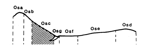
Marong map unit Osc
Back to: A Land Capability Study of the Rural City of Marong
| Map Unit: | Ordovician sediments, moderate slope | Map Unit Symbol: | Osc |
| % of Study Area: | 0.8 |
General Description:
The sedimentary moderate slopes occur on hills of relatively high relief, including the metamorphic aureole. The soils are similar to those on gentler slopes; red duplex with fine sandy loam top soils, sporadically bleached A2 horizons and medium clay subsoils that occasionally contain mottles. Profiles tend to be shallower in comparison. Coarse fragments are common throughout the profile and on the soil surface. On the upper slopes of the metamorphic aureole, the soils become gradational with weakly structured reddish brown loam topsoils and greyish brown fine sandy clay loam subsoils. Coarse fragments are common. These soils are a transition between the red duplex and the shallow loams on the aureole crest.
Site characteristics:
| Parent material age: | Ordovician | Depth seasonal watertable: | > 5 m |
| Lithology: | Sedimentary | Potential recharge to groundwater: | Moderate |
| Landform Pattern: | Rolling hills | Flooding risk: | Nil |
| Element: | Slope | Drainage: | Well drained |
| Slope common: | 12% | Depth to hardrock: | 0.7 m (variable) |
| Slope range: | 10 - 32% | ||
| Rock outcrop: | 2% |
Major vegetation: Grey Box, Red Stringybark, Red Ironbark, Golden Wattle, Hedge Wattle, Wallaby Grass, Cat's Claw Grevillea.
Present land use: Native forest.
| Land degradation: | Water erosion | Wind erosion | Salting | Acidification | |
Sheet/rill | Gully | ||||
| Susceptibility | Very high | Moderate | Low | Low | Moderate |
| Incidence | Moderate | Moderate | Low | Nil | Low |
Soil profile characteristics:
| Permeability (measured - average, range): | 37, 15 - 90 mm/day |
| Permeability (estimated): | - |
| Available water capacity: | 122 mm H2O |
| Linear shrinkage (B horizon): | 14.6% |
Soil profile description:
| A1 | 0-12 cm | Dull reddish brown (5YR4/3) fine sandy loam, weak structure, subangular blocky peds 20-50 mm, smooth fabric, moderately firm consistence, common subangular sedimentary and quartz gravel fragments, moderate organic matter,pH 6.5. Clear transition to |
| A2 | 12-30 cm | Hardsetting orange (5YR6/6) loam, sporadically bleached when dry, weak structure, subangular blocky peds 5-10 mm, smooth fabric, moderately firm consistence, a few organic segregations throughout, many angular coarse sedimentary fragments, pH 5. Clear transition to |
| B2 | 30-60 cm | Dull reddish brown(5YR4/4) medium clay, weak structure, subangular blocky peds 10-20 mm, smooth fabric, very firm consistence, pH 5.5. Gradual transition to |
| B3 | 60-70 cm | Dull reddish brown (5YR4/4) medium clay, moderate structure, subangular blocky peds 5-10 mm, smooth fabric, moderately firm consistence, many subangular sedimentary gravel, pH 10. |
Soil classification:
| Factual Key (Northcote): | Dr 2.33 (major), Gn 4.54 (minor) |
| Australian Soil Classification: | Subnatric, Red, Sodosol; moderate, medium, loamy, gravelly |
| Unified Soil Group: | CH |
Interpretation of soil analyses*
Horizon | pH | Gravel % | E.C. (salts) | Nutrient Status | P | K | Al | Organic Matter | Dispersibility |
| A1 | 6.2 | 2.6 | VL | M | D | S | S | H | L |
| A2 | 4.7** | 3.1 | VL | VL | D | D | T | H | H |
| B2 | 7.3 | 2.9 | M | H | D | S | S | L | VH |
| B3 | 9.0 | 62.9 | H | H | D | S | S | VL | L |
Land capability assessment
Land Use | Class | Major limiting feature(s)/ landuse |
| Agriculture (CTS values) | C3T4S5 | Very susceptible to sheet/rill erosion |
| Effluent disposal (septic tanks) | 4 | Shallow depth to hard rock, moderate slope, slow permeability |
| Farm dams (earthen) | 5 | Shallow depth to hard rock, very low suitability of subsoil, very dispersible subsoil |
| Building foundations -* slab | 4 | Moderate slope |
| Building foundations - stumps/footings | 3 | Moderate slope, moderate risk of slope failure, moderate linear shrinkage, shallow depth to hardrock |
| Secondary roads | 5 | Very dispersible subsoil |
| Urban residential | 5 | Secondary roads |
| Rural residential | 5 | Farm dams, secondary roads |
The high resolution PDF file provided on this page can be viewed using the free Adobe PDF reader, this software can be installed for free from the Adobe website (external link).
A Land Capability Study of the Rural City of Marong - map unit Osc - (PDF - 39 KB)
© State of Victoria (Agriculture Victoria) 1996 - .

This work, Victorian Resources Online, is licensed under a Creative Commons Attribution 4.0 licence. You are free to re-use the work under that licence, on the condition that you credit the State of Victoria (Agriculture Victoria) as author, indicate if changes were made and comply with the other licence terms.
The licence does not apply to ‘branding’ or some ‘images or photographs’ that may be owned by third parties. We ask you to seek prior approval to use images using the VRO feedback form. Access to higher quality images can also be provided on request.
This page was last updated on .