
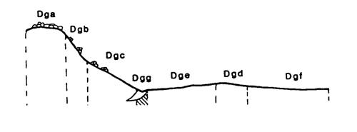
Marong map unit Dgg
Back to: A Land Capability Study of the Rural City of Marong
| Map Unit: | Devonian granodiorite, drainage depression | Map Unit Symbol: | Dgg |
| % of Study Area: | 0.8 |
General Description:
The major and minor drainage lines within this unit contain a mixture of uniform sands with clay and silt lenses and yellow duplex soils. Uniform sands are dominant in the major drainage depressions and have been described below. Yellow duplex soils occur in the minor drainage depressions. Tors occasionally outcrop within this unit.
Site characteristics:
| Parent material age: | Devonian | Depth seasonal watertable: | > 1 0 m |
| Lithology: | Granodiorite | Potential recharge to groundwater: | Very High |
| Landform Pattern: | Undulating / Rolling low hills | Flooding risk: | High |
| Element: | Drainage depression | Drainage: | Moderately well drained |
| Slope common: | 0% | Depth to hardrock: | > 1.50 m |
| Slope range: | 0 - 2% | ||
| Rock outcrop: | > 2% |
Major vegetation: Red Gum, Yellow Box, Buloke, Hedge Wattle, Wallaby Grass
Present land use: Grazing (major) recreation, native forest (minor)
| Land degradation: | Water erosion | Wind erosion | Salting | Acidification | |
Sheet/rill | Gully | ||||
| Susceptibility | Low | High | High | Moderate | Moderate |
| Incidence | Low | Moderate | Low | Moderate | Low |
Soil profile characteristics:
| Permeability (measured - average, range): | 8390 3940 - 12510 mm/day |
| Permeability (estimated): | |
| Available water capacity: | 350 mm H2O |
| Linear shrinkage (B horizon): | 5.9 % |
Soil profile description:
| A | 0-19 cm | Dull yellowish brown (10YR 5/3) loamy sand, apedal, loose consistence, pH 6.0. Clear transition to |
| C | 19-62 cm | Dull yellowish brown (10YR 5/3) sandy loam, apedal, loose consistence, pH 7.0. Gradual transition to |
| 2A | 62-86 cm | Greyish yellow brown (10YR 5/2) sandy loam, a few medium distinct red mottles, weak structure, subangular blocky peds 5-15 mm, rough fabric, moderately weak consistence, pH 7.4. Clear transition to |
| 2B2 | 86-101 cm | Greyish yellow brown (10YR 5/2) light sandy clay loam, common distinct medium sized yellowish brown mottles, structureless, loose consistence, a few subangular fine quartz fragments, pH 7.8. Clear transition to |
| 2B3 | 101-130 + cm | Brownish grey (10YR 5/1) silt loam, a few distinct fine yellowish brown mottles, weak structure, subangular blocky peds 10-20 mm, smooth fabric, moderately firm consistence, pH 7.4 |
Soil classification:
| Factual Key (Northcote): | Uc (major), Dy3.41 (minor) |
| Australian Soil Classification: | Brown, Arenic, Rudosol; very deep, medium, sandy, non-gravelly |
| Unified Soil Group: | SM |
Interpretation of soil analyses*
Horizon | pH | Gravel % | E.C. (salts) | Nutrient Status | P | K | Al | Organic Matter | Dispersibility |
| A | 6.0 | < 1 | VL | VL | D | S | S | L | L |
| C | 7.0 | < 1 | L | VL | D | S | S | L | L |
| 2A | 7.4 | 0.4 | L | VL | D | D | S | L | L |
| 2B2 | 7.8 | 29.7 | VL | L | D | D | S | L | L |
| 2B3 | 7.4 | 2.2 | VL | L | D | S | S | M | H |
Land capability assessment
Land Use | Class | Major limiting feature(s)/ landuse |
| Agriculture (CTS values) | C3T1S5 | High seasonal watertable |
| Effluent disposal (septic tanks) | 5 | High seasonal watertable, high risk of flooding, excessive permeability – risk of polluting groundwater and adjacent streams |
| Farm dams (earthen) | 5 | High seasonal watertable, excessive permeability |
| Building foundations - slab | 5 | High seasonal watertable, high risk of flooding |
| Building foundations - stumps/footings | 5 | High seasonal watertable, high risk of flooding |
| Secondary roads | 5 | High risk of flooding |
| Urban residential | 5 | Secondary roads, building foundations |
| Rural residential | 5 | Farm dams, effluent disposal, secondary roads, building foundations. |
The high resolution PDF file provided on this page can be viewed using the free Adobe PDF reader, this software can be installed for free from the Adobe website (external link).
A Land Capability Study of the Rural City of Marong - map unit Dgg - (PDF - 38 KB)
© State of Victoria (Agriculture Victoria) 1996 - .

This work, Victorian Resources Online, is licensed under a Creative Commons Attribution 4.0 licence. You are free to re-use the work under that licence, on the condition that you credit the State of Victoria (Agriculture Victoria) as author, indicate if changes were made and comply with the other licence terms.
The licence does not apply to ‘branding’ or some ‘images or photographs’ that may be owned by third parties. We ask you to seek prior approval to use images using the VRO feedback form. Access to higher quality images can also be provided on request.
This page was last updated on .