
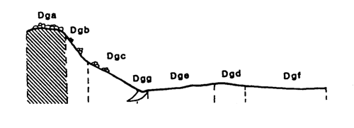
Marong map unit Dga
Back to: A Land Capability Study of the Rural City of Marong
| Map Unit: | Devonian granodiorite, crest | Map Unit Symbol: | Dga |
| % of Study Area: | 0.6 |
General Description:
Crest positions within the rolling low hills of the granodiorite, characterised by large numbers of outcropping tors. The soils are dominantly shallow uniform coarse sands with dark brown sandy loam top soils. Profile depth varies considerably. Small pockets of deeper duplex soils can occur between the tors.
Site characteristics:
| Parent material age: | Devonian | Depth seasonal watertable: | > 10 m |
| Lithology: | Granodiorite | Potential recharge to groundwater: | Very high |
| Landform Pattern: | Undulating/rolling low hills | Flooding risk: | Nil |
| Element: | Crest | Drainage: | Rapidly drained |
| Slope common: | 0% | Depth to hardrock: | 0.4 m (variable) |
| Slope range: | 0 - 2% | ||
| Rock outcrop: | 20 - 40% |
Major vegetation: Long-leaf Box, Yellow Box, Blackwood, Lightwood, Black Wattle, Buloke, Grey Box, Austral Bracken
Present land use: Partially forested, sheep grazing (major), residential (minor)
| Land degradation: | Water erosion | Wind erosion | Salting | Acidification | |
Sheet/rill | Gully | ||||
| Susceptibility | Low | Low | Moderate | Low | Low |
| Incidence | Low | Low | Moderate | nil | Low |
Soil profile characteristics:
| Permeability (measured - average, range): | 20080, 12923 - 29580 mm/day |
| Permeability (estimated): | - |
| Available water capacity: | 64 mm H2O |
| Linear shrinkage (B horizon): | Low (estimate) |
Soil profile description:
| A | 0 - 10 cm | Dark red brown (5YR 3/2) sandy loam, apedal, sandy fabric, loose consistence, high organic matter, pH 5.5 Clear transition to |
| C | 10 - 40 cm | Dull red brown (5YR 4/4) clayey sand, apedal, sandy fabric, loose consistence, a few quartz fragments pH 5.4 |
| 40+ cm | Rock |
Soil classification:
| Factual Key (Northcote): | Uc 1.23 (major) Dy 3.41 (minor) |
| Australian Soil Classification: | Arenic Rudosol; shallow thin loamy, non-gravelly |
| Unified Soil Group: | SM |
Interpretation of soil analyses*
Horizon | pH | Gravel % | E.C. (salts) | Nutrient Status | P | K | Al | Organic Matter | Dispersibility |
| A | 5.5** | 21.2 | VL | L | D | S | T | H | L |
| C | 5.4** | 29.0 | VL | VL | D | S | T | L | L |
Land capability assessment
Land Use | Class | Major limiting feature(s)/ landuse |
| Agriculture (CTS values) | C3T1S5 | Very high gravel/stone/boulder content,shallow depth to hardrock |
| Effluent disposal (septic tanks) | 5 | Shallow depth to hardrock, excessive permeability – risk of polluting groundwater |
| Farm dams (earthen) | 5 | Shallow depth to hardrock, very low suitability of subsoil, excessive permeability |
| Building foundations - slab | 4 | Shallow depth to hardrock |
| Building foundations - stumps/footings | 4 | Shallow depth to hardrock |
| Secondary roads | 4 | Shallow depth to hardrock |
| Urban residential | 4 | Secondary roads, building foundations |
| Rural residential | 5 | Farm dams, effluent disposal |
The high resolution PDF file provided on this page can be viewed using the free Adobe PDF reader, this software can be installed for free from the Adobe website (external link).
A Land Capability Study of the Rural City of Marong - map unit Dga - (PDF - 38.6 KB)
© State of Victoria (Agriculture Victoria) 1996 - .

This work, Victorian Resources Online, is licensed under a Creative Commons Attribution 4.0 licence. You are free to re-use the work under that licence, on the condition that you credit the State of Victoria (Agriculture Victoria) as author, indicate if changes were made and comply with the other licence terms.
The licence does not apply to ‘branding’ or some ‘images or photographs’ that may be owned by third parties. We ask you to seek prior approval to use images using the VRO feedback form. Access to higher quality images can also be provided on request.
This page was last updated on .