
Sodosols
Sodosols have strong texture contrast between A and B horizons. The B horizons are sodic and vary from alkaline to moderately acidic.
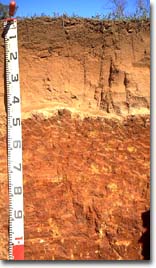 Red Sodosol near Boort. Note the sandy surface horizons overlying the dense medium clay subsoil. The upper subsoil has coarse columnar structure. | Red Sodosols Red Sodosols occupy about half the northern sheet area, mostly on the older alluvial plain and on hillslopes, but also on volcanic plains and lunettes. Older alluvial plains occupy most of the Riverine Plain, and the soils are mainly red Sodosols with carbonates in the subsoil. These are generally referred to as "red brown earths". There is a textural sequence from soils with a high proportion of sand on prior stream levees to clay soils on the floodplains. The lighter soils have higher productivity, both under dryland irrigated farming. The heavier soils are more affected by hard setting surfaces and low hydraulic conductivity. The lower sites often have grey poorly-structured Vertosols. Gentle hillslopes on Palaeozoic sediments have red Sodosols with abundant gravel in the upper horizons. Profiles tend to be shallow, usually less than one metre thick. Land use is mostly grazing and productivity is limited by factors such as low rainfall, poor soil structure, sheet erosion and gully erosion. Dermosols are found on the steeper crests and yellow Sodosols in low sites. Volcanic plains with red Sodosols are limited to the area west of the Cairn Curran Reservoir, associated with Dermosols on the more dissected sites and Vertosols in drainage lines. |
The largest and most frequent lunettes occur in the Tyrrell basin, whilst small isolated examples can be found on the River Murray floodplain. Red Sodosols are the most common, but yellow Sodosols and yellow brown clay Tenosols have also been noted. These clay soils appear little changed from the parent materials, ie. clay pellets blown from the lake floors. Lunettes are often cropped, but sheet and gully erosion are potential problems.
| This map of Sodosols in the North Central region has been developed by Jim Rowan and is based on the Land Systems of Victoria (1:250 000). It shows areas where Sodosols are most likely to occur within the region. Note that other soil types may also occur within these mapped areas (although they are likely to be a more minor component). | 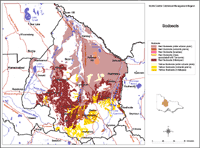 Sodosols North Central Region |
Yellow to yellow-brown Sodosols occur on hillslopes, on volcanic plains and on older alluvial plains. They are used mostly for grazing, the surface horizons being hardsetting and the subsoils having low permeability.
Hillslope yellow Sodosols are widespread on the lower, gentler slopes on Palaeozoic sediments where sheet and gully erosion are problems, and in places tunnel erosion. Tenosols and Dermosols occupy the steeper crests, whilst Vertosols may occur on alluviated valley bottoms.
Volcanic plain yellow Sodosols occupy much of the vast Western Plain, with Vertosols in alluviated valleys. The parent materials of the deep Sodosols may be derived partly from fluviatile and aeolian accessions.
Older alluvial plain yellow Sodosols occupy three small areas to the north of Bendigo, in the Loddon Catchment.
© State of Victoria (Agriculture Victoria) 1996 - .

This work, Victorian Resources Online, is licensed under a Creative Commons Attribution 4.0 licence. You are free to re-use the work under that licence, on the condition that you credit the State of Victoria (Agriculture Victoria) as author, indicate if changes were made and comply with the other licence terms.
The licence does not apply to ‘branding’ or some ‘images or photographs’ that may be owned by third parties. We ask you to seek prior approval to use images using the VRO feedback form. Access to higher quality images can also be provided on request.
This page was last updated on .