
EGW105
Location: Beloka
Australian Soil Classification: Red DERMOSOL
Map Unit: Beloka
Previous Site Name: EG105
General Landscape Description: Undulating low hills
Site Description: Mid to upper slope
Land Use: Grazing on annual pasture
Native Vegetation: Montane riparian woodland
Geology: Colluvium and alluvium derived from Palaeozoic sediments
Soil Profile Morphology:
Surface Soil
| A11 | 0 – 5 cm | Dark brown (7.5YR3/2); silty loam; weak polyhedral structure; gradual change to: | 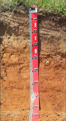 |
| A12 | 5 – 25 cm | Yellowish brown (10YR5/4); fine sandy clay loam; weak polyhedral structure; clear change to: | |
| Subsoil | |||
| B1 | 25 – 45 cm | Strong brown (7.5YR4/6); silty clay; moderate prismatic structure; gradual change to: | |
| B2 | 45 – 75 cm+ | Yellowish red (5YR4/6); silty light to medium clay; moderate prismatic structure. |
Comments:
This soil profile is very similar in appearance to EG203 and is expected to behave similarly.
Soil Profile Described By: David Rees and Grant Boyle, 2000.
© State of Victoria (Agriculture Victoria) 1996 - .

This work, Victorian Resources Online, is licensed under a Creative Commons Attribution 4.0 licence. You are free to re-use the work under that licence, on the condition that you credit the State of Victoria (Agriculture Victoria) as author, indicate if changes were made and comply with the other licence terms.
The licence does not apply to ‘branding’ or some ‘images or photographs’ that may be owned by third parties. We ask you to seek prior approval to use images using the VRO feedback form. Access to higher quality images can also be provided on request.
This page was last updated on .