
EGC204
Location: Benambra (East of township)
Australian Soil Classification: Sodic, Eutrophic, Black CHROMOSOL
Map Unit: Benambra (Component 1)
Previous Site Name: EG204
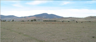
General Landscape Description: Almost level plain
Land Use: Grazing on annual pasture
Native Vegetation: Montane grassland
Geology: Pleistocene to recent alluvial deposits
Soil Profile Morphology:
| Surface soil | 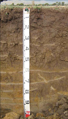 | ||
| A1 | 0 – 15 cm | Very dark greyish brown (10YR3/2); clay loam; moderate coarse (20 – 50 mm) polyhedral structure; firm consistence dry; abrupt change to: | |
| Subsoil | |||
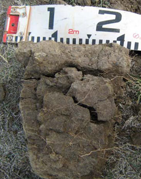
| B21 | 15 – 45 cm | Very dark grey (10YR3/1); medium clay; strong very coarse (> 50 mm) prismatic structure; very firm to strong consistence dry; | |
| B22 | 45 – 80 cm | Brown (10YR5/3); medium clay; strong very coarse (> 50 mm) prismatic to lenticular structure; strong consistence dry; clear change to: | |
| D | 80 – 105+ cm | Yellowish brown (10YR5/6); sandy clay; apedal; strong consistence dry; becoming sandier with depth. |
Key Profile Features:
- Texture contrast between the surface (A1) horizon and subsoil (B21) horizon.
- Strongly structured subsoils.
Soil Profile Characteristics:
- | pH | Salinity | ||
Surface soil (A1 horizon) | Strongly Acid | Very Low | Non-sodic | None |
Subsoil (B21 horizon) | Slightly Acid | Very Low | Non-sodic | Slight1 |
Deeper subsoil (B22) | Slightly Alkaline | Very Low | Sodic | None |
Chemical and Physical Analysis:
Horizon | Horizon Depth (cm) | pH (water) | EC dS/m | Coarse Sand (0.2-2.0 mm) % | Fine Sand (0.02-0.2 mm) % | Silt (0.002-0.02 mm) % | Clay (<0.002 mm) % | Field Capacity % w/w | Wilting Point % w/w |
A1 | 0-15 | 5.3 | 0.09 | 17 | 35 | 18 | 20 | 31.4 | 11.1 |
B21 | 15-45 | 6.1 | <0.05 | 19 | 28.5 | 18 | 30 | 27.5 | 15.0 |
B22 | 45-80 | 7.7 | 0.13 | 22.5 | 31 | 16 | 26 | 26.0 | 14.4 |
Management Considerations
Whole profile
|  |
Soil Profile Described By: Heather Adams, Julieanne Sargant and Ian Sargeant, June 2009.
© State of Victoria (Agriculture Victoria) 1996 - .

This work, Victorian Resources Online, is licensed under a Creative Commons Attribution 4.0 licence. You are free to re-use the work under that licence, on the condition that you credit the State of Victoria (Agriculture Victoria) as author, indicate if changes were made and comply with the other licence terms.
The licence does not apply to ‘branding’ or some ‘images or photographs’ that may be owned by third parties. We ask you to seek prior approval to use images using the VRO feedback form. Access to higher quality images can also be provided on request.
This page was last updated on .