
EGC203
Location: Beloka
Australian Soil Classification: Acidic, Mesotrophic, Red DERMOSOL
Map Unit: Beloka
Previous Site Name: EG203
General Landscape Description: Undulating low hills
Site Description: Simple mid-slope, 3% slope to north
Land Use: Grazing on annual pasture
Native Vegetation: Montane riparian woodland
Geology: Colluvium and alluvium derived from Palaeozoic sediments
Soil Profile Morphology:
| Surface soil | 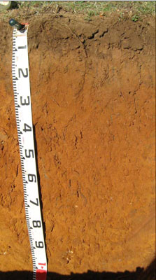 | ||
| A11 | 0 – 12 cm | Dark brown (7.5YR4/4); silty clay loam; moderate very fine (2 – 5 mm) granular structure, weak consistence, dry; clear change to: | |
| A12 | 12 – 25 cm | Strong brown (7.5YR4/6); silty clay loam; moderate very fine (2 – 5 mm) granular structure, weak consistence dry; gradual change to: | |
| Subsoil | |||
| B1 | 25 – 50 cm | Yellowish red (5YR5/6); silty light clay (sub-plastic); weak very fine (2 – 5 mm) granular structure, firm consistence dry; gradual change to: | |
| B21 | 50 – 70 cm | Yellowish red (5YR5/8); silty light clay (sub-plastic); weak fine (5 – 10 mm) polyhedral structure, firm consistence dry; clear change to: | |
| B22 | 70 – 110+ cm | Yellowish red (5YR54/6); silty light clay (subplastic); weak fine (5 – 10 mm) polyhedral structure, firm consistence dry; very few (< 2 %) medium (6 – 20 mm) quartz pebbles |
Key Profile Features:
- Lack of strong texture contrast between the surface (A) horizons and the subsoil (B21) horizon.
- The whole profile has very low amounts of soluble salts.
Soil Profile Characteristics:
- | pH | Salinity | ||
Surface soil (A1 horizon) | Moderately Acid | Very Low | Non-sodic | None |
Subsoil (B1 horizon) | Strongly Acid | Very Low | Non-sodic | None |
Deeper subsoil (70 -110 cm) | Strongly Acid | Very Low | Non-sodic | None |
Chemical and Physical Analysis:
Horizon | Horizon Depth (cm) | pH (water) | pH (CaCl2) | EC dS/m | Organic Carbon % | Total Nitrogen % | Exchangeable Aluminium ppm | Exchangeable Acididty meq/100g | Exchangeable Cations | Coarse Sand (0.2-2.0 mm) % | Fine Sand (0.02-0.2 mm) % | Silt (0.002-0.02 mm) % | Clay (<0.002 mm) % | Field Capacity % w/w | Wilting Point % w/w | |||
Ca | Mg | K | Na | |||||||||||||||
meq/100g | ||||||||||||||||||
A11 | 0-12 | 5.6 | 4.9 | 0.08 | 3.6 | 0.25 | <10 | 8.3 | 4.9 | 0.95 | 0.62 | 0.06 | 20 | 35 | 12 | 26 | 27.7 | 9.5 |
A12 | 12-25 | 5.5 | 4.8 | 0.05 | 1.1 | 0.08 | 15 | 6.3 | 3.1 | 1 | 0.4 | 0.06 | 16 | 37 | 14 | 28 | 22.2 | 7.8 |
B1 | 25-50 | 5.3 | 4.5 | <0.05 | 0.8 | 75 | 11.0 | 3.4 | 2.6 | 0.76 | 0.08 | 11 | 22 | 14 | 49 | 29.3 | 17.0 | |
B21 | 50-70 | 5.4 | 4.6 | <0.05 | 0.62 | 39 | 12.0 | 3.4 | 3.2 | 0.9 | 0.08 | 10 | 18 | 12 | 57 | 34.7 | 21.0 | |
B22 | 70-110 | 5.2 | 4.4 | <0.05 | 0.47 | 170 | 14.0 | 1.9 | 2.4 | 0.74 | 0.1 | 10 | 18 | 13 | 59 | 34.7 | 21.4 | |
Management Considerations
Whole profile
- Plant available water is considered to be moderate for this profile, assuming an effective rooting depth of 90 cm, although most were within 30 cm of the surface in the soil pit.
Surface (A) horizons
- The pH is moderately acidic and a response to lime would be expected. Before lime is applied further tests, e.g. laboratory tests and lime test strips, are recommended to determine a likely cost/benefit. In strongly acid soils deficiencies in molybdenum and phosphorus may occur.
- The level of organic matter in the soils is very high. This results in high structural condition and high structural stability.
- The surface soils have a low nutrient holding capacity. Maintenance of the present high levels of organic matter is important in retaining water and nutrient holding capacity.
Subsoil (B) horizons
- The strong red and brown colours in the subsoil indicate the soils have good internal drainage.
- No impeding layers for root growth or water movement are present.
- The subsoil is strongly acid and has high levels of exchangeable aluminium at depth. This will restrict the growth of deeper-rooted aluminium sensitive species.
Soil Profile Described By: Heather Adams, Julieanne Sargant and Ian Sargeant, June 2009.
© State of Victoria (Agriculture Victoria) 1996 - .

This work, Victorian Resources Online, is licensed under a Creative Commons Attribution 4.0 licence. You are free to re-use the work under that licence, on the condition that you credit the State of Victoria (Agriculture Victoria) as author, indicate if changes were made and comply with the other licence terms.
The licence does not apply to ‘branding’ or some ‘images or photographs’ that may be owned by third parties. We ask you to seek prior approval to use images using the VRO feedback form. Access to higher quality images can also be provided on request.
This page was last updated on .