
NE7
| Location: Jarvis Creek | |
| General Landscape Description: Colluvial creek flat. |
Soil Profile Morphology:
Surface Soil
| A1 | 0-15 cm | The surface is strewn with quartz fragments; very dark greyish brown (10YR3/2); sandy clay loam; moderate medium blocky structure; firm consistence moist; contains very few (<2%) quartz gravels (2-4 mm in size) as well as mica; clear change to: |
| A21 | 15-30 cm | Brown (10YR4/3) with very dark greyish brown (10YR3/2) infil; sandy loam; moderate medium blocky structure; weak consistence moist; contains very few (<2%) quartz gravels (2-10 mm in size) as well as mica; clear change to: |
| A22 | 30-44 cm | Yellowish brown (10YR5/6); sandy loam; weak medium blocky structure; weak consistence moist; contains very few (<2%) quartz gravels (4 mm in size); gradual change to: |
| A23 | 44-80 cm | Strong brown (7.5YR5/6); sandy loam; weak coarse blocky structure; weak consistence moist; contains few (2-5%) quartz gravels (4 mm in size) as well as iron and magnesium; pH 5.4; clear change to: |
| Subsoil | ||
| B2 | 80+ cm | Yellowish brown (10YR5/4); sandy clay loam; weak medium blocky structure (earthy fabric); weak consistence moist; contains few (2-5%) quartz gravels (4 mm in size) as well as big blocks of colluvial material and weathered gneiss; pH 5.7. |
Key Profile Features:
- Accumulation of quartz gravels throughout the profile.
Horizon | pH | Salinity Rating | ||
Surface (A23 44-80 cm horizon) | Strongly Acid | Very Low | Sodic | - |
Subsoil (B2 80+ cm horizon) | Moderately Acid | Very Low | Non-Sodic | - |
 | 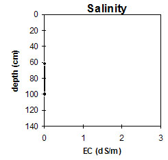 | 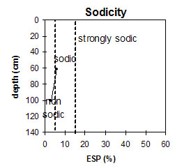 |
The sub-surface is strongly acid. The subsoil is moderately acid. | The salinity rating is very low in the subsurface and subsoil. | The subsurface is sodic. The subsoil is non-sodic. |
Management Considerations:
- This profile has a sandy loam to sandy clay loam texture throughout and therefore a high infiltration rate. The soil also has a very low inherent fertility throughout.
- The total surface is very deep (80 cm) and sandy, and the roots easily penetrate through to the subsoil. Earth worms were also observed at 30-44 cm depth.
- The subsurface horizon (44-80 cm) is strongly acid and this could promote an aluminium and manganese toxicity to plants. In fact, the levels of aluminium (38 ppm) could be toxic to phalaris and barley. Due to the aluminium being at this depth, however, adding lime would not be economic.
- The subsurface (44-80 cm) is also sodic but there is no dispersion present.
- Chisel seeder used for these flats where 60 kg per hectare of nitrogen and super are applied.
- The hills are largely native pasture and are seeded using an aeroplane.
© State of Victoria (Agriculture Victoria) 1996 - .

This work, Victorian Resources Online, is licensed under a Creative Commons Attribution 4.0 licence. You are free to re-use the work under that licence, on the condition that you credit the State of Victoria (Agriculture Victoria) as author, indicate if changes were made and comply with the other licence terms.
The licence does not apply to ‘branding’ or some ‘images or photographs’ that may be owned by third parties. We ask you to seek prior approval to use images using the VRO feedback form. Access to higher quality images can also be provided on request.
This page was last updated on .