
Kandosols
Kandosols lack strong texture contrast between the surface (A) horizons and subsoil (B) horizons. They are also characterised by having massive (structureless) or only very weakly structured subsoils and are often 'earthy' in appearance. Some part of the weakly developed B horizon must have a clay content of more than 15%. Kandosols are usually well drained, permeable soils and often have low fertility.
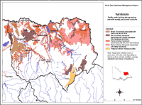
Note that other soil types may also occur within these mapped areas (either dominantly or sub-dominantly) depending on factors such as climate, landform, geology, vegetation and degree of weathering. This map will continue to be updated as new information becomes available. Access the Soil and Land Survey Directory from this website to find out about more detailed information from various soil and land surveys that cover parts of this region. |
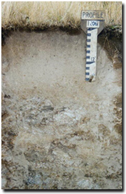 A Kandosol in the Hume catchment, developed on granite parent material. | Some of the soils now referred to as Kandosols were previously referred to as leptopodzols (Rowe 1967); reddish or yellowish-brown Gradational soils on alluvium (Rowe 1972); weakly bleached reddish-brown or yellowish-brown gradational soils (Rowe 1984), or reddish-brown or yellowish brown gradational soils on alluvium (Rowe 1984). Massive reddish and brownish gradational soils (Rowe 1972) were not described in detail but appear to also be Kandosols. Both Red and Brown Kandosols, and to a much lesser extent Yellow Kandosols, occur throughout the steep lower slopes and the alluvial/colluvial landscapes in North East Victoria. They are particularly common on steeper slopes associated with granitic and gneissic parent materials. The brown and yellow forms appear to be the more hydromorphic variations and generally occur in poorer drained situations than the red forms. These variations can often be found in association with each other, whether on hill slopes, or on terraces and fans. In general, Kandosols will often occur in association with other soil types such as Dermosols, Tenosols and Kurosols and there may be some gradations between these soil types. |
References:
Rowe, R.K (1967). A Study of the Land in the Victorian Catchment of Lake Hume. Soil Conservation Authority. Victoria. Technical Communication 5.
Rowe, R.K (1984). A Study of the Land in the Catchments of the Upper Ovens and King Rivers. Soil Conservation Authority. Victoria. Technical Communication 16.
Rowe, R.K (1972). A Study of the Land in the Catchment of the Kiewa River. Soil Conservation Authority. Victoria. Technical Communication 8.
© State of Victoria (Agriculture Victoria) 1996 - .

This work, Victorian Resources Online, is licensed under a Creative Commons Attribution 4.0 licence. You are free to re-use the work under that licence, on the condition that you credit the State of Victoria (Agriculture Victoria) as author, indicate if changes were made and comply with the other licence terms.
The licence does not apply to ‘branding’ or some ‘images or photographs’ that may be owned by third parties. We ask you to seek prior approval to use images using the VRO feedback form. Access to higher quality images can also be provided on request.
This page was last updated on .