
Site NE45
Property: Rutherglen Research Institute.
Paddock Number: 32.
Australian Soil Classification: Mottled-Sodic, Eutrophic, Yellow DERMOSOL
Northcote Factual Key: Gn 4.83
Great Soil Group: No suitable group.
General Landscape Description: Lower footslope (1% slope) of hill.
Soil Mapping Unit: Stillards loam
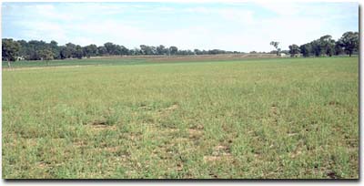 Site NE45 Landscape |
Soil Profile Morphology:
Surface Soil
| A1 | 0-10 cm | Strong brown (7.5YR4/6); fine sandy loam; hardsetting; weakly structured; firm consistence dry; pH 6.5; clear change to: |  Site NE45 Profile |
| A2 | 10-18 cm | Strong brown (7.5YR5/6) (7.5YR6/4d); light fine sandy clay loam; contains a common (10%) amount of ferromanganiferous nodules (2-10 mm size); firm consistence dry; pH 5.9; abrupt change to: | |
| Subsoil: | |||
| B1 | 18-35 cm | Reddish yellow (7.5YR6/6); fine sandy clay loam, becoming light clay with depth; weakly structured; very firm consistence dry; contains a few (2-5%) ferromanganiferous nodules; pH 6.8; gradual change to: | |
| B21 | 35-70 cm | Brownish yellow (10YR6/8) with dark yellowish brown (10YR3/6) mottles; light medium clay; moderate medium polyhedral, parting to strong fine polyhedral structure; strong consistence dry; contains some patches of quartz from 50 cm depth; pH 6.8; clear change to: | |
| B22 | 70-90 cm | Yellowish brown (10YR5/8) with yellowish brown (10YR5/6) mottles; medium heavy clay; moderate medium polyhedral, parting to strong fine polyhedral structure; strong consistence dry; contains a few (5-10%) manganese stains; pH 6.6; gradual change to: | |
| B31 | 90-120 cm | Yellowish brown (10YR5/4) with bright yellowish brown (10YR5/8) mottles; medium heavy clay; moderate very coarse prismatic, parting to strong medium polyhedral structure; strong consistence dry; contains many (20%) manganese stains and patches of quartz gravel; pH 7.6; gradual change to: | |
| B32 | 120 cm+ | Brown (10YR5/3) with yellowish brown (10YR5/6) and strong brown (7.5YR4/6) mottles; medium heavy clay; moderate very coarse prismatic, parting to strong medium polyhedral structure; strong consistence dry; contains a common (10%) amount of manganese stains; pH 8.5. | |
Key Profile Features:
- Lack of strong texture contrast between surface (A) horizons and subsoil (B21) horizon.
- Contains a significant amount of soft manganese segregations in the deeper subsoil.
 | The surface soil is slightly acid and the subsurface (A2) horizon is moderately acid. The upper subsoil is mainly slightly acid. The deeper subsoil gradually increases from slightly alkaline to moderately alkaline. | 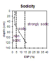 | The upper part of the profile is non-sodic. At 80 cm depth the subsoil becomes sodic. The deep subsoil (120 cm+) is sodic and strongly dispersive. Also note the prismatic structure. |
 | There is a very low level of soluble salts throughout the profile. |  | The clay context increases gradually with depth. |
Horizon | Horizon Depth (cm) | pH (water) | pH (CaCl2) | EC 1:5 | Exchangeable Cations | Field Capacity pF 2.5 | Wilting Point pF 4.2 | Coarse Sand (0.2 - 2.0 mm) | Fine Sand (0.02 -0.2 mm) | Silt (0.002 -0.02 mm) | Clay (<0.002 mm) | |||
Ca | Mg | K | Na | |||||||||||
meq/100g | ||||||||||||||
A1 | 0-10 | 6.5 | 5.4 | 0.05 | 3 | 0.53 | 0.89 | 0.11 | 23 | 5 | 9 | 55 | 21 | 14 |
A1 | 10-18 | 5.9 | 5.1 | 0.08 | 2.9 | 0.58 | 0.41 | 0.11 | 20 | 6 | 10 | 51 | 25 | 17 |
B1 | 18-35 | 6.8 | 5.8 | <0.05 | 3.7 | 1.2 | 0.5 | 0.07 | 22 | 9 | 12 | 43 | 20 | 27 |
B21 | 35-70 | 6.8 | 5.8 | <0.05 | 4 | 3 | 0.52 | 0.21 | 27 | 12 | 8 | 36 | 15 | 42 |
B22 | 70-90 | 6.6 | 5.4 | 0.05 | 3.2 | 4.7 | 0.45 | 0.66 | 27 | 14 | 7 | 33 | 14 | 47 |
B31 | 90-120 | 7.6 | 5.9 | <0.05 | 3.9 | 6.4 | 0.55 | 1.5 | 9 | 17 | 5 | 30 | 13 | 51 |
B32 | 120+ | 8.5 | 6.8 | 0.06 | 4.8 | 8 | 0.59 | 2.4 | 32 | 18 | 5 | 29 | 13 | 53 |
Management Considerations:
Whole Profile
- Plant available water capacity (PAWC) is considered to be low (estimated at 85 mm) for the top metre of the soil profile. This is based on available laboratory data.
- The surface soil has a high fine sand and silt content (76 %). The stability of the soil structure on these soils depends largely on organic matter to maintain aggregation and prevent slaking. The organic carbon value is low (0.9%) at this pit site. Organic matter levels can be improved by adopting practices such as minimum tillage, stubble retention, pasture rotations and direct drilling.
- The surface soil has a low nutrient status (based on the sum of the exchangeable basic cations). Improving organic matter levels will assist in increasing soil fertility and water holding capacity.
- The relatively low wilting point value (5%) indicates that plants will be able to utilise light rains falling on relatively dry soil.
- The upper subsoil is non-sodic with a reasonably high exchangeable calcium:magnesium ratio and is quite well structured (parting to fine polyhedral shaped peds). As a result, root and water movement will not be significantly restricted. The deeper subsoil is sodic and strongly dispersive. This will restrict deep drainage.
- The upper subsoil has a low-medium nutrient status (based on the sum of the exchangeable basic cations).
- The presence of manganese staining in the deep subsoil may have a toxic effect on deep-rooted manganese sensitive plants.
- Deep ripped in 1984 and cultivated five times since 1984.
- Paraploughed in 1990.
- Lucerne sown in 1994.
- Lime not used in the last 12 years.
© State of Victoria (Agriculture Victoria) 1996 - .

This work, Victorian Resources Online, is licensed under a Creative Commons Attribution 4.0 licence. You are free to re-use the work under that licence, on the condition that you credit the State of Victoria (Agriculture Victoria) as author, indicate if changes were made and comply with the other licence terms.
The licence does not apply to ‘branding’ or some ‘images or photographs’ that may be owned by third parties. We ask you to seek prior approval to use images using the VRO feedback form. Access to higher quality images can also be provided on request.
This page was last updated on .