
Site NE41
Property: Rutherglen Research Institute.
Paddock Number: 2 East.
Australian Soil Classification: Mottled, Eutrophic, Brown CHROMOSOL.
Northcote Factual Key: Dy 3.32
Great Soil Group: No suitable group.
General Landscape Description: Original vegetation included Yellow Box (E. melliodora) and Yellow Gum (E. leucoxylon).
Soil Mapping Unit: Rutherglen loam (normal phase).
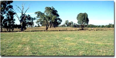 Site NE41 Landscape |
Soil Profile Morphology:
Surface Soil
| A1 | 0-15 cm | Dark yellowish brown (10YR4/4); fine sandy loam; weak coarse blocky structure; weak consistence moist; pH 5.4; abrupt change to: | 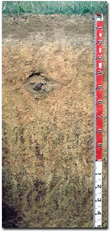 Site NE41 Profile |
| A2 | 15-20 cm | Yellowish brown (10YR5/4) sporadically bleached; light fine sandy clay loam; structureless; firm consistence dry; pH 6.1; abrupt change to: | |
| Subsoil | |||
| B21 | 20-40 cm | Strong brown (7.5YR5/6);light medium clay; weak coarse blocky, parting to medium blocky structure; strong consistence dry; pH 7.1; gradual change to: | |
| B22 | 40-70 cm | Strong brown (7.5YR5/6) with dark red (2.5YR4/8) mottles; medium clay; moderate medium polyhedral structure; strong consistence dry; pH 7.5: | |
| B23 | 70-110 cm | Brownish yellow (10YR6/6) with yellowish red (5YR5/8) mottles; light medium clay; strong consistence dry; contains a common (15%) amount of manganese concretions (10-15 mm size); pH 7.8: | |
| B3 | 110 cm+ | Pale brown (10YR6/3) with brownish yellow (10YR6/6) and strong brown (7.5YR5/6) mottles; medium heavy clay; moderate coarse prismatic, parting to moderate coarse blocky to fine blocky structure; strong consistence dry; contains a common (15%) amount of manganese segregations (10 -15 mm size); pH 7.8. | |
Soil Profile Characteristics:
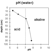 | The surface horizon is strongly acid. The subsurface (A2) horizon is slightly acid. The subsoil is slightly alkaline | 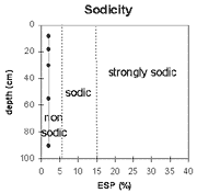 | The soil profile is non-sodic throughout. |
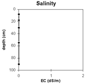 | Soluble salt levels are very low throughout the soil profile. | 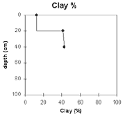 | The clay percentage increases significantly at the A/B horizon interface. |
Horizon | Horizon Depth (cm) | pH (water) | pH (CaCl2) | EC 1:5 | Exchangeable Cations | Exchangeable Aluminium mg/kg | Field Capacity pF 2.5 | Wilting Point pF 4.2 | Coarse Sand (0.2 - 2.0 mm) | Fine Sand (0.02 -0.2 mm) | Silt (0.002 -0.02 mm) | Clay (<0.002 mm) | |||
Ca | Mg | K | Na | ||||||||||||
meq/100g | |||||||||||||||
A1 | 0-15 | 5.4 | 4.4 | <0.05 | 1.4 | 0.49 | 0.47 | <0.05 | 14 | 24 | 5 | 9 | 54 | 24 | 13 |
A2 | 15-20 | 6.1 | 5.2 | <0.05 | 3.3 | 0.69 | 0.43 | 0.06 | |||||||
B21 | 20-40 | 7.1 | 5.9 | <0.05 | 6.1 | 1.8 | 0.74 | 0.13 | 27 | 13 | 6 | 37 | 17 | 41 | |
B22 | 40-70 | 7.5 | 6.3 | <0.05 | 6.1 | 2.4 | 0.74 | 0.13 | 29 | 13 | 5 | 36 | 15 | 43 | |
B23 | 70-110 | 7.8 | 6.6 | <0.05 | 5.1 | 2.7 | 0.67 | 0.14 | 26 | 11 | |||||
B3 | 110 | 7.8 | 6.5 | <0.05 | 6.2 | 7.2 | 0.98 | 0.7 | |||||||
Management Considerations:
Whole Profile
- Plant available water capacity (PAWC) is considered to be low (estimated at 90 mm) for the top metre of the soil profile. This is based on available laboratory data. Most plant roots in the soil pit were in the top 50 cm (indicating an estimated PAWC of 60 mm).
- The level of exchangeable aluminium level is low (14 mg/kg) in the strongly acid surface soil. These levels are unlikely to affect plant growth. A pH/aluminium test on a bulked sample (sampled from across the paddock) would be most appropriate to determine if lime is needed to raise soil pH.
- The surface soil has a high fine sand and silt content (i.e. 78 %). Soil structural stability of such soils depends largely on organic matter. Management practices which increase soil organic matter (i.e. minimum tillage, retaining crop residues, pasture rotations) should be adopted. The organic carbon value is quite low (0.9%) at this pit site.
- The surface soil disperses slightly after remoulding. This indicates that some structural degradation may occur if the soil is cultivated whilst in a moist to wet condition. Cultivation of such a soil in a dry condition may also be deleterious to soil structure due to the high fine sand and silt content. It is likely to become 'powdery' when cultivated dry, and surface sealing may result after subsequent rains.
- The nutrient status (based on the sum of the exchangeable basic cations) of the surface soil is very low at this site. Increasing organic matter levels will enhance fertility as well as water holding capacity.
- The relatively low wilting point value (i.e. 5%) indicates that plants will be able to utilise light rains falling on relatively dry soil.
- The subsoil is non-sodic, has a relatively high calcium:magnesium ratio and is non dispersive. Root and water movement is therefore not likely to be significantly restricted.
- The large amount of manganese segregations in the deeper subsoil (i.e. from 70 cm depth) may have a toxic effect on deeper rooted manganese sensitive plants.
The nutrient status (based on the sum of the basic exchangeable cations) is low-moderate.
- Top dressed with 1 cwt lime super/acre - 87 bags.
- Cultivated in 1972-73 and disc harrowed in 1974.
- Super/ac topdressing in 1974, 75, 76, 77, 80, 82.
© State of Victoria (Agriculture Victoria) 1996 - .

This work, Victorian Resources Online, is licensed under a Creative Commons Attribution 4.0 licence. You are free to re-use the work under that licence, on the condition that you credit the State of Victoria (Agriculture Victoria) as author, indicate if changes were made and comply with the other licence terms.
The licence does not apply to ‘branding’ or some ‘images or photographs’ that may be owned by third parties. We ask you to seek prior approval to use images using the VRO feedback form. Access to higher quality images can also be provided on request.
This page was last updated on .