
Dermosols
Dermosols lack strong texture contrast between surface (A) horizons and the upper subsoil (B2). The subsoils are also structured (as opposed to Kandosols which lack structure).
Note that other soil types may also occur within these mapped areas (either dominantly or sub-dominantly) - depending on factors such as climate, landform, geology, vegetation and degree of weathering. This map will continue to be updated as new information becomes available. Access the Soil and Land Survey Directory from this website to find out about more detailed information from various soil and land surveys that cover parts of this region. |
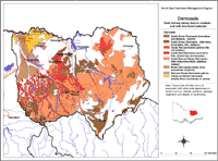
Dermosols are widespread throughout the North East region and are most commonly Red or Brown Dermosols. In the higher rainfall areas they are generally strongly acid throughout. Dermosols can occur in many landscapes (from lower terraces to mountains) and have developed on a range of rock types.
Red Dermosols Previously referred to as:
loam to clay loam texture, dark brown A1, overlying yellowish red or reddish brown A2, gradual boundary change. Subsoil (B2) horizon clay loam to light clay texture, strong sub-angular blocky structure, strongly acid, low nutrient status. | 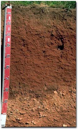 Acidic Red Dermosol on lower river terrace in the Tallangatta Valley. |
Brown Dermosols (mountain areas) Previously referred to as:
Surface (A) horizons forest litter (O horizon), overlying dark brown to black organic loam A1 horizon (up to 15 cm thick) with strong fine granular structure, gradual boundary change. Subsoil (B2) horizon clay loam to light clay texture, strongly acid, dystrophic. |  Acidic Brown Dermosol found in mountainous areas. |
Yellow and Brown Dermosols (plains) Occurrence:
Surface (A) horizons fine sandy clay loam, darker A1 horizon, overlying paler (often bleached) A2 horizon, weakly structured, clear to gradual boundary change. Subsoil (B2) horizon clay loam to light clay texture, becoming more clayey and alkaline with depth, often with many manganese stains at depth, well developed structure. | 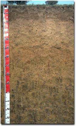 Yellow Dermosol found on plains in the Rutherglen area. |
Rowe, R.K (1967). A Study of the Land in the Victorian Catchment of Lake Hume. Soil Conservation Authority. Victoria. Technical Communication 5.
Rowe, R.K (1972). A Study of the Land in the Catchment of the Kiewa River. Soil Conservation Authority. Victoria. Technical Communication 8.
Rowe, R.K (1984). A Study of the Land in the Catchments of the Upper Ovens and King Rivers. Soil Conservation Authority. Victoria. Technical Communication 16.
© State of Victoria (Agriculture Victoria) 1996 - .

This work, Victorian Resources Online, is licensed under a Creative Commons Attribution 4.0 licence. You are free to re-use the work under that licence, on the condition that you credit the State of Victoria (Agriculture Victoria) as author, indicate if changes were made and comply with the other licence terms.
The licence does not apply to ‘branding’ or some ‘images or photographs’ that may be owned by third parties. We ask you to seek prior approval to use images using the VRO feedback form. Access to higher quality images can also be provided on request.
This page was last updated on .