
North East Salinity Strategy Implementation (NESSI) Newsletter Winter 2010 - Edition No. 43
Providing land management information to the community
Download the PDF version of this document: NESSI Newsletter - Winter 2010 (PDF 1.5MB)
To view the information PDF requires the use of a PDF reader. This can be installed for free from the Adobe website (external link).
Inside this issue:  |
 | Welcome to the winter edition of NESSI. For more than a decade the NESSI newsletter has been distributed to landholders across the North East, providing information on a range of topics associated with land management. This newsletter has been an important tool for the DPI land management team to communicate its programs, incentives and events to landholders. Over the coming year you may notice changes not only to this newsletter but the way in which our programs and incentives are delivered. This is due to a number of reasons, such as a more strategic approach in delivering incentives and a wider restructure of DPI. You will also notice a different NESSI editor as I am taking 12 months off on maternity leave. I would like to take this opportunity to thank all the contributors, that have make it possible to produce each edition. If you have any questions or are seeking advice about land management issues, please contact staff listed on the back page. Kylie Macreadie - Editor |
Around the catchment
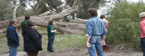
| Whole Farm Planning Course dates Learn about: principles of whole of property anagement, land classing and land degradation, understanding what type of soils you have and how to manage them, pastures and grazing management and lots more. Mapping will be completed electronically. DPI staff will run courses at the following locations on these dates. Course: Farming in the Upper Murray. Location: Upper Murray Dates: September 2-3 and 9-10 (Thursdays and Fridays) Course: Managing Your Rural Property Location: Wangaratta Dates: September 23-24 and 30 and October 1 (Thursdays and Fridays) Course: Managing Your Small Farm Location: Yackandandah Dates: October 22-23 (Friday/Sat), 29 (Friday), November 5 (Friday) For more information contact Mary Anderson at DPI Wangaratta on (03) 5723 8655. Top | |||||||||||||||||||||||||||||||||||||||||||||||||||||||||||||||||||||||
| Sustainable farming practices program - soils North East Catchment Management Authority (NECMA) Soil testing has been keeping staff busy with approximately 300 soil tests taken for 78 landholders. The use of a mechanical soil probe has made life much easier for the field staff and allowed up to three sites to be visited each day. Landholders who are interested in participating should contact the NECMA reception, even though we have sufficient numbers for this financial year we will continue on in 2010-11. Once we have sufficient land holders in an area with soil test results, the participants will be offered a place in a small group and have access to free agronomic advice. For more information contact Suzanne Johnstone at NECMA Wodonga on (02) 6043 7600. | |||||||||||||||||||||||||||||||||||||||||||||||||||||||||||||||||||||||
| eFarmer training - North East Catchmetn Management Authority (NECMA) eFarmer is a web-based mapping program that allows landholders access to Geographical Information System (GIS) with aerial photography, latitude /longitude coordinates, property boundaries, public land areas, declared waterways, native vegetation location and its conservation status and much more. Training is still available in eFarmer for groups of six landholders across the region. Training is free and all materials are supplied. A personalised log-in is given for privacy. The training is also relevant for Landcare members to allow for simple mapping of all proposed or past works. For more information contact Suzanne Johnstone at NECMA Wodonga on (02) 6043 7600. | |||||||||||||||||||||||||||||||||||||||||||||||||||||||||||||||||||||||
| Box Ironbark course Nagambie, October 4-8, 2010 This course brings together leading researchers and experts to present their up-to-date knowledge and thinking about this landscape in change. The course is aimed at a mix of people representing public and private land managers of Box Ironbark remnants and other key interest groups. The course is field-based and participants work in small groups. It emphasises ecological understanding and relationships and techniques that improve observation and data collection skills which can then be applied to other areas. Participants will gain:
The course is based at Nagambie in central Victoria, in the heart of Box Ironbark country. The course fee is $1400 + GST and includes accommodation, meals, transport, instruction, course notes. A deposit ($770) or full fee payable with application. Balance payable by 20 September 2010. Accommodation is in own rooms in shared cabins and catering covers meals and most refreshments. Under the Federal Government’s FARMREADY program, primary producers and indigenous land managers are eligible for a reimbursement of the costs associated with attending this course. For more information please contact Department of Sustainability and Environment Benalla on (03) 5761 1611. Top | |||||||||||||||||||||||||||||||||||||||||||||||||||||||||||||||||||||||
| Victorian Resources Online (VRO) VRO is your gateway to a wide range of natural resources information and associated maps. You can access this information at both statewide and regional levels across Victoria. Information can be accessed for categories such as climate, landform, land use, soil, water, biodiversity, land and water management. The web site can be found at www.dpi.vic.gov.au/vro. |  | ||||||||||||||||||||||||||||||||||||||||||||||||||||||||||||||||||||||
| Threatened grassy woodlands project update (NE Catchment) The Threatened Grassy Woodlands project has been up and running in the North East Catchment Managenent Authority(NECMA) since late 2009. The objective of the project is to protect and manage 2500 hectares of nationally threatened grassy woodlands across three regions in Victoria and NSW. The project is supported by the NECMA in collaboration with the Goulburn Broken and Murray CMAs, Australian National University, Trust for Nature and Nature Conservation Trust (NSW). It is funded by the Australian Government, Caring for our Country program. | 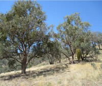 | ||||||||||||||||||||||||||||||||||||||||||||||||||||||||||||||||||||||
During the first half of 2010, eight landholders have signed up to protect over 250 ha of Box-Gum Grassy Woodland in the North East Catchment. Trust for Nature has also secured 45ha of Box-Gum Grassy Woodland under conservation covenants with three landholders. Landholders have been funded to undertake a range of management activities, including:
Another highlight of the project has been the establishment of 18 permanent biodiversity monitoring sites by the Australian National University. The monitoring sites will provide valuable data on the responses of plant and animal populations to different management regimes. This is very exciting work and will underpin future decision making for management actions in threatened grassy woodlands. The next round of private land funding has also commenced with expressions of interest being sought and potential funding sites being assessed. Box-Gum Grassy Woodland occurs on lower slopes and foothills of North East Victoria where the dominant tree species include White Box, Yellow Box or Blakely’s Red Gum (also known as Hill Red Gum). Landholders with areas of Box-Gum Grassy Woodland on their property are invited to contact Matt Looby at DSE Wangaratta on (03) 5723 8673. Top | |||||||||||||||||||||||||||||||||||||||||||||||||||||||||||||||||||||||
| Stream salinity monitoring in North East Victoria Since January 2005, monthly salinity monitoring of 59 waterways across the North East region has occurred. A spot sample (one-off recording) is taken at each waterway during the first week of the month to test the water salinity. This monitoring was established to identify salinity hotspots in streams and assist in identifying areas where on-ground works could be targeted in the future. There are 240 mapped saline discharge sites in North East Victoria which impact on approximately 1300ha of land. Approximately 54 per cent of saline discharge sites are located within 100 metres of a waterway. Salinity can be measured using two units Electrical Conductivity (EC) and Total Dissolved Salts (TDS). Electrical Conductivity is measured as micro Siemens per centimetre (ìs/cm) and Total Dissolved Salts is milligrams of dissolved solid in one litre of water (mg/ L). Parts per million (ppm) is equivalent to mg/L. Therefore 100 ìs/cm (EC) = 64mg/L or 64ppm. Measurement is taken using a small hand held device, that only takes a few seconds. The data presented in this table is in Electrical Conductivity (EC) (ìs/cm) and is for a selection of the waterways that are monitored. | |||||||||||||||||||||||||||||||||||||||||||||||||||||||||||||||||||||||
| To help explain just how salty these results are, consider some of the salinity tolerance levels for uses of water: This monitoring of streams is part of a larger program to improve our understanding of salinity in the region. Also monitored monthly is 330 groundwater bores which provide us with a detailed understanding of groundwater trends. Updates on groundwater trends have often appeared in this newsletter. Article by Kylie Macreadie, DPI Wodonga | 800 EC – Ideal limit for people to drink 1600 EC – Limit for hot water systems 2000 EC – Limit for irrigating Lucerne 11,000 EC – Limit for lambs 15,000 EC – Limit for beef cattle 50,000 EC – Sea water. | ||||||||||||||||||||||||||||||||||||||||||||||||||||||||||||||||||||||
Top | |||||||||||||||||||||||||||||||||||||||||||||||||||||||||||||||||||||||
| Critically Regent Honeyeaters go wild Forty-four captive-bred Regent Honeyeaters were released at the start of May 2010 into Chiltern-Mt Pilot National Park as part of a national recovery program to curb the species’ decline. Regent Honeyeaters are classified as critically endangered nationally – with less than 1000 birds in the wild across their south east Australian range. This release represents a significant injection of birds into the north east Victorian population which otherwise numbers as few as 100 birds. A highly successful volunteer/community based monitoring program has been coordinated by DSE and Birds Australia. Well over 100 volunteers have contributed to the seven days-a-week monitoring program, through the rain, fog and shine experienced in this winter so far. Up until mid July (10 weeks and post release) an amazing 80 per cent of birds have survived and are still being actively monitored. | 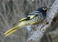 Photo: Nevil Lazarus | ||||||||||||||||||||||||||||||||||||||||||||||||||||||||||||||||||||||
| All released birds have unique colour leg bands that enable individual bird identification. In addition we have banded four of the eight sighted wild Regents in the park. Several pair bonds have been established between captive released birds and even between wild and captive birds. Our monitoring focus over the next month will endeavour to record the outcome of anticipated breeding events. DSE planned the 2010 release to coincide with an anticipated good year for winter flowering eucalypts. Our expectations have been realised with Mugga Ironbark (Eucalyptus sideroxylon) and White Box (E. albens) and their naturally occurring (Box Ironbark) hybrid yielding well in the park. However, Regents are notoriously difficult to track down once flowering of these winter-based species declines. If you see a Regent Honeyeater, DSE would love to hear from you. We expect that both the wild and ex-captive Regents in Chiltern Mt. Pilot National Park will be on the move at the time this NESSI edition goes to print. This is where you can help. The birds will travel along vegetated roadsides to seek out areas supporting flowering natives, including private land bush remnants and even native based gardens e.g. flowering bottlebrush and grevillea – and bird baths or nearby farm dams offer an added attraction. | |||||||||||||||||||||||||||||||||||||||||||||||||||||||||||||||||||||||
| Help us determine where our Regents go in spring and summer. Sighting records are invaluable, as they help us piece together habitat use, seasonal movement and breeding patterns. Please report (ASAP) upon sighting to: Dean Ingwersen, Regent Honeyeater National Coordinator: Free Call 1800 621 056 or d.ingwersen@birdsaustralia.com.au. | 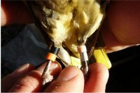 Photo: Glen Johnson | ||||||||||||||||||||||||||||||||||||||||||||||||||||||||||||||||||||||
Details sought:
Banded Regents have two colour bands on each leg. Each bird's 'four band combination' enable individuals to be uniquely identified - back to the point of capture (wild birds) or release (captive bred birds). A master colour band always sits over a metal band, that includes a unique stamped band number. The remaining leg will have two colour bands. Note: band colour sequence is recorded from top to bottom i.e. body to claw. Identifying band colours can be a challenge. Good binoculars will greatly assist your identification. A colour band information sheet is available with lots of colour photos and further tips, if you are interested contact Sarah Kelly at DSE Wangaratta on (03) 5723 8659. Landowners can make a significant contribution to the long-term survival of the Regent Honeyeater by protecting Box Ironbark forests and woodland habitats that occur on their properties. Incentives are available to assist to protect existing habitat and revegetate properties. Contact your DSE/DPI extension officer for more details. Article by Glen Johnson, DSE Wodonga. Top | |||||||||||||||||||||||||||||||||||||||||||||||||||||||||||||||||||||||
| Monitoring your irrigation over the season Irrigators know the importance of applying the right amount of water at the right time in order to maximise crop production, but how do you know if it is right? In the coming irrigation season, DPI staff will be conducting a program to help irrigators record when and how irrigation water is applied and compare this to theoretical crop water use. Throughout the irrigation season, irrigators will be able to gauge if they are applying too much or too little water for the conditions at the time. This is particularly important for spray irrigation where insufficient irrigation applications can lead to moisture stress. In the example shown in Graph 1, irrigation occurred too late and was too little at the start of the season. It was not until mid October when moisture levels were sufficient to avoid plant stress, through to January, where the irrigation was unable to keep up with plant use. In this example the crop has spent 40 per cent of its time under moisture stress (above the dotted red line). However, it would have only taken one more irrigation of 25mm at the start of the year to reduce this figure to 10 per cent. | 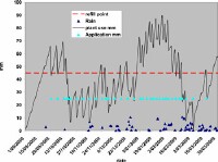 Graph1: An example of irrigation and rainfall compared to plant use. When plant use is above the red line plants are stressed | ||||||||||||||||||||||||||||||||||||||||||||||||||||||||||||||||||||||
 | |||||||||||||||||||||||||||||||||||||||||||||||||||||||||||||||||||||||
For information on land and biodiversity management contact any of the following DPI or DSE staff.
| Peter Ockenden, Team Leader | (03) 5723 8674 | Sarah Kelly, Biodiversity Officer | (03) 5723 8659 |
| Ian Gamble, CMO | (03) 5723 8671 | Mary Titcumb, Biodiversity Officer | (03) 6043 7956 |
| Mary Anderson, CMO | (03) 5723 8655 | Kate Hill, Biodiversity Officer | (02) 6043 7926 |
| Craig Turton, CMO | (03) 5723 8682 | Matt Looby, Project Officer | (03) 5723 8673 |
| Phillippa Noble, Private Forestry | (03) 5723 8686 | ||
DPI/DSE Wangaratta Office 62-68 Ovens Street Wangaratta Phone: (03) 5723 8600 Fax: (03) 57214423 | DPI/DSE Wodonga Office 1 McKoy Street Wodonga Phone: (02) 6043 7900 Fax: (02) 6043 7910 | ||
© State of Victoria (Agriculture Victoria) 1996 - .

This work, Victorian Resources Online, is licensed under a Creative Commons Attribution 4.0 licence. You are free to re-use the work under that licence, on the condition that you credit the State of Victoria (Agriculture Victoria) as author, indicate if changes were made and comply with the other licence terms.
The licence does not apply to ‘branding’ or some ‘images or photographs’ that may be owned by third parties. We ask you to seek prior approval to use images using the VRO feedback form. Access to higher quality images can also be provided on request.
This page was last updated on .