
NE32
| Group: Tallangatta Valley Landcare Group | Australian Soil Classification: |
| General Landscape Description: Acidic, Eutrophic, Black DERMOSOL | Northcote Factual Key: Um 6.31 |
| Great Soil Group: prairie soil | |
| General Landscape Description: Alluvial flats in upper reaches of Tallangatta Creek. | |
| Site Description: | |
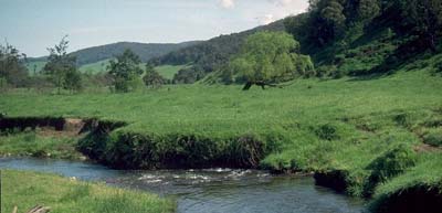 NE32 landscape |
Soil Profile Morphology:
Surface Soil
A11 | 0-10 cm | Very dark brown (10YR2/2); loam (fine sandy); moderate medium polyhedral, parting to strong fine polyhedral structure; weak consistence dry; pH 5.0;clear change to: | 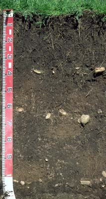 NE32 profile |
A12 | 10-40 cm | Very dark brown (10YR2/2); loam (fine sandy); moderate medium polyhedral, parting to strong fine blocky structure; firm consistence moderately moist; contains a layer of river pebbles at 35-40 cm depth; pH 6.1; clear change to: | |
| Subsoil | |||
B21 | 40-60 cm | Dark brown (10YR3/3); light clay (fine sandy); weak medium blocky structure; firm consistence moderately moist; pH 5.1; clear change to: | |
B22 | 60-90 cm | Very dark greyish brown (10YR3/2) with patches of brown (10YR5/3) and dark brown (7.5YR3/4); light sandy clay loam; moderate medium blocky structure; firm consistence moderately moist; contains a layer of river pebbles at 60-65 cm depth; pH 6.2: | |
2A | 90-110 cm | Brown (7.5YR4/4); sandy loam; weak coarse blocky structure; weak consistence moderately moist; contains a layer of river pebbles at 100-105 cm depth. | |
Soil Profile Characteristics:
Horizon | pH | Salinity Rating | ||
Surface (A1 horizon) | strongly acid | very low | non sodic | none |
Subsoil (B21 horizon) | strongly acid | very low | non sodic | none |
Deeper subsoil (at 60-90 cm) | slightly acid | very low | non sodic | none |
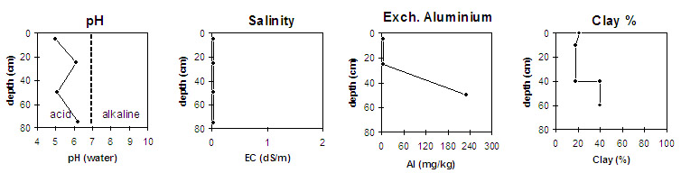
Horizon | Horizon Depth (cm) | pH (water) | pH (CaCl2) | EC 1:5 | Exchangeable Cations | |||
Ca | Mg | K | Na | |||||
meq/100g | ||||||||
A1 | 0-10 | 5 | 4.2 | <0.05 | 8.6 | 1.8 | 0.20.1 | |
B21 | 10-40 | 6.1 | 5 | <0.05 | 4.7 | 2 | 0.2<0.1 | |
B22 | 40-60 | 5.1 | 4.3 | <0.05 | ||||
B23 | 60-90 | 6.2 | 5 | <0.05 | ||||
Horizon | Horizon Depth (cm) | Exchangeable Aluminium mg/kg | Field Capacity pF 2.5 | Wilting Point pF 4.2 | Coarse Sand (0.2-2.0 mm) | Fine Sand (0.02-0.2 mm) | Silt (0.002-0.02 mm) | Clay (<0.002 mm) |
A1 | 0-10 | <10 | 29.7 | 10.1 | 14 | 37 | 24 | 21 |
B21 | 10-40 | <10 | 26.9 | 8.1 | 20 | 39 | 23 | 18 |
B22 | 40-60 | 230 | 27.1 | 12.5 | 11 | 29 | 20 | 40 |
B23 | 60-90 | 17 | 39 | 23 | 18 |
Management Considerations:
Whole Profile
- Plant available water capacity (PAWC) is considered to be medium (estimated at 135 mm) for this site. This is based on available laboratory data and assumes an effective rooting depth of 120 cm.
Surface (A) Horizons
- The surface soil is strongly acid which indicates that aluminium and manganese toxicity may occur. The level of exchangeable aluminium measured at this creek cutting is, however, quite low. A pH/aluminium test is best done, however, on a bulked sample taken across the paddock. Other factors need to be considered before lime is recommended (eg. pasture species grown, method of application, local trial responses, soil surface structure and likely cost/benefit)
- The pH increases in the subsurface (A12) horizon which is a good result as aluminium levels will be negligible.
- The surface soil has a moderate overall nutrient status (based on the sum of the exchangeable basic cations).
Subsoil (B) Horizons
- The upper subsoil is strongly acid and the level of exchangeable aluminium measured is high (230 mg/kg). This is likely to restrict the growth of a number of aluminium sensitive species.
Notes
Profile described by Mark Imhof, Paul Rampant and Karen De Plater (25/10/95).
© State of Victoria (Agriculture Victoria) 1996 - .

This work, Victorian Resources Online, is licensed under a Creative Commons Attribution 4.0 licence. You are free to re-use the work under that licence, on the condition that you credit the State of Victoria (Agriculture Victoria) as author, indicate if changes were made and comply with the other licence terms.
The licence does not apply to ‘branding’ or some ‘images or photographs’ that may be owned by third parties. We ask you to seek prior approval to use images using the VRO feedback form. Access to higher quality images can also be provided on request.
This page was last updated on .