
NE18
| Group: Springhurst-Byawatha Hills Landcare Group | Australian Soil Classification: Basic, Lithic, Orthic TENOSOL (medium, very gravelly, loamy/moderate depth) |
| Northcote Factual Key: | Great Soil Group: lithosol |
| General Landscape Description: Midslope (2% slope) of a metamorphic rise. Original vegetation included Grey Box (Eucalyptus microcarpa). |
Site Description:
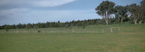 NE18 landscape |
Soil Profile Morphology:
Surface Soil
A1 | 0-15 cm | Very dark greyish brown (10YR3/2); sandy loam; massive (structureless); hardsetting surface condition; very firm consistence dry; contains very many (60%) rock fragments (10 mm average size); pH 5.3; clear change to: | 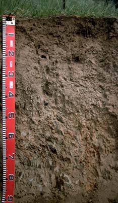 NE18 profile |
A2 | 15-50 cm | Brown (10YR4/3) conspicuously bleached (10YR7/3d); sandy loam; massive (structureless); very firm consistence dry; containsvery many (50%) shale fragments (20 mm average size); pH 6.1; clear change to: | |
| Subsoil | |||
B/C | 50-70cm | Dark red (2.5YR4/6) with yellowish red (5YR5/8) and grey mottles; clay loam which occurs in cracks between bedding of base rock; weakly structured; contains 90% baserock; pH 6.9. | |
Key Profile Features:
- High amount of rock fragments throughout soil profile.
Soil Profile Characteristics:
Horizon | pH | Salinity Rating | ||
Surface (A1 horizon) | strongly acid | very low | non-sodic | none |
Subsoil (B21 horizon) | slightly acid | very low | non-sodic | none |
Deeper subsoil (at 60 cm) | slightly acid | very low | non-sodic | none |
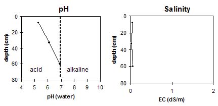
Horizon | Horizon Depth (cm) | pH (water) | pH (CaCl2) | EC 1:5 | Exchangeable Cations | |||
Ca | Mg | K | Na | |||||
meq/100g | ||||||||
A1 | 0-15 | 5.3 | 4.5 | 0.05 | 6.5 | 1.4 | 0.9 | <0.1 |
A2 | 15-50 | 6.1 | 5.2 | <0.05 | 1.5 | 1.3 | 0.5 | <0.1 |
B/C | 50+ | 6.9 | 6.1 | 0.06 | 1.4 | 4.6 | 0.4 | <0.1 |
Horizon | Horizon Depth (cm) | Exchangeable Aluminium mg/kg | Field Capacity pF 2.5 | Wilting Point pF 4.2 | Coarse Sand (0.2-2.0 mm) | Fine Sand (0.02-0.2 mm) | Silt (0.002-0.02 mm) | Clay (<0.002 mm) |
A1 | 0-15 | 10 | ||||||
A2 | 15-50 | |||||||
B/C | 50+ |
Management Considerations:
Whole Profile
- Plant available water capacity (PAWC) is considered to be low for this soil profile due to the shallow profile development and high gravel content.
- Soil profile drainage is likely to be high due to the high rock content throughout the shallow soil profile. The fractured and well weathered baserock will also be highly permeable.
Surface (A) Horizons
- The surface soil is strongly acid. The exchangeable aluminium measured at the pit site is, however, quite low. This is a good result if this site is representative of the whole paddock. A pH/aluminium test on a bulked sample taken from across the paddock would be most appropriate for determining whether lime is needed to raise soil pH.
- The high rock and gravel content throughout the profile will restrict the development of plant roots.
- The pH increases in the A2 horizon and exchangeable aluminium levels are likely to be low.
Subsoil (B) Horizon
- The subsoil is only weakly developed and exists in cracks between the weathered baserock. It has a high level of exchangeable magnesium in relation to calcium and is poorly structured.
© State of Victoria (Agriculture Victoria) 1996 - .

This work, Victorian Resources Online, is licensed under a Creative Commons Attribution 4.0 licence. You are free to re-use the work under that licence, on the condition that you credit the State of Victoria (Agriculture Victoria) as author, indicate if changes were made and comply with the other licence terms.
The licence does not apply to ‘branding’ or some ‘images or photographs’ that may be owned by third parties. We ask you to seek prior approval to use images using the VRO feedback form. Access to higher quality images can also be provided on request.
This page was last updated on .