
MP50
| Location: Murrayville Landcare Group. | Australian Soil Classification: Calcareous, Arenic, Orthic TENOSOL |
| General Landscape Description: East-west dunefield near the Big Desert. | Geology: Quaternary (Woorinen Formation) deposits. |
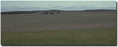 MP50 Landscape |
Soil Profile Morphology:
Surface Soil
| A1 | 0-12 cm | Greyish brown (7.5YR5/4); sand; non-calcareous; pH 7.6: | 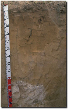 MP50 Profile |
| A2 | 12-40 cm | Brown (7.5YR5/6); sand; non-calcareous; pH 8.9: | |
| Subsoil | |||
| B21 | 40-65 cm | Lightish brown (7.5YR6/6); sand; moderately calcareous; pH 9.2: | |
| B22 | 65-100 cm | Lightish brown (7.5YR6/6); sand; contains a few (5%) soft calcareous segregations; very highly calcareous; pH 9.2: | |
| B23k | 100+ cm | Sand; contains hard calcareous material formed into scattered boulders (60 cm size). | |
Key Profile Features:
- Sandy throughout profile.
- Large carbonate segregations in deeper profile.
Soil Profile Characteristics:
pH | Salinity Rating | |||
Surface (A1 horizon) | Slightly alkaline | Very low | - | - |
Subsoil (B21 horizon) | Very strongly alkaline | Very low | - | - |
Deeper subsoil (at 65-100cm) | Very strongly alkaline | Very low | - | - |
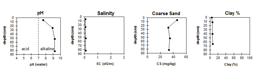
| The soil profile becomes increasingly alkaline with depth. | The level of soluble salts is low throughout the profile. | The coarse sand content is high throughout the profile. | The clay content remains low throughout the soil profile. |
Horizon | Horizon Depth (cm) | pH (water) | pH (CaCl2) | EC 1:5 | Total Nitrogen % | Organic Carbon % | Exchangeable Cations | |||
Ca | Mg | K | Na | |||||||
meq/100g | ||||||||||
A1 | 0-12 | 7.6 | 7 | 0.06 | <0.05 | 0.32 | 1.8 | 0.61 | 0.4 | <0.05 |
A2 | 12-40 | 8.9 | 8.3 | 0.07 | 2.8 | 0.49 | 0.27 | <0.05 | ||
B21 | 40-65 | 9.2 | 8.6 | 0.09 | 4.9 | 0.5 | 0.18 | 0.14 | ||
B22 | 65-100 | 9.2 | 8.6 | 0.09 | 15 | 1.8 | 0.25 | 0.08 | ||
Horizon | Horizon Depth (cm) | Field Capacity pF2.5 | Wilting Point pF4.2 | Coarse Sand (0.2-2.0 mm) | Fine Sand (0.02-0.2 mm) | Silt (0.002-0.02 mm) | Clay (<0.002 mm) |
A1 | 0-12 | 4 | 2 | 46 | 50 | 1 | 4 |
A2 | 12-40 | 6 | 2 | 32 | 62 | 1 | 6 |
B21 | 40-65 | 5 | 2 | 35 | 59 | 1 | 6 |
B22 | 65-100 | 7 | 2 | 33 | 60 | 0 | 7 |
Management Considerations
Whole Profile
- In general, management strategies for all soils should aim to: increase organic matter levels in the surface soil, minimise the degradation of soil aggregates and porosity, promote the development of stable biopores, break up any hardpans, and improve the calcium status of the ion exchange complex. Particularly when sodium plays a significant part i.e. the soil is sodic. Less frequent tillage, using less aggressive implements, and working the soil at optimum moisture conditions can all assist in maintaining soil aggregation and porosity, as well as reducing the breakdown of organic matter.
- Plant available water capacity (PAWC) will be low due to the sandy textured profile. The low wilting point value (2%) in the surface horizons indicates that plants will be able to utilise light rains better than for some of the heavier textured surface soils in the area. However, due to the low water storage capacity, plants will soon suffer moisture stress unless further rainfalls occur.
- The sandy soil profile will have a low nutrient holding capacity and will be well drained throughout.
© State of Victoria (Agriculture Victoria) 1996 - .

This work, Victorian Resources Online, is licensed under a Creative Commons Attribution 4.0 licence. You are free to re-use the work under that licence, on the condition that you credit the State of Victoria (Agriculture Victoria) as author, indicate if changes were made and comply with the other licence terms.
The licence does not apply to ‘branding’ or some ‘images or photographs’ that may be owned by third parties. We ask you to seek prior approval to use images using the VRO feedback form. Access to higher quality images can also be provided on request.
This page was last updated on .