
MP15
| Location: Murrayville. | Australian Soil Classification: Lithocalcic, Subnatric, Red SODOSOL (deep sandy surface). |
| Geology: Quaternary (Woorinen Formation) deposits | General Landscape Description: Crest of dune. |
| Site Description: Cropping paddock (Mallee Research Station cereal cropping and fertiliser trial). | |
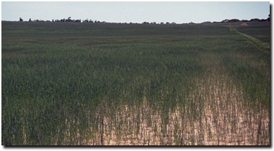 MP15 Landscape |
Soil Profile Morphology:
Surface Soil
| A11 | 0-25 cm | Strong brown (7.5YR5/6); loamy sand; loose surface condition; structureless (single grain); very weak consistence dry; contains a few (2%) hard carbonate fragments (2 cm in size); moderately calcareous; pH 8.8; plough pan layer develops at 15 to 25 cm; moderately calcareous; clear change to: |
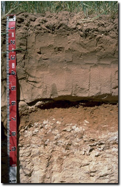 MP15 Profile |
| A12 | 25-35 cm | Dark brown (7.5YR4/4); loamy sand; structureless; very weak consistence dry; pH 9.0; clear change to: | |
| A2 | 35-55 cm | Pink (7.5YR8/4d) conspicuous bleach; sand; massive in structure; very weak consistence dry; pH 9.2; strongly calcareous; sharp and wavy change to: | |
| Subsoil | |||
| B21 | 55-70 cm | Reddish yellow (7.5YR6/6), becoming yellowish red (5YR5/8) with a reddish yellow mottle with depth; sandy clay loam, weakly structured with a hard bleached capping; very firm consistence dry; strongly calcareous; pH 8.9; sharp and wavy change to: | |
| B22 | 70-75 cm | Reddish yellow (7.5YR6/6); medium clay (sandy); pH 9.1; sharp and wavy change to: | |
| C | 75+ cm | Variably layered calcrete. | |
Key Profile Features:
- Deep sandy surface horizons (55 cm deep).
- Strong texture contrast between sandy surface (A) horizons and clayey subsoil.
- Calcrete layer in deeper subsoil.
Soil Profile Characteristics:
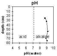 | 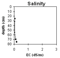 |
| The soil profile is strongly alkaline throughout | The soil profile has a very low salinity rating throughout. |
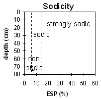 The subsoil is slightly sodic. | |
Horizon | Horizon Depth (cm) | pH (water) | pH (CaCl2) | EC 1:5 | Total Nitrogen % | Organic Carbon % | Exchangeable Cations | |||
Ca | Mg | K | Na | |||||||
Meq/100g | ||||||||||
A11 | 0-25 | 8.8 | 8.1 | 0.08 | <0.05 | 0.23 | 2.6 | 0.6 | 0.4 | 0.3 |
A12 | 25-32 | 9.0 | 8.3 | 0.05 | <0.05 | 0.16 | 2.5 | 0.5 | 0.2 | <0.1 |
A2 | 32-55 | 9.2 | 8.5 | 0.05 | 1.3 | 0.2 | 0.1 | <0.1 | ||
B21 | 55-70 | 8.9 | 8.0 | 0.12 | 6.8 | 4.4 | 0.7 | 0.7 | ||
B22 | 70-75 | 9.1 | 8.3 | 0.18 | 6.5 | 7.0 | 0.9 | 1.1 | ||
Horizon | Horizon Depth | Field Capacity pF2.5 | Wilting Point pF4.2 | Coarse Sand (0.2-2.0 mm) | Fine Sand (0.02-0.2 mm) | Silt (0.002-0.02 mm) | Clay (<0.002 mm) |
A11 | 0-25 | 31 | 2 | ||||
A12 | 25-32 | 3 | 2 | ||||
A2 | 32-55 | 2 | 1 | ||||
B21 | 55-70 | 17 | 9 | 23 | 50 | 0 | 26 |
B22 | 70-75 | 23 | 15 |
Management Considerations
Whole Profile
- In general, management strategies for all soils should aim to increase organic matter levels in the surface soil; minimise the degradation of soil aggregates and porosity; promote the development of stable biopores; improve the calcium status of the ion exchange complex (particularly when sodium is a significant part – i.e. sodic), and break up any hardpans. Less frequent tillage; using less aggressive implements, and working the soil at optimum moisture conditions can all assist in maintaining soil aggregation and porosity as well as reducing the breakdown of organic matter.
- Plant available water capacity (PAWC) is likely to be quite low due to the sandy textured surface horizons and the limited ability of roots to access the subsoil.
- The strongly alkaline profile suggests that phosphorus and some trace elements such as iron, manganese, zinc and copper may be poorly available to plants and deficiencies may occur. Nutrient deficiencies can be assessed by plant tissue analysis. Plant species should be chosen in accordance with this pH level.
- Boron toxicity can also occur in strongly alkaline soils. Boron levels have not been measured at this site.
Surface (A) Horizons
- The surface soil has a high sand content. Soils such as these rely to a large extent on organic matter for maintaining aggregation. Organic matter will build up under pasture but will decline if cultivated. If cropped, practices such as residue retention, minimum tillage and including pasture rotations could be utilised, in order to build up organic matter. Increasing organic matter on such soils is likely to improve soil aggregation, fertility and water holding capacity.
- Surface sands can often be difficult to wet up in this region (due to biologically produced ‘waxes’). It is usually best to work the soil whilst moist.
- The low wilting point values (i.e. 2 %) of the surface horizons indicate that plants will be able to utilise very light rains when the soil is dry. However, due to the low water storage capacity, plants will soon suffer moisture stress unless further rainfalls occur.
- Infiltration of water will be rapid in the surface soil down toward the subsoil. The presence of a conspicuous bleach in the subsurface (A2) horizon is a symptom of the restricted permeability of the subsoil. It indicates that periodic waterlogging occurs above this more slowly permeable subsoil. The strongly leached A2 horizon has a very low inherent fertility. Planting legumes can help to increase fertility.
Subsoil (B) Horizon
- The dense upper subsoil has a hard capping which is likely to restrict root and water movement. The subsoil is also sodic and disperses which indicates that root and water movement will be restricted as the subsoil swells when saturated. Introducing more calcium (via gypsum) into the system may help ameliorate this problem. However, due to the depth to this layer (55 cm from the surface), gypsum application may not be economically viable.
© State of Victoria (Agriculture Victoria) 1996 - .

This work, Victorian Resources Online, is licensed under a Creative Commons Attribution 4.0 licence. You are free to re-use the work under that licence, on the condition that you credit the State of Victoria (Agriculture Victoria) as author, indicate if changes were made and comply with the other licence terms.
The licence does not apply to ‘branding’ or some ‘images or photographs’ that may be owned by third parties. We ask you to seek prior approval to use images using the VRO feedback form. Access to higher quality images can also be provided on request.
This page was last updated on .