
MP42
| Location: Nullawil. | Australian Soil Classification: Epihypersodic, Pedal, Hypercalcic, CALCAROSOL (loamy surface). |
| Geology: Quaternary alluvial & aeolian deposits. | General Landscape Description: Level plain with gilgai microrelief. |
| Site Description: Cropping paddock (with barley stubble). |
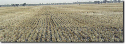 Site MP42 Landscape |
Soil Profile Morphology:
Surface Soil
| Ap | 0-5 cm | Brown (7.5YR4/2); sandy clay loam; soft surface condition; weak-moderate medium to fine polyhedral structure; very weak to weak consistence (dry); moderately calcareous; pH 8.4; sharp change to: | 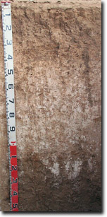 Site MP42 Profile |
| Subsoil | |||
B21 | 5-15 cm | Brown (7.5YR4/4); sandy clay; weak-moderate very coarse prismatic, parting to weak-moderate coarse to medium blocky structure; very firm consistence (dry); moderately calcareous; pH 8.7; clear change to: | |
B22 | 15-30 cm | Brown (7.5YR4/4); sandy clay; weak-moderate very coarse prismatic structure; firm to very firm consistence (dry); moderately calcareous; pH 8.7; clear change to: | |
B23k | 30-45 cm | Yellowish red (5YR5/6); light medium clay (sandy); weak-moderate very coarse prismatic structure; firm to very firm consistence (dry); fine-earth carbonates common (20%); pH 9.4; gradual change to: | |
B24k | 45-110 cm | Reddish yellow (5YR6/6); light medium clay (sandy); weak-moderate coarse to medium polyhedral structure; firm consistence (dry); very many (80%) fine-earth carbonates; pH 10.0; clear and irregular change to: | |
B25k | 110-130 cm | No sample taken. | |
B3 | 130+ cm | Light brownish grey (2.5Y6/2) with many (40%) reddish brown (5YR5/4) mottles; medium heavy clay; strong coarse to medium polyhedral structure (smooth-faced peds); few (5%) manganese flecks; pH 9.6. |
Key Profile Features:
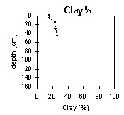
- Gradual increase in texture (clay content) with depth down the soil profile.
- Very many fine-earth carbonates in deeper subsoil.
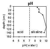
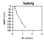
pH | Salinity Rating | |||
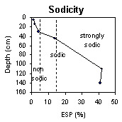
Surface (Ap horizon) | Moderately Alkaline | Low | Non-Sodic | None |
Subsoil (B21 horizon) | Strongly Alkaline | Low | Non-Sodic | None |
Deeper subsoil (at 45-110 cm) | Very Strongly Alkaline | High | Strongly Sodic | Moderate |
 |  |  | |
 | 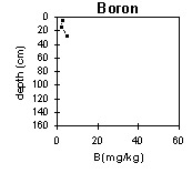 |
Horizon | Horizon Depth (cm) | pH (water) | pH (CaCl2) | EC 1:5 | NaCI % | Exchangeable Cations | Boron (CaCl2) mg/kg | Field Capacity pF2.5 | Wilting Point pF4.2 | Coarse Sand (0.2 - 2.0 mm) | Fine Sand (0.02 -0.2 mm) | Silt (0.002 -0.02 mm) | Clay (<0.002 mm) | |||
Ca | Mg | K | Na | |||||||||||||
meq/100g | ||||||||||||||||
Ap | 0-5 | 8.4 | 8.0 | 0.22 | 24 | 2.9 | 2.4 | 0.22 | 2.6 | 21 | 10 | 37 | 27 | 15 | 16 | |
B21 | 5-15 | 8.7 | 8.2 | 0.23 | 27 | 5.4 | 1.6 | 0.58 | 2.4 | 27 | 14 | 31 | 24 | 18 | 23 | |
B22 | 15-35 | 8.7 | 8.2 | 0.35 | <0.01 | 17 | 7.2 | 1.5 | 1.0 | 27 | 15 | 35 | 20 | 13 | 24 | |
B23k | 35-45 | 9.4 | 8.6 | 0.40 | 0.03 | 9.3 | 9.2 | 0.9 | 3.0 | 5 | 29 | 15 | 31 | 18 | 5 | 26 |
B24k | 45-110 | 10 | 9.1 | 0.93 | 0.11 | 2.1 | 8.1 | 1.3 | 8.1 | 31 | 16 | |||||
B25k | 110-130 | |||||||||||||||
B3 | 130+ | 9.6 | 9.5 | 1.3 | 0.07 | 2.4 | 13 | 2.1 | 12 | |||||||
Notes: Most roots observed to 40 cm depth.
Profile Described By: Mark Imhof, April 2004.
© State of Victoria (Agriculture Victoria) 1996 - .

This work, Victorian Resources Online, is licensed under a Creative Commons Attribution 4.0 licence. You are free to re-use the work under that licence, on the condition that you credit the State of Victoria (Agriculture Victoria) as author, indicate if changes were made and comply with the other licence terms.
The licence does not apply to ‘branding’ or some ‘images or photographs’ that may be owned by third parties. We ask you to seek prior approval to use images using the VRO feedback form. Access to higher quality images can also be provided on request.
This page was last updated on .