
MP41
| Location: Nullawil. | Australian Soil Classification: Bleached-Sodic, Calcic, Grey, DERMOSOL (clayey surface). |
| Geology: Quaternary alluvial & aeolian sediments. | General Landscape Description: Level plain (floodplain of Tyrell Creek). |
| Site Description: Cropping paddock. |
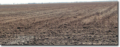 Site MP41 Landscape |
Soil Profile Morphology:
Surface Soil
| Ap | 0-8 cm | Very dark greyish brown (10YR3/2); light clay; soft surface condition; weak consistence (dry); pH 7.4: | 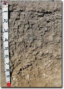 Site MP41 Profile |
| A12 | 8-10 cm | Brown (10YR5/3) conspicuously bleached (10YR7/1 dry); heavy sandy clay loam; firm consistence (dry); pH 8.1: | |
| Subsoil | |||
| B21 | 10-30 cm | Light brownish grey (10YR6/2) with few (5%) faint brownish yellow (10YR6/6) mottles; medium clay; moderate coarse prismatic, parting to strong coarse to medium blocky structure; strong consistence (dry); pH 8.3: | |
| B22 | 30-50 cm | Greyish brown (10YR5/2); medium heavy clay; strong coarse to medium blocky structure; strong consistence (dry); few (5%) medium (3-10 mm) calcareous nodules; pH 9.4: | |
| B23k | 50-80 cm | Reddish yellow (7.5YR7/6); medium heavy clay; fine-earth carbonates and calcareous nodules common (15%); pH 9.8: | |
| B24k | 80-100 cm | Reddish yellow (7.5YR7/6); medium clay; fine-earth carbonates common (15%); pH 9.8: | |
| B25 | 100-140 cm | Reddish yellow (7.5YR7/6); medium clay; very few (2%) manganese stains; pH 9.8. |
Key Profile Features:
- Lack of strong texture contrast between surface (A) horizons and subsoil (B21) horizon.
- Clayey surface horizons.
- Fine-earth carbonates common in deeper subsoil.
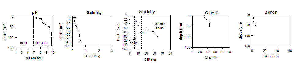
pH | Salinity Rating | |||
Surface (Ap horizon) | Slightly Alkaline | Low | Non-Sodic | None1 |
Subsoil (B21 horizon) | Strongly Alkaline | Low | Sodic | Moderate |
Deeper subsoil (at 100-140 cm) | Very Strongly Alkaline | Very High | Strongly Sodic | strong |
 | ||||
Horizon | Horizon Depth (cm) | pH (water) | pH (CaCl2) | EC 1:5 | NaCI % | Exchangeable Cations | Boron (CaCl2) mg/kg | Field Capacity pF2.5 | Wilting Point pF4.2 | Coarse Sand (0.2 - 2 mm) | Fine Sand (0.02 - 0.2 mm) | Silt (0.002 - 0.02 mm) | Clay (<0.002 mm) | |||
Ca | Mg | K | Na | |||||||||||||
meq/100g | ||||||||||||||||
Ap | 0-8 | 7.4 | 6.9 | 0.24 | 12 | 5.3 | 1.6 | 0.85 | 2.3 | 24 | 13 | 25 | 28 | 9 | 32 | |
A2 | 8-10 | 8.1 | 7.2 | 0.13 | 9.2 | 4.3 | 0.68 | 0.92 | 1.7 | 22 | 11 | 28 | 27 | 11 | 32 | |
B21 | 10-30 | 8.3 | 7.4 | 0.16 | 13 | 7 | 0.98 | 1.7 | 2.5 | 31 | 16 | 22 | 20 | 9 | 46 | |
B22 | 30-50 | 9.4 | 8.4 | 0.25 | 18 | 8.7 | 1.1 | 3.3 | 5.6 | 39 | 18 | 23 | 19 | 7 | 46 | |
B23k | 50-80 | 9.8 | 9.5 | 0.44 | <0.01 | 6.4 | 11 | 1.4 | 7.7 | 47 | 20 | |||||
B24k | 80-100 | 9.8 | 9.4 | 0.52 | 0.01 | 5.4 | 11 | 1.4 | 9.0 | |||||||
B25 | 100-140 | 9.8 | 9.5 | 0.62 | 0.03 | |||||||||||
Profile Described By: Mark Imhof, April 2004.
© State of Victoria (Agriculture Victoria) 1996 - .

This work, Victorian Resources Online, is licensed under a Creative Commons Attribution 4.0 licence. You are free to re-use the work under that licence, on the condition that you credit the State of Victoria (Agriculture Victoria) as author, indicate if changes were made and comply with the other licence terms.
The licence does not apply to ‘branding’ or some ‘images or photographs’ that may be owned by third parties. We ask you to seek prior approval to use images using the VRO feedback form. Access to higher quality images can also be provided on request.
This page was last updated on .