
MP26
| Group: Birchip Cropping Group. | Location: Curyo. |
| Australian Soil Classification: Hypercalcic, Mesonatric, Red SODOSOL. | |
| General Landscape Description: Low rise (possibly a lunette) on a plain within the Culgoa Land System (Rowan and Downes, 1963). | |
Soil Profile Morphology:
Surface Soil
| A1 | 0-10 cm | Dark brown (7.5YR4/4); light sandy clay loam; massive and hardsetting; firm consistence dry; pH 8.6; sharp change to: | 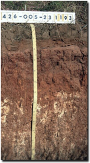 Site MP26 Profile |
| A2 | 10-20 cm | Brown (7.5YR4/6); light sandy loam; massive; weak to firm consistence dry; thin bleached layer occurs at the interface with the subsoil; pH 8.4; sharp change to: | |
| Subsoil | |||
| B21 | 20-40 cm | Yellowish red (5YR5/8); light medium clay (sandy); moderate coarse to very coarse prismatic structure; pH 9.6: | |
| B22 | 40-60 cm | Reddish yellow (5YR6/8); medium clay; moderate coarse prismatic structure; very firm consistence dry; pH 8.9; gradual change to: | |
| B23k | 60-160 cm | Reddish yellow (7.5YR6/6); light medium clay; moderate medium prismatic structure; strong consistence dry; contains many (20-30%) fine earth carbonate segregations, hard carbonate nodules and some ironstone fragments common (10-20%); pH 9.8; gradual change to: | |
| B31 | 160 cm+ | Reddish yellow (7.5YR6/6); medium heavy clay; strong medium prismatic structure (smooth-faced peds); strong consistence dry; contains a zone of soft manganese segregations at 160-165 cm; pH 6.8. | |
Soil Profile Characteristics:
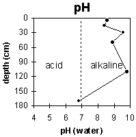
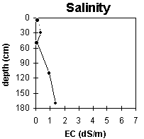
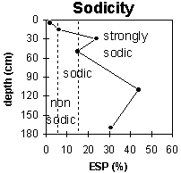
pH | Salinity Rating | |||
Surface (A1 horizon) | strongly alkaline | very low | non-sodic | none |
Subsoil (B21 horizon) | extremely alkaline | low | strongly sodic | strong |
Deeper subsoil (at 1 m) | extremely alkaline | medium-high | very strongly sodic | slight-moderate |
 |  |  |
Horizon | Horizon Depth (cm) | pH (water) | pH (CaCl2) | EC 1:5 | NaCI % | Exchangeable Cations | Field Capacity pF 2.5 | Wilting Point pF 4.2 | Coarse Sand (0.2 - 2.0 mm) | Fine Sand (0.02 -0.2 mm) | Silt (0.002 -0.02 mm) | Clay (<0.002 mm) | |||
Ca | Mg | K | Na | ||||||||||||
meq/100g | |||||||||||||||
A1 | 0-10 | 8.6 | 7.9 | 0.09 | 14.6 | 2.7 | 1.9 | 0.3 | 23 | 8 | 36 | 31 | 4 | 23 | |
A2 | 10-20 | 8.4 | 7.9 | <0.05 | 5.9 | 1.2 | 0.2 | 0.5 | 15 | 3 | |||||
B21 | 20-40 | 9.6 | 8.6 | 0.34 | <0.05 | 5.8 | 10.3 | 0.8 | 5.2 | 37 | 16 | 32 | 26 | 2 | 36 |
B22 | 40-60 | 8.9 | 7.6 | 0.08 | 6.8 | 5.4 | 0.5 | 2.2 | 28 | 12 | |||||
B23k | 60-160 | 9.8 | 8.9 | 0.92 | 0.12 | 2.6 | 8 | 0.9 | 9.1 | 38 | 16 | ||||
B31 | 160+ | 6.8 | 6.4 | 1.38 | 0.25 | 3.4 | 8.7 | 0.8 | 5.7 | ||||||
Management Considerations:
General
- Management strategies for all soils should aim to increase organic matter levels in the surface soil; minimise the degradation of soil aggregates and porosity; promote the development of stable biopores; improve the calcium status of the cation exchange complex (particularly when sodium is a significant part), and break up any hardpans. Less frequent tillage, using less aggressive implements, and working the soil at optimum moisture content can all assist in maintaining soil aggregation and porosity as well as reducing the breakdown of organic matter.
- The upper surface soil is strongly alkaline which indicates that phosphorus and some trace elements (e.g. iron, manganese, copper and zinc) may be poorly available to plants.
- The hardsetting surface horizon requires organic matter for maintaining soil aggregation.
- The strongly sodic and dispersive subsoil is coarsely structured and likely to significantly restrict root and water movement down the profile.
- A medium to high level of soluble salts occur from 80 cm in the soil profile and is likely to affect the growth of salt-sensitive species (e.g. lucerne, faba beans and linseed).
- The subsoil is extremely alkaline which indicates that phosphorus and some trace elements (e.g. iron, manganese, copper and zinc) may be poorly available to plants.
© State of Victoria (Agriculture Victoria) 1996 - .

This work, Victorian Resources Online, is licensed under a Creative Commons Attribution 4.0 licence. You are free to re-use the work under that licence, on the condition that you credit the State of Victoria (Agriculture Victoria) as author, indicate if changes were made and comply with the other licence terms.
The licence does not apply to ‘branding’ or some ‘images or photographs’ that may be owned by third parties. We ask you to seek prior approval to use images using the VRO feedback form. Access to higher quality images can also be provided on request.
This page was last updated on .