
LWA21
| Location: Birchip | |
| Australian Soil Classification: Vertic (& Endohypersodic), Pedal, Hypercalcic CALCAROSOL (clay loamy surface soil) | |
| General Landscape Description: Level Plain | Site Description: No-till paddock of demonstration site |
| Geology: Quaternary aeolian and alluvial deposits | |
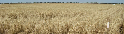 LWA 21 Landscape |
Soil Profile Morphology:
Surface Soil
| A11 | 0-12 cm | Brown (7.5YR4/2); clay loam; weak to moderate medium (10-20 mm) sub-angular blocky, parting to weak to moderate fine (5-10 mm) polyhedral structure; very weak consistence (moderately moist); moderately calcareous effervescence fine earth; abrupt change to: | 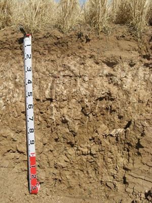 LWA 21 Profile |
| A21 | 12-18 cm | Brown (7.YR4/3); light clay (-); massive; uncemented cultivation pan, parting to moderate fine (5-10 mm) polyhedral structure; very weak consistence (moderately moist); moderately calcareous effervescence fine earth; abrupt change to: | |
| Subsoil | |||
| B21 | 18-32 cm | Reddish brown (5YR5/4) with reddish brown (5YR4/3) and light brown (7.5YR6/4) mottles; light-medium clay; weak medium (20-50 mm) prismatic, parting to weak fine (10-20 mm) prismatic and weak fine (5-10 mm) polyhedral structure; weak consistence (moderately moist); high calcareous effervescence fine earth; clear change to: | |
| B22k | 32-45 cm | Brown (7.5YR5/4) with brown (7.5YR4/2) and strong brown (7.5YR4/6) mottles; medium clay; weak coarse (50-100 mm) prismatic, parting to weak coarse (20-50 mm) angular blocky structure; weak consistence (moderately moist); highly effervescent fine-earth; many (20-50%) soft calcareous segregations; gradual change to: | |
| B23 | 45-80 cm | Brown (7.5YR5/4) with yellowish red (5YR5/6) and light grey (2.5YR7/2) mottles; medium clay; strong coarse (50-100 mm) prismatic, parting to strong medium (20-50 mm) prismatic and angular blocky structure; very firm consistence (dry); many (20-50%) soft calcareous segregations and few (2-10%) calcareous nodules with very few (<2%) soft manganiferous segregations; gradual change to: | |
| B24 | 80-100 cm | Yellowish brown (10YR5/4) with yellowish red (5YR5/6) and light yellowish brown (2.5Y6/3) mottles; medium-heavy clay; weak coarse (50-100 mm) prismatic, parting to moderate (20-50 mm) prismatic structure; firm consistence (moderately moist); few (2-10%) soft manganiferous segregations; few distinct slickensides; diffuse change to: | |
| B25 | 100-140 cm | Brown (7.5YR4/2) with light yellowish brown (2.5Y6/3) and olive grey (5Y5/2) mottles; medium-heavy clay; moderate (20-50 mm) prismatic structure; firm consistence (moderately moist), very few (<2%) soft manganiferous segregations; common distinct slickensides. | |
Key Profile Features:
- Gradual increase in texture (i.e. clay content) with depth down the soil profile.
- Calcareous throughout (with zone of many calcareous segregations in upper soil profile)
Soil Profile Characteristics:
pH | Salinity Rating | |||
Surface (A1 horizon) | Strongly alkaline | Low | Non-sodic | None |
Subsoil (B21 horizon) (18-32 cm) | Very strongly alkaline | Low | Sodic | None 1 |
Deeper subsoil (at 110-140 cm) | Very strongly alkaline | Very high | Strongly sodic | Moderate |
- 1 moderate dispersion after remoulding
Horizon | Horizon Depth | pH (water) | pH CaCl2 | EC 1:5 | NaCl | Exchangeable Cations | |||
Ca | Mg | K | Na | ||||||
Meq/100g | |||||||||
A11 | 0-12 | 8.7 | 8.1 | 0.17 | 29 | 6.1 | 1.8 | 0.42 | |
A21 | 12-18 | 9 | 8.3 | 0.17 | 28 | 7.4 | 0.98 | 0.99 | |
B21 | 18-32 | 9.5 | 8.5 | 0.29 | <0.02 | 8.6 | 9.7 | 0.76 | 3.1 |
B22k | 32-45 | 9.8 | 8.8 | 0.64 | 4.1 | 11 | 0.79 | 6.2 | |
B23 | 45-80 | 9.9 | 9.1 | 1 | 0.13 | 2.2 | 12 | 1.1 | 11 |
B24 | 80-100 | 9.8 | 9 | 1.3 | 0.18 | 2.1 | 13 | 1.3 | 13 |
B25 | 100-140 | 9.5 | 8.8 | 1.6 | 0.26 | 2.5 | 12 | 1.2 | 13 |
Horizon | Horizon Depth | Boron mg/kg | Field pF2.5 g/100g | Wilting Point pF4.2 g/100g | Coarse Sand (0.2-2.0mm) % | Fine Sand (0.02-0.2mm) % | Silt (0.002-0.02mm) % | Clay (<0.002mm) % |
A11 | 0-12 | 2.2 | 32.2 | 13.7 | 30 | 20 | 6 | 30 |
A21 | 12-18 | 2.9 | 34.7 | 13.9 | 29 | 21 | 5 | 29 |
B21 | 18-32 | 3.9 | 34.1 | 17.8 | 27 | 18 | 3 | 30 |
B22k | 32-45 | 9.2 | 35.7 | 18.7 | 25 | 16 | 4 | 29 |
B23 | 45-80 | 24 | 38.7 | 18.5 | 26 | 17 | 13 | 31 |
B24 | 80-100 | 32 | 44.7 | 21.7 | ||||
B25 | 100-140 | 25 |
Management Considerations:
Whole Profile
- In general, management strategies for all soils should aim to increase organic matter levels in the surface soil, minimise the degradation of soil aggregates and porosity, promote the development of stable biopores, improve the calcium status of the ion exchange complex (particularly when sodium is a significant part) and break up any hardpans. Less frequent tillage, using less aggressive implements and working the soil at optimum moisture conditions can all assist in maintaining soil aggregation and porosity, as well as, reducing the breakdown of organic matter.
- Tillage of clayey soils like these should be avoided if the soil is wet (i.e. wetter than the plastic limit). At such moisture conditions, excessive tillage, trafficking or over-stocking could result in some structural damage (e.g. compaction). Ideally, tillage should take place on clayey soils when the soil is drier than the plastic limit – down to at least the tillage depth.
- The subsoil is very strongly to extremely alkaline throughout. This indicates that some nutrients (e.g. iron, manganese, zinc, copper) may be poorly available to plants and that deficiencies are likely to occur. Deficiencies should be determined by plant tissue analysis.
- The subsoil has a high level of soluble salts in the deeper subsoil (from 45 cm depth) that will restrict the growth of deeper rooted salt-sensitive species.
- Boron toxicity can also occur in strongly alkaline soils. Boron levels increase in the very strongly alkaline subsoil (from 30 cm depth) to levels which may affect the growth of boron-sensitive species including cereals, pulses, pasture legumes. At this site, boron levels are reasonably high (i.e. > 24 mg/kg) in the deeper subsoil. Concentrations as low as 10 ppm, for example, can reduce lentil yield. Although there is limited data it is estimated that the threshold level of soluble boron for cereals is 15 mg/kg (Cartwright et al., 1984). Previous work at DPI, Horsham has indicated that where there are low levels of soluble salts boron tolerance can be comparatively high, with little reduction in wheat yield at levels of up to 45 ppm (Quinlan, 2001).
- The upper subsoil (18-32 cm) is sodic, but does not disperse unless remoulded. It is also reasonably well structured – parting to fine polyhedral peds. This indicates that root and water movement will not be significantly restricted in the upper subsoil. However, the more coarsely structured deeper subsoil becomes strongly sodic and more dispersive – indicating that root and water movement will be restricted at depth.
- Soil profile described by Melissa Cann (May 2007)
© State of Victoria (Agriculture Victoria) 1996 - .

This work, Victorian Resources Online, is licensed under a Creative Commons Attribution 4.0 licence. You are free to re-use the work under that licence, on the condition that you credit the State of Victoria (Agriculture Victoria) as author, indicate if changes were made and comply with the other licence terms.
The licence does not apply to ‘branding’ or some ‘images or photographs’ that may be owned by third parties. We ask you to seek prior approval to use images using the VRO feedback form. Access to higher quality images can also be provided on request.
This page was last updated on .