
MP4b
| Location: Walpeup. | Australian Soil Classification: Epibasic (and Epihypersodic), Pedal, Hypercalcic, CALCAROSOL. |
| Northcote Factual Key: Gc 2.22. | Great Soil Group: solonized brown soil. |
| Geology: Quaternary deposits (Woorinen Formation). | General Landscape Description: Open depression of a swale. |
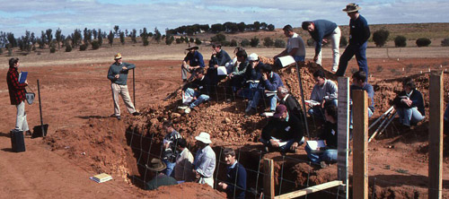
| MP4b Landscape |
Soil Profile Morphology:
Surface Soil
| A11 | 0-3 cm | Dark reddish brown (2.5YR3/4) sandy loam; surface pavement has a layer of a few (2-10%) hard carbonate nodules; weakly structured (massive); firm consistence dry; non calcareous; pH 7.8; sharp change to: |
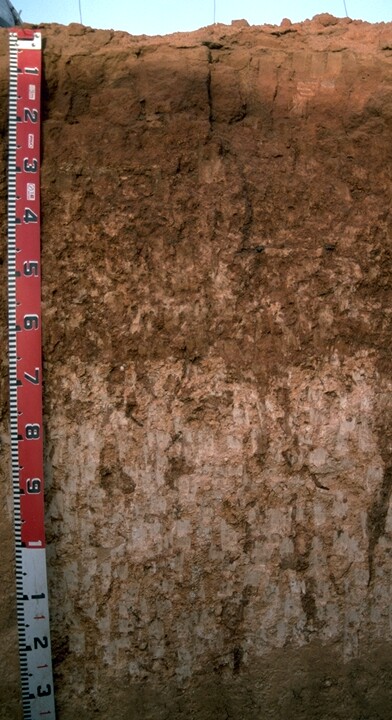 MP4b Profile |
| A12 | 3-18 cm | Dark red (2.5YR3/6); light sandy clay loam; weakly structured (massive); firm consistence dry; non calcareous; pH 8.1; sharp change to: | |
| Subsoil | |||
| B21k | 18-70 cm | Red (2.5YR4/6); sandy clay loam (becoming sandy clay with depth); moderate medium sub-angular blocky structure (rough-faced peds); strong consistence dry; fine-earth carbonates common (10-20%); highly calcareous; pH 9.6; gradual change to: | |
| B22k | 70-150 cm | Red (2.5YR4/8); sandy clay; moderate medium sub-angular blocky structure; firm consistence dry; contains very many (80%) fine-earth carbonates and hard calcareous nodules (3-50 mm in size); very highly calcareous; pH 9.9; clear change to: | |
| B23k | 150-230 cm | Red (2.5YR4/8); medium clay (sandy); moderate medium sub-angular blocky structure; strong consistence dry; contains tongues of soft carbonate; contains at 200 cm depth heavy clay ‘pipe’ structures with a few (2-10%) manganese nodules; very highly calcareous; pH 9.5; clear change to: | |
| B3 | 230-300 cm | Red (2.5YR4/6) with yellowish red (5YR5/8) and subdominant light yellowish brown (10YR6/4); medium clay; strong fine to medium angular blocky structure (smooth-faced peds); strong consistence dry; contains a few (<2%) soft fine segregations (manganese); slickensides present; highly calcareous; pH 8.4. | |
Key Profile Features:
- The surface (A11 layer) is largely anthropogenic (i.e. exhibits horizontal banding).
- There is a gradual increase in clay content at the A/B horizon interface.
- The profile has a high sand content.
- The upper subsoil horizons have large amounts of carbonate (i.e. hypercalcic).
- The deep subsoil (from 230 cm depth) represents an older Quaternary (K4) land surface. This horizon has vertic properties (i.e. slickensides present).
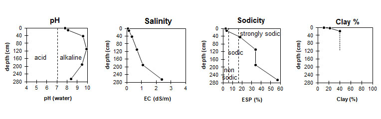
| The surface soil is slightly alkaline and the subsoil is extremely alkaline. | The surface soil has a low salinity rating. The upper subsoil has a moderate rating and the deeper subsoil is high. |
|
|
Management Considerations:
Surface (A) Horizon
- In general, management strategies for all soils should aim to increase organic matter levels in the surface soil; minimise the degradation of soil aggregates and porosity; promote the development of stable biopores; improve the calcium status of the ion exchange complex (particularly when sodium is a significant part – i.e. sodic), and break up any hardpans. Less frequent tillage; using less aggressive implements, and working the soil at optimum moisture conditions can all assist in maintaining soil aggregation and porosity as well as reducing the breakdown of organic matter. Practices such as residue retention, minimum tillage and including pasture rotations could be utilised if cropping takes place in order to build up organic matter, reduce erosion risk and increase the soils low inherent fertility.
- The subsoil is extremely alkaline. This indicates that some nutrients (e.g. iron, manganese, zinc, copper) may be poorly available to plants and that deficiencies are likely to occur. Deficiencies should be determined by plant tissue analysis.
- Boron toxicity can also occur in strongly alkaline soils. Boron levels were not measured, however, at this site.
- The subsoil becomes strongly sodic at 40 cm depth and has a low exchangeable calcium to magnesium ratio (i.e. <1). Strong dispersion after remoulding occurs as a result. These conditions are likely to result in restricted root and water movement in the subsoil. With the increase of salt levels going down the profile, however, the dispersion decreases accordingly.
- The salinity rating becomes moderate at about 40 cm depth and increases to a high level at about 80 cm. These levels of soluble salts are likely to restrict the growth of salt-sensitive plant species (e.g. faba beans, linseed, chick peas and lupins).
- The deeper subsoil displays strong vertic properties (i.e. slickensides) which indicates that significant shrinking and swelling occurs with drying and wetting cycles. This may disturb the roots of some plant species and has engineering implications (e.g. disturbance to building foundations and fence lines.
© State of Victoria (Agriculture Victoria) 1996 - .

This work, Victorian Resources Online, is licensed under a Creative Commons Attribution 4.0 licence. You are free to re-use the work under that licence, on the condition that you credit the State of Victoria (Agriculture Victoria) as author, indicate if changes were made and comply with the other licence terms.
The licence does not apply to ‘branding’ or some ‘images or photographs’ that may be owned by third parties. We ask you to seek prior approval to use images using the VRO feedback form. Access to higher quality images can also be provided on request.
This page was last updated on .