
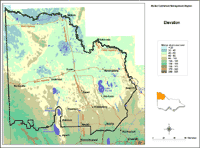
Elevation
|
This elevation map provides a broadscale overview of the relief across the region. It was created from the DEM250 dataset in the DSE Corporate Geospatial Data Library. This in turn was derived from an AUSLIG Digital Elevation Model of spot heights from 1:100 000 mapsheets and interpolated into a 500 metre cell size grid. |
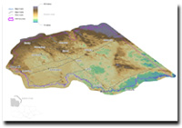
Mallee 3D Elevation
© State of Victoria (Agriculture Victoria) 1996 - .

This work, Victorian Resources Online, is licensed under a Creative Commons Attribution 4.0 licence. You are free to re-use the work under that licence, on the condition that you credit the State of Victoria (Agriculture Victoria) as author, indicate if changes were made and comply with the other licence terms.
The licence does not apply to ‘branding’ or some ‘images or photographs’ that may be owned by third parties. We ask you to seek prior approval to use images using the VRO feedback form. Access to higher quality images can also be provided on request.
This page was last updated on .