
Nelson Land System
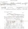 | Nelson Land System - Figures19-20 (PDF - 521KB) To view the information PDF requires the use of a PDF reader. This can be installed for free from the Adobe website (external link). |
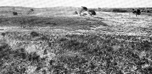 Plate 8. The limestone dunes of the Nelson land-system were among the earliest land to have been farmed in south-western Victoria | The Nelson land-system is associated with the limestone dunes of the coastal plains and the less-acid sands derived from them. In general, the indurated calcareous dunes are adjacent to the present coastline except to the west of the Kainawinka-Kentbruck line of faults. Consequently the Nelson land-system is formed as a thin strip next to the coastal dunes, namely the Discovery Bay land-system, westward as far as Kentbruck where it then expands inland over the coastal plains. In South Australia, the land-system is extensive and comprises the Caroline, Burrungule, Benara and Woakwine Associations mapped by Blackburn (1959). In Victoria, it covers about 180,000 acres; 74,000 acres remain with the Crown including about 54,000 acres of Forests Commission holdings. |
Climate
Most parts of the land system are in a wet climate. The average annual rainfall varies from 35 inches in the parish of Kentbruck to 29 inches at Nelson with an isolated part at Kaladbro receiving 27 inches, but in most areas it exceeds 30 inches. Moreover, the seasonal fluctuation of the rainfall is not so severe as over most other areas nor are the seasonal temperatures so extreme. This is because much of the land-system is near the coast or fringes the south-western edge of the Normanby Platform, receives the highest summer rainfall. The effect of these features on the balance of potential evapo-transpiration with rainfall and on the vigour of plant growth is such that over most of the land-system the season of active growth, particularly, for deep-rooted species, is longer than it is elsewhere in most of the survey area. The favourable growing conditions at Portland as shown for some species in Fig. 9 probably apply to much of the Nelson land-system. There is one adverse feature, however, namely the high winds which make local conditions much more severe near the coast, especially along the Bridgewater fault.
Parent Material
(i) Range encountered. - Indurated calcareous dunes are characteristically associated with the
land-system and present over most of it. They may be exposed at the surface or may form a core underneath a mantle of sand.
It seems that originally, the indurated dunes were similar to the dunes forming now in the Discovery Bay land-system, that is, often of' grand dimensions and of sand composed of finely-broken-down seashells with a small proportion of quartz grains. The original composition and shape of the dunes have been modified by weathering and the main process has been the dissolving, downward removal and re-deposition of the calcium carbonate composing the sea-shells. Such a process has resulted in a general reduction of the surface level, a mild degree of cementation with calcium carbonate in the deeper layers of the dune, strong cementation and the formation of a massive hardpan in a zone nearer the surface, and finally in a residual sandy surface-horizon progressively less of carbonate and more of quartz. The sand of the Discovery Bay dunes has a content of quartz grains such that the weathering of about fourteen feet of material is necessary to produce a quartzitic sandy horizon three feet thick such as is found in the Nelson land-system. Removal of the surface sand by wind erosion during some later period has left calcareous dunes which are case-hardened or indurated by a massive hardpan of limestone, whilst the re-distributed surface material has formed the associated dunes and sheets of sand. In some places the indurated dunes have been further modified by weathering which produces sink-holes and swales.
The topography of the exposed indurated dunes is rolling. Re-distributed sands form dunes particularly near their presumed source, and sometimes form sand-sheets particularly at a distance from the source; their topography therefore varies from rolling to gently undulating. Their colour varies from red through brown and orange to light yellowish-brown and white; orange and white predominate, the sands of the latter colour being mapped as separate land-systems. In general, sands of the brighter colours, red and orange, are most closely associated with the indurated calcareous dunes and also have the most rolling topography whereas sands of the duller and lighter colours are furthest away and have the more gentle topography. Also, in examples examined microscopically, the content of broken-down shells in the sand-fraction varies through the sequence red-orange-white sands, being approximately 10 per cent, occasional and negligible respectively.
Land-forms less commonly found in the land-system are parallel small dunes or raised beaches formed by recent rises in sea-level of about twenty to thirty feet and also of about five feet above the present level. (Coulson 1940, Boutakoff 1963). Around Narrawong near Portland such beaches composed of broken shells and sand have been mapped as the Allestree land-unit.
(ii) Geographical sequence. - The parent materials described above are frequently found in zones parallel to the coast line which is transverse to the prevailing southwesterly winds, for most of the land-system. The complete sequence, including areas of sands mapped as other land-systems, consists of five zones.
Thus, along the coast, there may be found unconsolidated calcareous sands composing the Discovery Bay land-system. This is zone one, which in places directly abuts onto the Nelson land-system or is separated from it by the Long Swamp land-system. The second zone is the seaward fringe of the Nelson land-system, where the indurated calcareous dunes are at or very near the surface.
A short distance further inland there are orange and brown sands and a few areas of red sand. At first these sands are found only in the more sheltered spots such as the lee side of saddles and on lower slopes, but a little further inland they are also on the shoulders and summits of hills until, at a little distance from the zone of exposed limestone, the whole landscape is mantled with these sands. This is zone three. The sequence from zone two to zone three may be readily observed from the presence of bracken, which thrives on orange, brown or red sands more than about 12 inches thick but is sparse or absent on the shallow and more alkaline soils of the exposed limestone. Although the separation of the two zones is most noticeable along the coastal strip, a similar situation often occurs with any indurated calcareous dune which is far enough away from similar dunes to avoid complication by extraneous material. Thus, at both Malanganee and Kaladbro, the narrow strip of bare dune-limestone is on the south-western side of a zone of orange and brown sands. However, where indurated calcareous dunes occur close together or the area of dune limestone is wide, then the segregation of zones is less marked and there is a complex consisting mainly of overlying sands with some areas of exposed limestone.
On the leeward, landward side of the zone of orange sands, there are nearly always areas of "white" or grey sands, the Malangance sands which form zone five. Areas of these acid white sands large enough to be mapped separately have been mapped as the Follett or Kanawinka land-systems, but small areas occur in the Nelson and other land-systems. Frequently, the transition from zone three to five is sharp and precise. Sometimes however, there is between them an extent of sands with intermediate characteristics, forming zone four.
A sequence virtually identical to this has been described from the Swan Coastal Plain near Perth, Western Australia, by Bettenay, MacArthur and Hingston (1960), who separate the Quindalup, Cottesloe, Karrakatta and Bassendean Associations, progressively further inland from the coast. These Associations seem to correspond with zones one, two, three and five respectively. The sequence in Victoria is almost certainly the result of successive stripping of soils formed on the dune limestones, probably at quite widely different times, and the resultant sand deposits have been subjected to different regimes of climate, different periods of time, or both.
(ii) Basis of subdivision of land-system. - The characteristic sequence across the land-system described in the fast paragraph forms the basis of subdivision.
On the exposed, indurated calcareous dunes, zone two, is the Bridgewater sub-system and includes the Bridgewater, Eurneralla and Nelson land-units, totalling 22,800 acres. The greater part of the zone of orange and brown sands is the Kentbruck sub-system and has only one land-unit, the Kentbruck land-unit covering 51,600 acres. Areas where there is a complex of orange and brown sands with some exposed indurated dunes compose the William sub-system of 72,000 acres extent and include the William, Donald, Dartmoor and Kaladbro land-units. The only occurrence of zone four is the Moleside land-unit which comprises the Moleside sub-system. Areas where there is a complex of dunes or sheets of the sands characterizing zones one, three, four and five together form the Grant sub-system of 8,700 acres; Grant, Trewalla and Mount Richmond land-units comprise this sub-system.
Soils
Soils of the land-system are closely linked with the parent material.
Thus, on the indurated calcareous dunes, restricted to the Bridgewater sub-system, zone two, and parts of the William sub-system, the only soils found are the terra rossa and rendzina groups with the rare exception of the prairie soil also. Most of the profiles of these two groups are sandy, but some heavier profiles are found, especially in the Dartmoor land-unit. The Nelson sandy loam and the Woakwine series are typical of the terra rossa and the Bridgewater sandy loam typical of the rendzina group. It is difficult to generalize on the conditions under which the one or the other of the two groups will form and sometimes there is no apparent reason for the difference between them. Microscopic examination showed that an example of the Bridgewater sandy loam had more than 20 per cent of broken-down seashells in the sand-fraction but that the Nelson sandy loam had less than half this quantity, Rendzinas are more frequent on the dune limestone near the coast than they are away from the coast, and the converse is true for the terra rossas ; also, terra rossas often give the appearance of being truncated, whereas the rendzinas usually do not. The terra rossas may be residual older soils than the rendzinas and have been subjected to different climatic regimes. A complicating feature is that the nearer they are to the coast, the darker the soils become on any topographic position, until those on sites receiving blown sea-sprays are simply black sandy loams for some depth, and of high pH-values.
Orange and brown sands, found chiefly in the Kentbruck sub-system, zone three, and over part of the William sub-system, give rise to sandy iron-leptopodsols, exemplified by the Kentbruck loamy san. There is some variation in the types of this group, according to the hue, the coherence, and slight differences in clay content of what are essentially coarse textures. Some profiles examined have layers of these different features, and they have probably been formed from successive deposits of difrerent sands. Most profiles on the orange sand have a clayey horizon at depth, frequently at considerable depth as for the Kentbruck loamy sand, but sometimes, especially towards the north-west, nearer the surface as for the Caroline sand of Stephens et al (1941). Throughout zone three where the orange and brown sands are dominant, there are smaller areas where the limestone is at the surface. These usually support sandy rendzinas on the coastal margin of the zone, and sandy terra rossas elsewhere, with sandy brown earths in narrow strips between the leptopodsols and terra rossas.
Acid white sands of zone five, typically mapped as the Follett and Kanawinka land-systems but which are sometimes in small areas intimately mixed with the orange sands, give rise almost invariably to nomopodsols. Orange and white sands occasionally grade into each other, and where they do so, either on the local scale or over substantial areas such as Moleside sub-system (zone four) the soils also have intermediate characteristics-intermediate between the leptopodsols and nomopodsols, -and include those mapped by Murray (195 8) as "grey-brown variants of Caroline sand (deep phase)".
Horizons of nodular secondary carbonate from older soils are sometimes exposed at the surface particularly in the William land-unit and soils weathering from them are light grey sands with abundant nodular limestoneThe nutrient status of the chief soils of the land-system, the sandy leptopodsols, terra rossas and rendzinas is considered in detail. In brief, none of the chief soils are well supplied with phosphorus, potassium or nitrogen, and trace elements are frequently lacking; nevertheless, they are not extremely impoverished like the nomopodsols on acid white sands. They vary in base status ; the "rendzinas" are base-saturated throughout, the terra rossas adequately supplied and the sandy leptopodsols have a satisfactory base status except for lime-loving plants. Most soils are sandy, and this feature results in free internal drainage but also in low water-holding capacity and inability to retain nutrients. It is important to build up the content of organic matter to reduce these disadvantages.
Vegetation
Vegetation is controlled mainly by the soil and partly by nearness to the coast.
On the indurated calcareous dunes, found in the Bridgewater sub-system, zone two, and parts of the Williara sub-system, three situations are recognized. Small areas of black "rendzina" soils near the coast in positions exposed to the high winds and salt spray, carry only coastal tea-tree (Melaleuca pubescens) (plate 8), probably in a fairly dense dry scrub originally but now scattered and strongly distorted by wind. Elsewhere on the strip of exposed limestone along the coast, namely the Bridgewater sub-system and the coastal fringe of the William and Donald land-units, the original vegetation is always described on old parish plans as "timbered with gum, blackwood and she-oak" and also sometimes included cherry tree. The "gum" would certainly be manna gum so that the original vegetation was probably one of the associations of the Eucalyptus viminalis-E. ovata alliance. Most of these areas have now been denuded of native timber, although small paddocks of dense she-oak scrubs are seen, and the native grasses are chiefly white tussock (Poa australis) and hare's tail (Lagurus ovatus). This latter species, usually associated with alkaline soil conditions is the chief and characteristic grass species on the "rendzinas" of this zone and in positions exposed to high salty winds. Bracken is noticeably absent or weak where soils are of the rendzina group, probably because of both the alkalinity and shallowness of the soils; on terra rossas, bracken is usually present provided that the soil is not too shallow. The third situation is on the more inland exposures of limestone-both the minor components in the orange sand zone and the larger areas around Dartmoor, Malanganee and Kaladbro. These exposures, which give rise to terra rossas chiefly, supported a tall woodland of manna gum and bracken with some native grasses. An unexpected appearance is that of messmate (E. obliqua) in closed heath woodland formation on some of the limestone exposures in the William land-unit. The form of the trees, a bushy woodland type, is unusual and resembles that encountered on similar country between Nelson and Mount Gambier in South Australia.
On the leptopodsols of the orange sands characteristic of the Kentbruck sub-system, zone three, and part of the William sub-system, the quite distinctive vegetation was a Call woodland or dry sclerophyll forest mainly of stringybark (E. baxteri) with manna gum usually, although not always, and with wattle, she-oak and tall honeysuckle (Banksia marginata). In those areas of orange sands where native trees are found, this is still the association, although she-oak and honeysuckle are not common and bracken is widespread as a result of bush fires. In a few places, especially on the sandy brown earths between the leptopodsols and the terra rossas on outcrops of limestone, narrow-leafed peppermint (E. vitrea) is found and, very rarely, snow-gum (E. pauciflora) (Murray, Shepherd, priv. comm); this possibly is the most westerly occurrence of the latter species.
Nomopodsols formed on the acid white sands of zone five characteristically carry a closed heath woodland of stringybark with yacca and stunted Banksia in the understorey and also bracken in the drier positions although not in the wetter. On zone four, the soils intermediate between the nomopodsols and leptopodsols carry a better stand of the same tree but without yacca in the understorey, in general. A few patches of Miocene limestone in the Donald land-unit towards the South Australian border, chiefly low-lying flats, carry grass with a few eucalypts, including swamp gum (E. ovata) and snow gum.
Land-use
Apart from the small areas of acid white sand, the agricultural and pastoral potential of the Nelson land-system was considered to be high in the early days of settlement, and some of the oldest farming areas were on the long strip of limestone mapped as the Bridgewater sub-system, together with some of the orange sands. There, the ruins of the old homesteads may still be seen, gaunt and lonely against the bare outline of the denuded dunes. The decline of some of these areas from prosperous mixed farming to virtual abandonment is probably the result of exhaustion of the meagre supplies of available nutrients, including trace-elements, the prevalence of "coastiness" in sheep and cattle, (a disease brought on by deficiency of cobalt) and infestation by rabbits. An understanding of the nutrient requirements of legumes and the better grasses has allowed the soils of this land-system to be brought back to productivity and there has been a marked upsurge in the use made of the land-system in the last ten years. This is a much later development than for similar country in South Australia.
Copper and zinc in addition to phosphate are the chief requirements for pasture legumes, some crops and for pasture grasses on the sandy leptopodsols, terra rossas and rendzinas which cover about 85 per cent of the land-system. Cobalt is needed also for stock, particularly in the Bridgewater sub-system where they graze on alkaline or neutral soils. Potash is below requirements for all sandy soils, and will need regular replenishment when the soils are more intensively used. The potash-impoverishment of the chief soils however is not so severe as for the nomopodsols of the Kanawinka and Follett land-systems.
Lucerne, because it must have lime, grows well on soils such as rendzinas and terra rossas where limestone is within the root depth; however, if the soils are too shallow which they often are, the water reserves needed for summer growth are restricted. On the sandy leptopodsols which are slightly acid, lucerne does better when the soils have received dressings of lime, as shown by plot work at Kentbruck; once limed, however, they are excellent for lucerne because they are usually deep and with a slightly heavier texture at depth, and thus have a moisture-storage capacity sufficient to allow a deep-rooted species like lucerne to meet its summer needs. The relative economics of the various groups of soils for lucerne-growing is affected by the climate. In the highest rainfalls in the land-system, the disadvantage of the low moisture-holding capacity of the shallow limestone soils is offset by the better summer rainfall so that soils on limestone, shallow or deep, are the more favoured for lucerne. In the lowest rainfall zone, the advantage of the higher moisture-holding capacity of the leptopodsols can be exploited by the use of lime-coated seed, but the cost of broadcast liming may be uneconomic in view of the lower overall return. In the intermediate, moderately favourable, rainfall areas as around Bridgewater, the deeper limestone soils are favoured above the shallower and the cost of liming the leptopodsols is worthwhile for lucernce.
Other species which can be grown and systems of land-use which can be adopted, depend largely on the climate. Those parts with average annual rainfalls above 30 inches, namely, the bulk of the land-system and particularly the well-watered areas around Kentbruck and Drik Drik, can support late annual subterranean clover and perennial shallow-rooted clovers and grasses on sandy soils, whilst deep-rooted perennials can grow with case, and cash crops like potatoes do well. The potential there is fairly intensive mixed farming with fodder and cash crops, including summer crops. This potential is more likely to be reached if the country can be used together with the wet heath components of the adjacent Follett and Kanawinka land-systems, as these heath components are essentially summer country whilst virtually the whole Nelson land-system, being very well drained, is primarily autumn, winter and spring country. It may be some time, however, before the full potential is achieved, and if pine growing does not take over in the meantime, the first stage is likely to be sheep-raising for meat, combined with beef cattle raising.
In the drier parts of the land-system, perennial plants will grow well only if they are deep-rooted. Annual pasture species, fodder and cash crops can also be grown.
The soil requirements of pine trees are discussed at length and the orange sands appear to be well suited for pines, (Pinus radiata), especially where there is clay at depth, but within the reach of pine roots. Shallow terra rossas and rendzinas however, are not suitable for pines on account of their low moisture holding capacity and, possibly, also their alkalinity. There is a demand for land for pines around Portland, and it is quite likely that the areas which are predominantly of orange sands, namely Kentbruck sub-system and the Trewalla and Grant landunits of the Grant sub-system, will be used for pine growing where they are not already being developed for agriculture.
The relative merits of farming and pine growing are usually seen as a matter of present economics and anticipated demand. Their long-term effects however should not be forgotten. Mixed farming makes demands on the land which, although intensive, are varied and to some extent balanced. Pine growing is a monoculture and its demands on land of initially poor quality may be so exhaustive as to reduce the fertility to a very low level after one crop (Waring 1962). Whilst the soils of the Nelson land-system are not so infertile as those of the Kanawinka and Follett land-systems, they are nevertheless of inherently low fertility, as shown by their virtual abandonment after some decades of exhaustive use. It is a reasonable contention therefore that a high level of mixed farming with its regenerative treatments is a more soil-conserving and desirable use of this land than pine growing, where both are possible.
Nature of the Individual Land-units
Allestree. - In the Allestree land-unit, old shelly beach ridges from which are formed sandy brown earths are interspersed with areas of dune limestone carrying terra rossas with heavy-textured rendzinas in low-lying parts. Major Mitchell (1839) recorded an open stand of she-oaks and good grass here originally. Dairying and cross-bred wool growing are practised now.
Bridgewater. - This is a long thin line of indurated calcareous dunes near the coast. They are high and steeply rolling and support shallow sandy rendzinas and terra rossas. Average annual rainfall is moderately high, strong winds are common, and parts receive salt spray. Much of this land-unit is unused.
Dartmoor. - An expansive land-unit of gently-rolling dune limestone country with scattered areas of orange sands supports terra rossas, some heavier rendzinas in the swales, and leptopodsols on the orange sands. Around Dartmoor, the land-unit is widely cleared for grazing, with pines on the orange sands; near Drik Drik it is intensively farmed and around Malangance and Rennick, most of the original manna gum timber and bracken remain.
Eurneralla. - This is very similar to the Bridgewater land-unit but receives a lower rainfall. In contrast to the Bridgewater land-unit, it is all used, chiefly for sheep raising. Probably this is because it is not so isolated, nor surrounded by poor country.
Donald. - The Donald land-unit is made up chiefly of exposed indurated dunes covered with a veneer of assorted sands. It contains areas of Miocene limestone in grassy flats, and supports a dry sclerophyll forest chiefly of stringy-bark.
Grant - The soils of this land-unit are derived from acid white sands, orange sands and occasional high dunes of the calcareous Discovely Bay sand which overlie a core of basalt and indurated dunes. Near the coast itself, the vegetation is mainly heath, which degenerates to fieldmark in the most windswept spots, and gradually becomes a tangled scrub of Acacias, stringybark and heaths, away from the coast. The soap mallee E. diversifolia, makes its only Victorian and its most easterly appearance on the top of Cape Nelson in this land-unit. Soils are as varied as their parent materials, but the most frequent soils are sandy leptopodsols with dark-coloured top-soils and shallow stony rendzinas.
Kaladbro. - This is virtually the northern and drier equivalent of the Dartmoor land-unit as found near Malanganee and Rennick. It closely resembles the Dartmoor land-unit in all features except the climate.
Kentbruck. - This, the biggest land-unit in the land-system, is characteristically of orange sands supporting sandy iron leptopodsols, with small proportions of terra rossas on limestone, and nomopodsols on acid white sand. Somewhat less than half of it, chiefly south of the Glenelg, is almost completely cleared. This cleared section was, until recently, largely unused, and formed an impressive sight of seemingly endless dunes on the Kentbruck-Nelson road. The information given about the orange sands applies particularly to this land-unit.
Moleside. - Like the Kentbruck land-unit, the Moleside land-unit forms a sub-system on its own. It is restricted to a stretch on both sides of the Glenelg River and is chiefly of sands intermediate between orange sands and acid white sands. Stringybark is the chief tree species throughout, and some of the sands are surprisingly good. In parts the sand is very coarse.
Nelson. - Around Nelson, there is undulating to rolling country of dune limestone, supporting terra rossas and rendzinas. and largely cleared of timber. The rainfall is only about 27 inches, but some dairying is carried on.
Mount Richmond. - A small area on the western flank of Mount Richmond is quite distinct country, consisting of a veneer of various types of sand, overlying volcanic material from the Mount. It carries a heath woodland of peppermint (E. vitrea) mainly, with stringybark and rnanna gum also.
Trewalla. - In. this land-unit, a core of indurated dunes is covered with acid white sand, orange sand and in parts with the calcareous sand of the Discovery Bay land-system. The distribution of these sands is varied and complex, and quite steep dunes are typical. The soils are associated in the usual manner with all parent materials, and the vegetation is often a tangled scrub of the various coastal species.
Williarn. - The William land-unit is rolling. with dune limestone near the surface, but thin veneers of orange sand are frequent. Horizons of nodular secondary carbonate from older soils are found throughout this land-unit, and also, at certain lower levels nearer the coast, there are some shell beds. Soils are terra rossas, light coloured sandy rendzinas, sandy leptopodsols and sandy brown earths. Stringybark, she-oak, yacca and in places a stunted, billowy and bushy form of messmate are the chief species. There is quite a variation in soils and in the depth of rock, so that any assessment of the suitability of the land-unit for pines must include an investigation of this variation.
© State of Victoria (Agriculture Victoria) 1996 - .

This work, Victorian Resources Online, is licensed under a Creative Commons Attribution 4.0 licence. You are free to re-use the work under that licence, on the condition that you credit the State of Victoria (Agriculture Victoria) as author, indicate if changes were made and comply with the other licence terms.
The licence does not apply to ‘branding’ or some ‘images or photographs’ that may be owned by third parties. We ask you to seek prior approval to use images using the VRO feedback form. Access to higher quality images can also be provided on request.
This page was last updated on .