
Long Swamp Land System
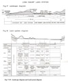 | Long Swamp Land System - Figures 17-18 (PDF - 348KB) To view the information PDF requires the use of a PDF reader. This can be installed for free from the Adobe website (external link). |
Parallel to the long line of Pleistocene aeolianite dunes, which are at or very near the coast, is a long line of poorly-drained country. It forms narrow swamps, marshes, fens, wet heaths and, in the lowest parts, lakes. Termed the Long Swamp land-system, it is one of the smallest of the land-systems in the survey area, occupying only about 8,000 acres, of which about half is Crown land and half is alienated. Nevertheless it is extensive, stretching in a long line from the mouths of the Shaw and Eumeralla Rivers, eastwards to the Surry River, with both the Eumeralla and the Fitzroy Rivers flowing along it for some distance before they break through to the ocean. It starts again at the Bridgewater Lakes west of Portland, extends intermittently to the shallow estuary of the Glenelg River at Nelson, and continues into South Australia as the more extensive Wyrie Association mapped by Blackburn (1959).
For its whole length, it is flanked on the landward side by one of the Pleistocene aeolianite dunes of the Nelson land-system, whilst on its seaward flank, it is bounded either by another such dune or by the sands of the Discovery Bay land-system which frequently overlie a core of dune limestone. In places, the Discovery Bay sands have been blown across the Long Swamp land-system in narrow tongues (see plate 5), forming an intricate pattern of steep sand dunes with corridors of the former Long Swamp. Such areas have been separated as the Bung-Bung land-unit and the rest of the land-system has been mapped as the Long Swamp land-unit.
Sprigg (1952) considers that rises in sea-level to about thirty feet and later to about five feet above the present level occurred in this area during Holocene times, so that the swale now occupied by the Long Swamp may have been flooded by fresh water and possibly by salt water, and shell beds have accumulated in parts. The parent materials of the Long Swamp land-system, therefore, are threefoldcolluvial material from the Pleistocene aeolianite dunes, shell beds of varying age and a mantle of the Discovery Bay calcareous sands, of variable depth and as sheets or dunes.
Soils formed from these materials show some variation, but apart from those on the superimposed dunes, they are all peaty to varying degrees because of their prolonged wetness, and most are calcareous and alkaline. In the wetter parts and near lakes, the soils are more peaty. The following vegetative units are encountered: a fen of reeds (Pharagmites communis) and rushes (Cladium spp) in the wettest parts, a wet heath of paper-bark (Melaleuca squarrosa) and wet scrubs of woolly tea-tree (Leptospermum lanigerum) where it is slightly drier and of Melaleuca pubescens on the edge of the swam. Salt water tea-tree (Melaleuca halmaturorum) has not been encountered but is probably there. The "South Australian Fen" described by Stephens (1943) is in the South Australian continuation of this land-system, and the soils there were identified as friable peats and fine and coarse fibrous peats.
On the superimposed dunes, the soils are mainly the same Discovery Bay loamy sand widespread on the Baudin land-unit and support a dry scrub of coast wattle (Acacia sophorae), muntries (Kunzea spp), she-oak (Casuarina stricta), and pigface (Carpobrotus spp). In moister positions on this Discovery Bay calcareous sand, however, such as on the low dunes and towards the base of the steeper ones, organic matter increases in the surface layers until in the wet corridors and flats, peaty soils are found. The changes in vegetation concomitant with the changes in soil are to dry scrubs of woolly tea-tree on the low dunes, and to a fen of rushes (Cladium spp.) in the swales. Fig. 18 shows the general relationship of these various features.
The erosion hazard on this system is entirely confined to the superimposed dunes of calcareous sand, on which, however, the hazard of wind erosion is extremely high. Any disturbance by grazing or burning on these dunes, or even excessive track-making, can and will lead to widespread sand movement as it has done already on the Discovery Bay land-unit. Elsewhere, however, the hazard is small, although Blackburn (1959) reports wind erosion and loss by burning of the dried-out friable peats of the Wyde Association, following over-drainage and regular cultivation.
There has been successful development of the low-lying soils over much of this land-system in South Australia and in isolated parts of the survey area, by drainage and the use of phosphate, copper, zinc and manganese. Because of the moist soil conditions, perennials like white and strawberry clovers, perennial ryegrass and Phalaris tuberosa can grow on these low-lying soils, which, therefore, are suited to intensive use.
Only two land-units are involved in the land-system apart from the lakes, the Long Swamp land-unit and the Bung-Bung land-unit. The former is composed wholly of the low-lying areas, and the latter has the dunes of calcareous sand superimposed upon low-lying areas.
The characteristics of the land-system may be summarised by saying that it is a series of long, narrow areas of poorly-drained wet and calcareous sands and peats supporting fens and heaths, most of which may be successfully developed after drainage. It is distinct from other swampy land-systems in the survey area, because other swampy areas which are sandy are nearly always acid, such as the Kentbruck Heath land-unit, whereas other swampy areas which are calcareous are heavy-textured, such as the Condah Swamp land-system.
© State of Victoria (Agriculture Victoria) 1996 - .

This work, Victorian Resources Online, is licensed under a Creative Commons Attribution 4.0 licence. You are free to re-use the work under that licence, on the condition that you credit the State of Victoria (Agriculture Victoria) as author, indicate if changes were made and comply with the other licence terms.
The licence does not apply to ‘branding’ or some ‘images or photographs’ that may be owned by third parties. We ask you to seek prior approval to use images using the VRO feedback form. Access to higher quality images can also be provided on request.
This page was last updated on .