
Grampians Land System
Grampians Land System Figure 50 (PDF - 139KB) To view the information PDF requires the use of a PDF reader. This can be installed for free from the Adobe website (external link). |
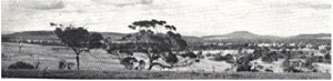 Plate 35 - Mount Dundas, with the Grampians in the background, viewed from the eastern edge of the Brim Brim plateau across the rolling Glenelg land-system | North-east of the survey area lie the Grampians Ranges, rearing abruptly from the plains in a striking series of peaks stretching away to the north. They have a number of westerly outliers of diminishing size, and the most south-westerly of those, the Dundas Range, is in the area covered by this report. It is regarded here as a single land-unit belonging to the Grampians land-system which is much more extensive in the Grampians Ranges themselves and was first identified and mapped there by Sibley as the Grampians Ranges land-system. |
Dundas Range is similar to the main Grampians Ranges in its rock, soil and to a certain extent, vegetation. It lacks, however, the characteristic "cuesta" of the main ranges, that is, the long gentle dip slope parallel to the tilted strata, with a steep escarpment and scree-slope on the other side. The Range rises above the surrounding lateritised tablelands. Steep slopes on the side of the Range become more gentle towards its base which then gradually merges with the tablelands. It is about eight miles long, two miles across at its widest point, and extends in a north-north-westerly direction. The centre is a low saddle between a ridge to the north and a higher peak to the south, the latter about 700 feet above the level of the surrounding plains, and the highest point in the survey area, 1,535 feet. The land-system covers about 5,200 acres in the survey area, half of it Crown land, and half of it alienated.
Upper Devonian to Lower Carboniferous sandstones are the chief rock type and the soils to which they give rise are lithosols and leptopodsols. The former, consisting largely of greyish-brown sandy loams overlying broken or solid sandstone, are found more frequently towards the higher parts and on the steeper slopes of the range, whilst the leptopodsols are on the lesser slopes, nearer the base of the range. The soils support chiefly a short dry sclerophyll forest which, on the rockier or more exposed places is lower and more open, forming a dry scrub, and in the better situations becomes taller to form a dry sclerophyll forest. Stringybark (Eucalyptus baxteri) and some long-leafed box (E. elaeophora) are the chief tree species, with wild cherry (Exocarpus cupressiformis) in places. Red gum (E. camaldulensis) on the surrounding plains extends up the slope somewhat, and intermediate between it and the heath woodland is swamp gum, especially in the wetter places such as soaks. Many of the heath species common in the Grampians are found, particularly Leptospermum juniperinum, L. myrsinoides, Platylobium obtusangulum, Astroloma conostephioides and Xanthorrhoea spp.
No analytical data are available for soils from this range, but similar soils from the Grampians Ranges themselves show low quantities of most plant nutrients. It is possible that improved pasture may be established on the leptopodsols, but annual clovers would probably have to be the basis of them. These soils should also be able to support pines.
The hazard of water erosion on slopes exceeding 7 per cent is severe, despite the possibility of establishing improved pasture on the leptopodsols. On the lithosols, the hazard is more severe.
© State of Victoria (Agriculture Victoria) 1996 - .

This work, Victorian Resources Online, is licensed under a Creative Commons Attribution 4.0 licence. You are free to re-use the work under that licence, on the condition that you credit the State of Victoria (Agriculture Victoria) as author, indicate if changes were made and comply with the other licence terms.
The licence does not apply to ‘branding’ or some ‘images or photographs’ that may be owned by third parties. We ask you to seek prior approval to use images using the VRO feedback form. Access to higher quality images can also be provided on request.
This page was last updated on .