
Girringurrup Land System
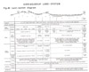 | Girringurrup Land System Figure 40 (PDF - 278KB) To view the information PDF requires the use of a PDF reader. This can be installed for free from the Adobe website (external link). |
"Stony rises" is the term given to fairly recent flows of basalt which, on the local scale, have a rolling, rough and rugged topography and with surfaces, on the rises, which are covered by large boulders of basalt. The difference in height between the hollows and the rises may be up to thirty feet, and the distance between adjacent rises may be anything up to a few hundred yards but are often about fifty to one hundred feet. Some stony rises are very rugged and contorted, with unweathered basalt blocks prominently strewn over the surface; the Eccles land-system is an example. Others have smoother, more gentle topography and the boulders are rounded, partly weathered and less prominent. Stony rises of this latter type associated with Mount Rouse near Penshurst, south-east of Hamilton, have been called the Girringurrup land-system.
They extend from around Penshurst southerly towards Port Fairy, and are bounded on the west for some distance by the Eumeralla River. Their western portion is in the survey area, covering about 21,000 acres in the parishes of Tallangoork and Clonleigh, all alienated, and there, only one land-unit of the same name as the land-system has been recognised.
The land-system has been formed by flows of the Girringurrup basalt, presumably from near Mt. Rouse, covering a basement which towards the cast is Dunkeld basalt and towards the west is bauxitised Hamilton basalt. Between the rises of the Girringurrup basalt, the basement is close to the surface and where it is exposed and can be recognized over a big enough area, has been mapped as the appropriate land-system, but small areas may be exposed within the Girringurrup land-system as mapped. The basement is flat, so that although, locally, the Girringurrup land-system is quite rolling, regionally it is flat and therefore the drainage is internal and the original dissection has been modified only by very local downslope movement of weathered material and by infilling, but not by dissection.
The pattern of components is simple and is based on the catena (Catena is a term introduced by Milne (1936) for a topographic association of soils, and is restricted here to a topographic association of soils on the one parent material and in the same climate.) of soils which is similar to part of a sequence described by Leeper, Nicholls and Wadham (1936) from a survey of basaltic country near Winchelsea. On the rises are reddish chocolate soils (Corangamite stony loam) first named from Winchelsea, with abundant roundered basalt boulders half buried in the soil, and abundant floaters. "Onion weathering" is a feature of the boulders. On the sides of the rises, the soils become darker until in the swales between the rises, they are black, heavy and cracking, sometimes with calcium carbonate ; they fall into the prairie soils or chernozem groups and are very similar to the Mooleric clay of Leeper, Nicholls and Wadham (ibid). In the wetter parts are meadow soils, similar to the Mooleric clay but having gley features also. The catena described above is similar to one commonly found on basalt in moderate rainfall areas, and the soils of the lower topographic positions can be interpreted simply as the infilling of internal drainage basins with the products of decomposition from higher catenary positions.
The vegetation now is a grassland with only an occassional tree here and there, but the original parish plan of Tallangoork compiled in 1862, records for the part occupied by the stony rises the following description: "stony rises and marsh land; fair pasture; wooded with Acacia and Gurn". This probably means that the prairie, chernozem and meadow soils supported a wet tussock grassland, possibly of white tussock or snow-grass (Poa australis) and the stony rises a sparse savannah woodland of manna gum (Eucalyptus viminalis) and blackwood or lightwood (Acacia melanoxylon or Acacia implexa respectively). These relationships are shown diagrammatically in Fig. 40.
Nearer to the presumed source of the rises, around Mount Rouse, the rises themselves are closer together, and the infilled swales occupy a smaller proportion of the whole.
Chemically, the soils are fertile, particularly those in the hollows, which have large reserves of potassium and calcium, and are well supplied with nitrogen and organic matter. The Corangamite stony loam, although it has lower quantities of nutrients in the soil material itself, has abundant surfaces of freshly-weathering basalt upon which the plant roots may feed. The stoniness of the rises, however, prevents cultivation of the Corangamite stony loam, except where much labour has been spent in gathering the surface stones together. Even on these areas the shallowness reduces the water-holding capacity of the soils resulting in lack of moisture during the summer. Moreover, the heavy texture of the periodically cracking soils in the swales restricts the period during which they may be cultivated and makes for severe conditions for surface-rooted species at the end of the summer owing to lack of available moisture.
Previously, Merino sheep thrived on this country and for much of it, fine-wool growing is still the chief land-use. However, parts of the land-system, particularly outside the survey area and to the south where the proportion of flats is greater, have been converted to farms carrying cross-bred sheep for wool growing and fat lamb production. Subterranean clover and ryegrass are the chief species on such parts with white clover as well, where there is dairying.
Sheet erosion occurs on the rises, where slopes are steep but gully erosion and siltation are absent because the slopes are short and there is no drainage system.
The land-unit and land-system may be summarised as smoothly-rounded stony rises with Corangamite stony loams and onion-weathered rounded boulders on the rises, with the swales filled in with clayey material which gives rise to prairie soils, chernozems and meadow soils. Erosion hazard on these soils is slight and in the climate of the area where they have been mapped, they can support cross-bred wool growing with fat lambs and dairying in parts.
© State of Victoria (Agriculture Victoria) 1996 - .

This work, Victorian Resources Online, is licensed under a Creative Commons Attribution 4.0 licence. You are free to re-use the work under that licence, on the condition that you credit the State of Victoria (Agriculture Victoria) as author, indicate if changes were made and comply with the other licence terms.
The licence does not apply to ‘branding’ or some ‘images or photographs’ that may be owned by third parties. We ask you to seek prior approval to use images using the VRO feedback form. Access to higher quality images can also be provided on request.
This page was last updated on .