
Follett and Kanawinka Land System
|
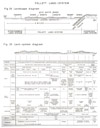
| Follett Land System Figures 25-26 (PDF - 392KB) To view the information PDF requires the use of a PDF reader. This can be installed for free from the Adobe website (external link). |
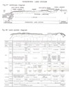
| Kanawinka Land System Figures 27-28 (PDF - 426KB) To view the information PDF requires the use of a PDF reader. This can be installed for free from the Adobe website (external link). |
The words "expanses of poor white sand" or "stringybark scrubs and heathlands" sometimes lead Victorians to visualise an area where profitable farming is impossible, but on this very type of country, in South Australia, fertile farms are being developed. It may not be generally realised that there are considerable areas of similar land in Western Victoria, some under moderately high rainfall. Heaths and stringybark scrubs on white sand are by no means the chief type of country in those parts, nor are they restricted to them, but there is much more of such country near the Victorian-South Australian border than elsewhere in Victoria. It has been mapped there as the Kanawinka land-zone, and comprises the Follett and Kanawinka land-systems.
Nature and Occurrence of Land-systems
Acid white sands with their characteristic vegetation are minor components in a number of land-systems in the survey area, but their main bulk is concentrated in two adjacent and extensive land-systems, the Follett and Kallawinka land-systems. These two form a huge are stretching from near the coast at Kentbruck northerly and then north-north-westerly toward Penola and Naracoorte in South Australia, on both sides of the line of faults separating the coastal plains from the higher platforms to the east. This line of faults is the boundary between the two land-systems. In strict terms the Follett land-system is the area where dunes and sheets of acid white sands predominantly cover the Pleistocene and Holocene deposits of the coastal plain, and the Kanawinka land-system is where similar sand mantles overlie the other physiographic zones, chiefly the Normanby Platform with its surface of Cobbobboonee basalt and the Dundas Tablelands with their surface of laterite. The Kanawinka land-system also includes some areas where the acid white sand covers dissected slopes and such areas, whilst forming a minority of the land-system, are nevertheless often closely interspersed with the relatively flat platform surfaces and their sand veneer.
The chief soils and their associated vegetation are thus the same for both land-systems, being those found on the dunes and sheets of sand. The minor soils and the small exposures of basement differ however in parts, the pattern and degree of drainage are unlike and the erosion hazards may be quite different.
Basis of Subdivision of Land-systems
The two land-systems are broken into sub-systems chiefly on the basis of landscape differences and these are further separated into land-units, six for the Follett land-system and eleven for the Kanawinka land-system, chiefly on the basis of climate. Landscape differences used are the nature of the basement, degree of dissection and the proportion of sand dunes and sand sheets.
In the Follett land-system, the Dorodong, Tooloy and Killara land-units have sand sheets and some dunes predominating with frequent narrow parallel swamps and are grouped as the Tooloy sub-system. Malanganee and Myaring land-units are predominantly of dunes with a few large areas of swamps and thin sand-sheets and together form the Malanganee sub-system whilst Wanwin land-unit is predominantly of sand sheets and forms a sub-system of its own.
In the Kanawinka land-system, the basement of the Kanawinka, Bogalara and Youpayang land-units is lateritised tablelands with only slight dissection whilst the basement of the Weecurra, Mocamboro and Wataepoolan land-units is lateritised tablelands which are dissected to a greater degree. Cobbobboonee basalt underlies Cashmore, Kentbruck Heath, Narrawong and Richmond land-units. Groupings useful from the standpoint of erosion hazard could be made on the above basis but it is more important to consider the depth of the sand mantle because this closely controls the establishment of agriculture or forestry. Sand dunes predominate over Richmond, Narrawong, Mocamboro and Youpayang land-units and these together comprise the Richmond sub-system, whilst the Kentbruck Heath and Cashmore land-units are covered by sheets of sand and form the Kentbruck Heath sub-system. The rest of the land-units, Kanawinka, Roseneath, Bogalara, Weecurra and Wataepoolan together make up the Kanawinka sub-system.
Climatic differences are reflected in the nature and proportion of the different kinds of soils and also rather more sensitively by the vegetation; these differences affect the potential land-use. The following indicates the range and type of variation, resulting from climate, encountered within the land-systems. At the southern end of the Kanawinka land-system, the Kentbruck Heath land-unit, perched on the wettest and windiest part of the survey area, is poorly drained, has highly leached sandy soils with high accumulation of organic matter (acid marsh soils and humus nomopodsols) and carries wet heaths with stunted or mallee stringybarks (Eucalyptus baxteri) and other eucalypts (plate 39). By contrast the Weecurra land-unit further inland with 29 inches to 32 inches rainfall has less severely leached soils (humus and iron-nomopodsols and solodic soils) and supports heaths interspersed with heath woodlands of stringybark, peppermint (E. vitrea) and manna gum (E. viminalis). In the northernmost part of the land-system on the Kanawinka land-unit with 25 inches to 27 inches rainfall, heath woodlands of yellow gum (E. leucoxylon) and pink gum (E. jasciculosa) replace the rnanna gum and peppermint, and the minor soils begin to be of the solonetz rather than the solodic group. There is a similar sequence in the Follett land-system from the Wanwin land-unit in the south with 30 inches to 33 inches average annual rainfall through the Myaring land-unit to the Dorodong land-unit in the north.
Soils
In both land-systems, the acid white sand forms dunes and sheets of thickness varying up to about 40 feet; it thins away to nothing at the edges and sometimes within the area of the land-systems also. On the dunes, and the sheets also, where they are thick enough, the soils are typically nomopodsols; iron-nomopodsols (Kowree and Ross series) are in the drier positions, and humus-nomopodsols (Richmond series) in the wetter. In the north, as in the Dorodong land-unit, the iron-nomopodsols occupy most positions on the dunes including the swales, and the humus-nomopodsols are found only at the base of some dunes and on the sand sheets. Further south, the humus-nomopodsols occupy more of the locally drier sites because of the higher rainfall and the ironnomopodsols are progressively restricted until in the extreme situation at Kentbruck Heath, they are represented by the Ross sand found only on the summits and sides of the steepest dunes, the humus-nomopodsols occupying all the lower dunes and swales. In the wettest parts of Kentbruck Heath, namely, at the foot of the dunes and on the sand sheets, the accumulation of organic matter in both A and B horizons of the humus-nomopodsols is great enough for acid marsh soils and even peats to be formed.
Less common soils are those on restricted areas where the acid white sands are very thin or absent, exposing the basement. In the Follett land-system, the basement is mainly of clayey lagoon deposits and some dune limestone, so that these less common soils are similar to those dominant in the Strathdownie land-system, namely, solodic soils of the Follett family, meadow soils, peats and very occasionally terra rossas. Kanawinka land-system by contrast has a basement of Tertiary laterite which caps varied pre-Tertiary materials, or of basalt with surface alteration, or of the materials exposed by a dissection of these surfaces. In this land-system therefore, the less common soils are more varied than for the Follett land-system and include solodic soils of both the Follett and other families, medium-textured leptopodsols and meadow soils. In places, such soils are those with clay at shallow depth and are dominant over more than about 500 acres, which is large enough to warrant mapping at the published scale of survey. There they have been mapped as sub-units (e.g. Tooloy, and Kanawinka,), because they are more suitable for rapid agricultural development than are surrounding areas of the dominant soils. Land units of both land-systems near the coast, namely, Cashmore, Kentbruck Heath and Wanwin, sometimes have the slightly-acid orange sands typical of the Nelson land-system.
In general, dominant soils of both Follett and Kanawinka land-sytems are nomopodsols of both Won and humus sub-groups with acid marsh soils in the areas of highest rainfall. Soils less common are mainly solodic soils and slightly acid sands in particular parts of the landscape.
The characteristic feature of the, nomopodsols is their severely-leached nature, which arises from the combination of a coarse fabric and low base content of the parent material. Analyses of the group show this feature and the commentary points out the strong acidity, low content of exchangeable calcium and other basic cations, the high degree of base unsaturation, low content of phosphorus and potassium and usually of nitrogen also. Trace elements copper and zinc are in low quantity. Nomopodsols formed on acid white sand are also coarsely textured and therefore very freely drained, except where an impeding layer of coffee-rock has been formed. In areas of adequate rainfall, free drainage is a desirable feature, but where rainfall is low, such a feature has disadvantages for shallow-rooted plants, as it results in low reserves of available water. For both land-systems, then, the dominant soils have very poor nutrient status and are very freely drained, excessively so in drier parts, except where hard coffee-rock has formed.
Vegetation
The native vegetation of the two land-systems is, as a whole, distinctive from that of other land-systems. Within the land-systems, factors causing variation are the wetness of the site and the nutrient status of the soil within the depth of rooting. These factors themselves vary according to the climate and the depth and coarseness of sand covering a heavier substratum.
In both land-systems, the general pattern of vegetation with topography and soils is based upon a fundamental sequence of five land-components from the top of a sand dune to the lowest part of the adjacent sand sheet.
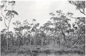
Component one is on the deeper coarse sands of the dunes such as Kowree series and is a scrubby dry sclerophyll forest of stringybark with heath and bracken understorey.
Component two is on the deeper coarse sands with impeding coffee-rock horizon at moderate depth such as Richmond series of the sand dunes or sand sheets. It is a moderately close heath woodland of stringybark with a heath understorey which does not include bracken.
Further down the sequence is the third component, comprising heath woodlands of eucalypts with heath understorey not including bracken. It is on soils with coarse sand overlying an impeding horizon of clay at shallow to moderate depth, such as the Follett family. Where the site of component three is sloping or slightly dissected, that is, relatively dry, the eucalypts are in moderately close heath woodland formation and are predominantly stringybark with a few gums. With increasing wetness of site, however, as on the flat areas with shallow sand sheets, conditions become more severe, first for stringybark and then for gums, so that on the lower parts of component three, there are only gums scattered amongst the heath.
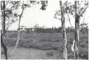
In the lower sites, conditions are too wet for these gums and component four consists of short wet heaths with no trees at all. Where, in components three or four, the sand of the surface horizon is of finer texture, savannah woodlands of gums are found. There, a similar sequence of topography or wetness gives a sequence from gums such as pink, yellow or manna gum in the drier sites to red gum or swamp gum in the lower.
In the lowest part of the landscape are swamps, which make the fifth component. They usually carry reeds and rushes, although tall wet heaths can also occur in very wet sites if there is deep sand. The sequence of components described here is shown in Figs. 26 and 28 and Plates 11 to 15.
The climatic variation within the land-system modifies this general picture in three ways. The first is that as the climate becomes wetter, the vegetative units characteristic of situations of a particular degree of wetness or dryness are progressively more restricted to the drier topographic sites, so that in the land-units with the highest rainfall, wet heaths predominate over most areas except steep dunes. Secondly, climate may control which of the eucalypt species other that stringybark are present in the heath woodlands and savannah woodlands of component three, and at which position they occur in the topographic and soil sequence. Finally climate exerts an indirect effect on the vegetation through the soil. The more intense leaching to which sandy soils are subjected in a wetter climate produces more severe soil conditions such as low pH values and base-unsaturation, which, together with poor drainage conditions, restrict the few eucalypts which can grow on the land-systems to dwarf or specialised forms like mallees.
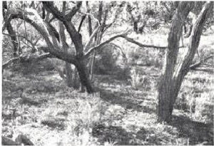
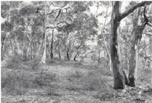
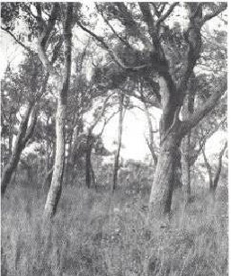 Plate 12 - Where the sand is not quite so deep as in places like that shown in Plate 11, the stringybarks have a heath understorey which is more dense and does not contain bracken. | 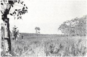 Plate13 - In wetter sites, the stringybark cannot grow. Its place may be taken by manna, swamp,yellow or pink gums (plate 14), especially if there is clay at shallow depth; alternatively, these gumsmay not grow because of the infertility of the surface sand, and treeless heaths result as shown here. |
Plate 14 - Heath woodlands of manna, swamp, yellow or pink gums are found where the soil is seasonally wet because of an impeding horizon of clay at shallow depth. (This type of land is well suited for development, if extensive.) |
Plate 15 - Swamps, permanent or seasonal, occupy the lowest sites in the Follett and Kanawinka land-systems. Where the sand-mantle is thin, these are surrounded by flats of red gum. (This is a view from a red gum copse across a heath to areas of stringybark on deeper sand.) |
Thus, as well as the fundamental pattern described above, in which scrubby forests or heath woodlands of stringybark predominate, the various land-units show the eucalypts indicated in Table 9 in the heath woodlands, savannah woodlands and mallee wet heaths.
All of those eucalypts are in addition to the predominant stringybark. In the wettest land-units, Wanwin, Cashmore and Kentbruck Heath, scrubby forests and savannah woodlands virtually disappear from the landscape and most eucalypts are or the mallee form, so that wet heath and dense mallee wet heaths occupy most of these land-units.
In the Kanawinka land-system, but not in the Follett land-system, there are also dissected areas with moderate slopes. Deep sands on these slopes carry component one, namely, dry sclerophyll forests or stringybark with bracken understorey. Shallower sands overlying clay or ironstone support dry sclerophyll forests or heath woodlands of stringybark with a sprinkling of the other eucalypts appropriate to the land-unit or topographic position, as described earlier for such soils.
Table 9 - The Eucalypts which are present in different vegetative formations in the various land-units of the Follett and Kanawinka land-systems.
| Land-Units | Rainfall Belt (in.) | Eucalypts (other than Stringybark) which are Present in - | ||
| Mallee-Wet-Heaths | Heath Woodlands | Savannah Woodlands | ||
| Dorodong, Kanawinka, Bogalara | 25-27 | .. | Pink gum, yellow gum | Red gum |
| Killara, Tooloy, Roseneath, Youpayang | 26-29 | .. | Yellow gum, manna gum, peppermint, swamp gum | Red gum |
| Myaring, Malanganee, Mocamboro, Weecurra | 28-32 | .. | Manna gum, peppermint, swamp gum | Red gum, swamp gum |
| Wataepoolan, Narrawong | 32-33 | .. | Manna gum, peppermint, swamp gum, messmate | |
| Wanwin | 30-33 | Manna gum, peppermint | Manna gum, peppermint, swamp gum, snow gum | |
| Cashmore, Kentbruck Heath | 32-36 | Manna gum, peppermint, bog gum, swamp gum | ||
 |  |
| Plates 16 & 17 - On gentle slopes of the Kanawinka land-system where the sand mantle is thin, the heath understorey is sparse and contains species like ground yacca and duck bush. (Where the surface is infertile and the underlying material is ironstone the dominant eucalypt is stringybark (plate 16); where the surface sand and underlying clay are more fertile, scrubby tall woodlands of yellow gum, pink gum, manna gum or swamp gum are found.) | |
Land-use
(1) Previous land-use. - Until recently, both land-systems were either unused or used only for rough grazing with a little timber cutting. The exceptions were the savannah woodland flats which have been used for Merino wool growing and some of the soils of the Cashmore land-unit which have been used for growing potatoes.
Soils of the savannah woodland flats are usually solodic soils with fine sandy A horizons. They are similar to the dominant soils of the Strathdownie and Dundas or Glenelg land-systems. Their agricultural development is similar, namely, the establishment of pastures of annual or perennial clovers and perennial grasses with the use of superphosphate, and the growing of fodder crops and possibly cash crops. Remarks made in the section on land-use for those other land-systems apply to this minority of soils. Such woodlands are not extensive and form significant proportions of the landscape only in the Kanawinka, Tooloy and Roseneath landunits where they have been mapped as sub-units.
There was no intensive land-use, however, on the soils which are dominant over the greater part of these two land-systems until recently. The areas of deep white sands were settled quite early but later were abandoned because of infertility and reverted to the Crown. Even now, the low agricultural and grazing value of the acid white sands, when not improved, is shown by the high proportion 44 per cent and 54 per cent of unoccupied land in the Follett and Kanawinka land-systems, respectively. In both land-systems, the proportion exceeds that for any other land-system of substantial area, except Cobbobboonee, which is predominantly Reserved forest land. By contrast, the Strathdownie and Dundas or Glenelg land-systems, which are the respective counterparts, without the sand mantle, of Follett and Kanawinka are almost entirely occupied.
(ii) Potential land-use. - The growth of plants depends upon a sufficiently long growing season and an adequate supply of nutrients. In an area over which the seasonal light and temperature regimes are similar, the length of the growing period in different parts is largely a matter of the supply of sufficient water and air to the root zone of the plants. The ability of the dominant soils of these two land-systems to supply, on the one hand, nutrients and, on the other hand, water and air to the root zone will now be examined for pasture species, both shallow rooted and deep rooted and also for pines.
(iii) Pasture potential. - Pasture species vary in their requirements for nutrients and some better than others can survive on poor soils. The nomopodsols however are so poor in nutrients that only species which are adapted to low nutrient status can survive. Examples are stringybark, yacca and some heaths of the native flora and only very few introduced grasses, notably Yorkshire fog.
Plots at various sites in these two land-systems have demonstrated the fertiliser requirements for establishing pasture species on most of the dominant soils (Margetts, Newman 1960). In general, phosphate is essential for all species, copper for legumes and frequently zinc for most legumes. On soils with surface horizons of low pH especially the acid marsh soils, lime is necessary for successful nodulation and establishment of clover and can be applied mixed with superphosphate, banded or broadcast according to the degree of acidity. Lucerne requires lime for its establishment on virtually all the dominant soils of these land-systems. In some instances, therefore, legumes will not grow without copper, zinc and lime as well as phosphate, and the key to pasture establishment as far as fertilisers are concerned is to know the correct combination. The importance of understanding the limitations of the soil is shown at Kentbruck Heath where white clover will not grow unless both copper and lime be supplied.
Total nitrogen is usually low except in some of the marsh soils on which native heaths include legumes as at Kentbruck Heath. Nearly always, the C/N ratio is high so that adequate supplies of nitrogen for grass species must be met from introduced legumes, the successful establishment of which therefore becomes of great importance. The content of both total and available potassium in the soils derived from acid white sand is invariably very low except in the immediate surface horizons where, doubtless, it has accumulated from the heath litter or from the ash following bush fires. Quantities elsewhere in the coarse sandy horizons of the soil are so low, however, that once the reserves of the surface horizon have been removed by the sale of agricultural products off the farm, (hay in particular making heavy drains,) then recurring applications of potassium will almost certainly be necessary to preserve a suitable supply for plant growth. However, clayey horizons of soils in these land-systems nearly always have moderate levels of potassium, probably sufficient for the needs of the plant, so that where such a horizon is within the depth of rooting of whatever plant is growing, the need for potash will be diminished and possibly eliminated. The presence of a clayey horizon within the depth of rooting may well be the major economic factor influencing the development of these land-systems in those parts where, for reasons of water supply, the pasture potential is not high and the returns are therefore less.
With adequate supplies of nutrients-phosphorus, potassium, trace elements and lime, improved pastures can be developed. Annual improved pastures based on subterranean clover, ryegrass and phalaris allow cross-bred wool growing; perennial improved pastures based on white clover, late varieties of subterranean clover, strawberry clover and red clover, perennial ryegrass and phalaris can support crossbred wool growing with fat lambs, beef cattle, dairying or a combination of these.
The development of these pastures then depends upon the availability of water to the root zone of the pasture species. Since those species are mainly shallow-rooted, this varies inversely with the depth of sand above an impeding horizon if any, and directly with the rainfall and lower topographic position.
In the lower rainfall areas of the land-systems, such as the Dorodong, Tooloy, Bogalara, Youpayang, Kanawinka and Roseneath land-units (25-21 inch rainfall belt), the soils of component one, namely, the deep coarse sands chiefly Kowree series are excessively freely drained. They do not have the water-holding capacity within the depth of rooting of shallow-rooted species sufficient to meet the needs of shallow-rooted perennials in the dry season. For the same reason, the period of active growth and production of shallow-rooted annuals is probably too restricted to warrant the cost of developing and maintaining the annual pastures. Deep-rooted species, annuals or perennials, can survive and produce for a longer period into the summer because they have access to the water available in a larger volume of soil . Whilst there are suitable deep-rooted grasses, legumes however are the prerequisite on account of the low nitrogen status of the soils and the basis of pasture development is the establishment of a legume. There is no suitable deep-rooted annual legume and the chief deep-rooted perennial pasture legume is lucerne which however, is difficult to establish on moderately-acid soils. Even on the less-acid soils which are sometimes found in the land-system, establishment will require the same careful attention to detail as is necessary for the sandy soils of the Bangharn Scrub in South Australia (Tiver 1958), but on the more-acid sands, such as the deeper phases of Kowree sand and the Richmond sand, which are commoner, its establishment and maintenance will probably be difficult and uncertain. It is unlikely therefore that good pastures can be established and maintained economically over areas in this rainfall, which are substantially of the deep and acid coarse sands that is, component 1. Where this component occurs as a small proportion amongst a majority of components capable of economic development, the economic burden of development can be distributed satisfactorily over the wider area. However, where this component forms the majority of the landscape, as over most of Youpayang and some parts of Dorodong, Tooloy, Bogalara, Kanawinka and Roseneath land-units it would be better left alone.
In the soils of component two and particularly in the soils of component three, the restricted drainage creates a perched water table. These soils are the moderately deep coarse sands above an impeding horizon, such as Richmond series and the shallow coarse sands above an impeding horizon, namely, soils of the Follett family. This restricted drainage has the same effect as an increase in the available water or the water holding capacity within the root zone. As shown in Figs. 7 and 8, an increased water holding capacity within the root zone in this rainfall will allow an annual to grow and produce much longer than it would otherwise, and a perennial to survive. On this basis, for the same land units as just discussed above, the soils of component two, chiefly Richmond series, can probably support annual pastures based on mid-season or early varieties of sub-clover economically. The soils of component three have a moisture status satisfactory for late annual pasture and possibly perennial pastures in suitable topographic situations, based on late-season varieties of subterranean clover, strawberry clover and even white clover, with perennial ryegrass and phalaris.
Along the same lines, in areas of somewhat higher rainfall, (27-30 inches), including the Killara, Malanganee, Mocamboro and Weecurra land-units, deep coarse sands of component one may support annual pastures satisfactorily. The soils of component two, moderately deep sands such as the Richmond series, and those of components three and four, the shallower sands, will support late annual and perennial pastures, based on late-season varieties of subterranean clover and on white clover.
In the highest rainfall zone of the two land-systems (with rainfalls above 30 inches), as the Myaring, Wataepoolan, Narrawong, Richmond, Wanin, Cashmore and Kentbruck Heath land-units, the deep, coarse sands of component one, the Ross series are probably suitable for pastures based on late-season shallow-rooted legumes with deep-rooted perennial grasses. Moderately deep sands such as Richmond series or sands in the lower topographic positions such as marsh soils can carry perennial pastures based on white and red clovers, perennial ryegrass and cocksfoot. The lowest sites, however, of whatever depth sand, may be too wet for development of any sort without drainage.
Swamps in any part of the land system, when drained, will grow annual spring and summer fodder crops, particularly if the drainage can be controlled during the different seasons.
A brief summary of the pasture potential on the chief components of the two land-systems follows. Component one, the deep coarse sands, Kowree and Richmond series, should be avoided for pasture improvement where it occupies large areas in the lower rainfall zone (Dorodong, Tooloy, Bogalara, Youpayang, Kanawinka and Roseneath land-units). Similar soils in the middle rainfall zone (Killara, Malanganee, Mocamboro and Weecurra land-units) are probably not suitable for development. On this basis, the whole of the Richmond sub-system in these rainfall zones namely Youpayang and Mocamboro should be avoided. Most other parts of the land-units mentioned above - except moderately deep sands on dissected slopes in the Kanawinka land-system - are suitable for development to cross-bred wool growing either alone or with fat lambs, and some settlement schemes have already been established, mainly in Kanawinka and Tooloy land-units. It should be remembered however that where the soils on which pasture is being developed are those with no clayey horizon within the rooting zone of the species used, then the economic burdens of fertiliser requirement will be severe in relation to the likely level of production. In the higher rainfall zone (Myaring, Richmond, Narrawong and Wataepoolan land-units) the deep coarse sands such as Kowree and Ross series may be suitable for annual pastures but fertiliser and development costs could be excessive. In the Wanwin and Kentbruck Heath sub-systems, however, namely Wanwin, Cashmore and Kentbruck Heath land-units, most of the area can carry perennial pastures to support cross-bred wool growing with fat lambs, beef cattle or dairying. Drainage will be needed in parts of these sub-systems particularly Kentbruck Heath land-unit, and cash-cropping is probably desirable to offset development costs.
(iv) Pine growing potential. - Pines have been proposed for these two landsystems and some lantations of Pinus radiata and trial plots of P. pinaster established in the Myaring and Malanganee land-units. Recent information on the nutrient requirement of these species in Southern Australia is in papers by Hatch (1961), Hopkins (1960), Hall (1961) and Waring (1962), whilst Poutsma and Simpfendorfer (1962) and Gibbons, Si bley and Rowe (1957) have discussed the drainage requirements of P. radiata. Also, an examination has been made of plantations of P. radiata and their environment in both south-western Victoria and nearby parts of South Australia, on soils common in the Follett and Kanawinka land-systems. The conclusions from these various sets of evidence are now considered.
The first group of papers show the invariable need for phosphorus applications on the poor sands, point out the increase in growth, sometimes considerable, from nitrogen applied in the early stages and show that copper and zinc may be deficient particularly in wet sites. Waring (1962) and Hatch (1961) have also demonstrated the considerable depletion of soil nitrogen from an already low quantity by one crop of P. radiata on a range of poor soils including deep coarse sands similar to the Richmond series, and stress the need to replenish the organic matter and nitrogen status if any further production is to be obtained. Hopkins' (1960) assessment of the economics of production, on sands in Western Australia similar to the Kowree series was that P. radiata was not suitable but that P. pinaster probably was, owing to its lower nutrient requirements, despite the much longer period, sixty years, needed to obtain a crop. However, the more severe seasonal moisture-deficit in Western Australia may mean that such a view would be too harsh an assessment of the position in the Kanawinka and Follett land-systems. Hall (1961) considers that growing P. radiata is a marginal enterprise on similar sands at Longford in eastern Victoria with a well distributed 28-inch average annual rainfall and emphasises the need to cut production costs; however, he also points out that there are substantial fertiliser costs which cannot be reduced.
The poor growth without fertilisers on deep leached sands like the Kowree series of component one may be caused partly by dryness of the soil within the root zone during summer. This is because, although pine roots can grow deeply in loose soil, the poor nutrient status of these particular soils may so severely restrict such growth that the root zone is not great enough to tap an adequate reserve of soil moisture during the period of water stress. If this be so, then both the poor nutrient status and the excessively free drainage status of the soils are together responsible for the unsatisfactory growth of pines on these soils. By contrast, the orange sands or sandy leptopodsols of the adjacent Nelson land-system are suited to P. radiata, because they have a somewhat better nutrient status and their moisture holding capacity is greater because of their slightly heavier textures at depth. In the higher rainfall parts of the land-systems, soils similar to the Kowree series are the Ross series and they may be able to give better growth with lower fertiliser applications because the summer moisture stress is not so severe.
Poutsma and Simpfendorfer (1962) found that soils with a perched water table caused failure of P. radiata in southern Victoria through poor subsurface drainage, a conclusion borne out by the observations of Gibbons, Sibley and Rowe (1957) who correlated poor pine growth at Longford with the closeness to the soil surface of an impeding horizon. The latter investigators thought that, in a 28-inch rainfall in eastern Victoria on a rolling topography, soils with an impeding horizon less than about 12 inches deep were unsuitable for P. radiata.
The evidence from the plantations of P. radiata in south-western Victoria and nearby parts of South Australia (Chapter 33 and Appendix III) indicates that, with the distribution of rainfall and temperatures which is experienced there, the best sites are likely to be found in areas of high rainfalls on well drained, slightly acidic and strongly-coloured sandy soils with clay at between about 24 inches and 48 inches. Sandy soils which are deeper, coarser and light grey cannot be expected to grow good plantations of pines.
Therefore on the one hand, the soils of component one, the Kowree and Richmond series, in the drier parts of the land-system, may not be suitable for P. radiata owing to poverty and low moisture-holding capacity, whilst on the other hand, most soils of the Follett series or any other soil with an impeding horizon near to the surface, are too poorly drained for P. radiata over all except the driest part of the land-system. The most suitable soils of the dominant sequence are probably those with an impeding horizon between about 24 and 48 inches from the surface, such as the shallow phases of the Richmond series and the deep phases of the Follett series and particularly the soils of component three. Such soils are continuously extensive only in the Myaring, Malanganee, Killara and Weecurra land-units and most of the existing plantations are there. In the wetter zone, the severity of seasonal fluctuation is less and the range of suitable soils may he widened to include deep coarse sands like the Ross series which are particularly widespread in the Richmond and Myaring land-units. In a few parts, sandy soils with richer colours or carrying better timber are common, particularly in the areas mapped as Tooloy, sub-unit, and these parts will probably grow plantations of Site Quality Rating VI or V (see Table 17).
A brief summary of the likely pine growing potential of the two land systems follows. The deeper impoverished coarse sands of component one such as the Kowree and Richmond series especially in the drier land-units holds very little promise for the satisfactory growth of P. radiata although P. pinaster may grow, whilst the soils with an impeding horizon less then 18 inches from the surface are too poorly drained. Only those soils with an impeding horizon at between 2 and 4 feet from the surface, chiefly on component three are likely to be satisfactory and soils with richer-coloured A2 horizons. Continuous large areas of these are few. The deeper coarse sands such as the Ross series in the better watered areas may be suitable. It would be most unwise to attempt large-scale plantations of any pine species in these two land-systems until favourable indications are much more plentiful than they are at present.
Soil Erosion
There is little soil erosion in the land-systems at present but some parts have low or moderate erosion hazards. A low to moderate wind-erosion hazard exists on the deeper sands after clearing and cultivation but is then rapidly reduced by the tendency of bracken to recolonise the surface. Strong winds on the dunes on the western escarpment of Kentbruck Heath land-unit create a hazard and have been responsible for some movement of sand following bush fires and the development of tracks. Elsewhere, bush fires do not seem to have caused wind erosion of the coarse sand and thin crusts have often been observed on the acid white sands. There is a moderate water erosion hazard on the few sloping areas of sonic land-units of the Kanawinka land-system, particularly Youpayang, Mocamboro, Weecurra and a slight hazard in Kanawinka.
Summary
The characteristic features of the two land-systems are their veneer of leached acid white sands as sheets and dunes, and the resulting impoverished sandy nomopodsols which carry a vegetation mainly of stringybark or heaths sometimes with scattered gums. Differences between the land-systems arise from the nature of the basement beneath the sand mantle, the one land-system being coastal plains and the other, tablelands which are sometimes dissected. Both land-systems show parallel variations with climate, made evident mainly by the native vegetation and potential land-use, and this, together with landscape variations is the basis of further subdivision into land-units.
At present these land-systems are largely unused and much of them, particularly those components with deeper coarse sand, is at present economically unsuitable for agriculture or pines. Nevertheless, by the use of trace-elements, many areas can be developed satisfactorily to pastures according to the moisture status of the soils. The rationale of this in relation to climate, soils and topography has been given in this chapter. In some places the need to continually provide fertilisers may be a burden, and warrants care in selection of the land. Pines may grow satisfactorily on some land components but on most there is a considerable doubt which should be resolved before large scale plantings are made.
© State of Victoria (Agriculture Victoria) 1996 - .

This work, Victorian Resources Online, is licensed under a Creative Commons Attribution 4.0 licence. You are free to re-use the work under that licence, on the condition that you credit the State of Victoria (Agriculture Victoria) as author, indicate if changes were made and comply with the other licence terms.
The licence does not apply to ‘branding’ or some ‘images or photographs’ that may be owned by third parties. We ask you to seek prior approval to use images using the VRO feedback form. Access to higher quality images can also be provided on request.
This page was last updated on .