
Cobbobboonee Land System
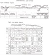 | Cobbobboonee Land System Figures 44-45 (PDF - 530KB) To view the information PDF requires the use of a PDF reader. This can be installed for free from the Adobe website (external link). |
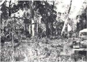 Plate 32 - A forest of messmate an narrow-leafed peppermint is characteristic of the Cobbobboonee land-system. It is a valuable source of hardwood timber | The timber resources of south-western Victoria are limited. One hundred and twenty years ago, mature woodlands of almost pure red gum (Eucalyptus camaldulensis) stretched over big tracts of land, but such country was easy to develop into land ideal for Merino wool growing, and in the process virtually all of it has been alienated and most of the trees destroyed. Stringybark (E. baxteri), an excellent timber, grows extensively, but unfortunately chiefly on soils of low fertility, the nomopodsols, which produce a scrubby tree suitable only for posts and firewood.
Messmate (E. obliqua) is the only other native species of milling quality in western Victoria. It requires moderate soil fertility, good soil drainage and high rainfall, and in the survey area this combination is found chiefly on the Cobbobboonee basalt to the greater part of which therefore the chief stands of native hardwood and the only substantial source of milling timber are restricted. Characteristic patterns of soil and vegetation are found on the Cobbobboonee basalt and the Cobbobboonee land-system is defined as the land which is predominantly covered by Cobbobboonee basalt and which receives average annual rainfalls exceeding 30 inches. Most of it is characterised also by dry sclerophyll forests in which messmate is a major species. |
All the land-system receives more than 30 inches average annual rainfall and most of it more than 33 inches whilst in some western parts the rainfall exceeds 35 inches. These latter parts, together with limited areas of adjacent country, probably comprise the only part of the survey area where rains sufficient for the growth of deep-rooted summer annuals can be expected. An assessment of the effect of the climate at Portland, which is in the land-system, on the growth-rate and production of some species, is shown in Fig. 9. Over most of the land-system the climate would be at least as favourable as at Portland and for the western parts, more so.
Parent Materials
Cobbobboonee basalt has been extruded over the west and north-west of the surface of the Normanby Platform forming a wide and stretching north-north-west from Portland towards Dartmoor. North of Heywood, the basalt covers the junction of part of the southern boundary of the Dundas Tablelands with the Normanby Platform. It caps Mount Clay and a small patch is exposed on Cape Bridgewater. Round swamps are occasionally found on the basalt but in two localities, around the township of Gorae and about nine miles north-west of Heywood, they are numerous and close together.
Ortstein, a nodular ironstone, is common on the surface of the basalt, particularly in the upper parts of the landscape. This ortstein (plate 33) is rarely more than two feet thick, is pisolitic and sometimes the pisolites are cemented together to form a hard mass. In some places the ortstein is exposed at the surface in a massive form, but this is not common and the ortstein is more often found as a zone of loosely cemented and decomposing pisolitic ironstone gravel in the soil. Unweathered basalt may directly underlie the ortstein, but usually between the two is a zone of mottled clay merging into decomposing basalt. Even where there is no ortstein, there is often a distinctly and finely-mottled red clay with weak ironstone concretions. The ortstein is probably residual from a previous age when it formed a capping over at least part of the basalt. Neither the coarsely-mottled zone and pallid zone typical of classical laterite nor the deep kaolinitic weathering characteristic of the Hamilton basalt flow has been encountered beneath the ortstein. Dissection is generally slight and exposes fresh basalt. The inference from the lack of deep weathering and deep dissection is that the Cobbobboonee basalt was extruded after the period of lateritisation and also later than Hamilton basalt, whilst the presence of the ortstein and its position in the landscape suggests (Hallsworth and Costin 1953) an early or mid-Pleistocene age.
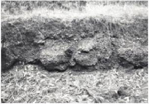 Plate 33 - The basalt of the Cobbobboonee land-system has been weathered (probably during the early or middle Pleistocence, to give an ironstone formation known as orstein. This ironstone is the parent material for some of the soils of the land-system, and is shown here in the parish of Balrook.) | Beneath the basalt are the basement rocks of the Normanby Platform. These are chiefly Miocene limestone but north of Heywood there is a greater range of Tertiary rocks including sandy sediments and early Tertiary deposits. Dissection through this country therefore exposes, progressively, a thin capping of ortstein, basalt and finally Tertiary sediments, chiefly Miocene limestone. Basis of Subdivision Subdivision is according to the materials exposed and the presence of swamps. Since the Normanby Platform slopes gently down to the east, most of it is drained by easterly-flowing streams with headwaters well to the west. Dissection by these streams is mild and has not penetrated beyond the basalt into the Miocene beds except on the east or in the main stream lines. Areas where they have done so are similar to the shallowly-dissected parts of the Greenwald land-system and parts of the Heywood land-system; such areas have been mapped separately only where they form the greater part of the landscape as in the Springbourne land-unit. By contrast, on the western escarpment of the Normanby Platform, streams dissecting the basalt are short and deeply entrenched and the dissected areas, where extensive enough, have been mapped as the Crawford sub-system of the Greenwald land-system. North of Heywood the basalt generally slopes south from the Dundas Tablelands to the Normanby Platform, but on the northern perimeter of the basalt the slopes are towards the Crawford valley. Chief streams therefore flow south and because of the grade moderately dissect the landscape to expose a range of Tertiary sediments. |
Three sub-divisions of the Cobbobboonee land-system are recognized on the above basis. Cobbobboonee sub-system is generally slightly dissected and has frequent remnants of ortstein. Gorae sub-system is characterised by swamps and the Portland sub-system has more prominent slopes and few ortstein remnants. Further discussion is on this basis.
Cobbobboonee Sub-System
Three land-units compose the Cobbobboonee sub-system, namely, Cobbobboonee, Annya and Mount Clay.
Cobbobboonee land-unit is the largest (115,000 acres) and is that part of the sub-system which is on the Normanby Platform proper. Belonging to the sub-system which is only slightly mildly dissected, the Cobbobboonee land-unit occupies the elevated perimeter of the tilted plateau on the west and southwest, stretching eastward and north-eastward until it encounters the more deeply-dissected Portland sub-system.
Cinder and lava cones such as Mount Kincaid occasionally stand up above the basalt flow. In a few scattered areas, low dunes and thin sheets of acid white sands cover the soils on basalt, and small amounts of such sand may have influenced the top soils over most of the land-unit.
The characteristic and widespread feature of the land-unit however is the presence of ortstein or of strongly mottled red clay with weak concretions, in the upper parts of the slightly-dissected landscape.
There, the Gorae and Cobbobboonee series of soils are common and frequently associated with ortstein and mottled clay respectively. They are medium-textured leptopodsols, the former with much gravel in the A horizon and in the top of the B horizon whilst the latter has less gravel and is redder or browner. Gorae series is the better drained because of the gravel, despite the redder hues of the Cobbobboonee series. Included in the Gorae series are profiles each with a thin veneer, less than 4 inches, of acid white sand, presumably wind-deposited and usually mixed with the surface horizon to form a greyish-brown gravelly sandy loam. Lower in the landscape are small areas of soils developing on freshly-weathering basalt away from the influence of the ortstein and mottled clay. Soils there are transitional krasnozems (see p. 281) named the Sherburn series. Fertility of these soils - the chemical status is moderately good except for a low phosphorus content, and the water-holding capacity is high.
On these three series, the vegetation is closely related to the drainage and fertility status of the soil under the high rainfall of the land-unit, 32-35 inches. Apart from blackwood (Acacia melanoxylon) and wild cherry (Exocarpus cupressiformis) which are scattered over the whole land-system, there are five tree species, all eucalypts, in the land-unit and land-system. These are stringybark (E. baxteri), messmate (E. obliqua), peppermint (E. vitrea), manna gum (E. viminalis) and swamp gum (E. ovata) and their increasing tolerance of poor drainage is in the order in which they are named. Only the first two species, stringybark and messmate are likely to produce good milling timber.
On the Gorae series, the first four of these species form a good tall dry sclerophyll forest with a sparse dry heath understorey including bracken; originally, messmate was probably dominant but much of both the Messmate and stringybark has been cut out for milling. Cobbobboonee series carries similar vegetation except that the first species, stringybark, does not grow because the series has a slightly more impeded internal drainage. The transition from the Cobbobboonee series to the Sherburn series in lower and wetter positions of the landscape is marked by the elimination of the second of the five species, messmate, owing to wetter conditions. This leaves only peppermint and manna gum in the association, the former dominant. In the Sherburn series, conditions are moist enough for manna gum to be dominant and also for the fifth species, swamp gum, to grow also; the heath understorey is thicker and contains wet heath species. In the lowest positions of the landscape (in the swamps or on the meadow and prairie soils developed from alluvium which covers the Miocene basement) only swamp gum and sometimes peppermint are found, together with a dense wet heath understorey, and form a swamp sclerophyll forest. This is a common component in the Heywood land-system. In the few places where dissection is deep enough to expose slopes, but not flats, of Miocene limestone, the vegetation is a dry sclerophyll forest dominated by peppermint; such a component is characteristic of the Greenwald land-system.
Veneers of acid white sands odify this picture of the vegetation. Wherey they are thin, the chief effect is to induce a denser heath undersorey but where they are thick they give rise to nompodsols. As in the Kanawinka and Follett land-systems, these nomopodsols support a scrubby dry sclerophyll forest of stringybark, heath woodland of stringybark, or wet heath, with increasing wetness of site respectively.
On the occasional cinder and lava cones, chocolate soils which cover the summit and upper slopes carry a tall woodland of manna gum; on the lower slopes are black cracking clays, namely prairie soils, which carry a forest or tall woodland of swamp gum.
These relationships of geomorphology, soils and vegetation are shown in the land-system diagram (Fig. 45) and the resulting components serve as a basis for considering land-use.
The high rainfall of the land-unit, 32-35 inches, and the moderate fertility and reasonable drainage status of most of the soils have allowed good timber to grow, especially on the components characterised by the Gorae and Cobbobboonee series. Originally, practically all the land-unit was used for hardwood production, mainly messmate and some stringybark, and most of it still remains as State forest. It is the biggest single area, 37 per cent of the Reserved forests, in the survey area.
For the same reasons of soil and climate, however, perennial pastures, some crops, fruit trees and exotic timber can grow forming the basis for intensive grazing of sheep and cattle, fruit growing, mixed fanning, and softwood forestry. Apple trees require soils of moderate fertility and reasonable drainage, and pines (Pinus radiata) need good drainage so that of the chief components, those carrying the Gorae and Cobbobboonee series are the best for fruit growing and pine production, the components with the Gorae series probably being superior for pines. Both components can support good perennial pasture and are therefore suitable also for fat lamb production, beef cattle raising and dairying. The component carrying the Sherburn series is probably unsuited to pine growing but can be used for fruit growing, intensive grazing and mixed farming. Those components in which the chief timber is swamp gum-the swamps or drainage lines are not however suitable for enterprises such as fruit growing, timber production and perhaps mixed farming owing to wetness, but they are most suited to intensive grazing, especially of cattle on perennial pastures, the more so if drained.
It is interesting that in the high rainfall and subdued relief of this land-unit, where the chief soils are of moderate chemical fertility, their most important feature is the same as the most important soil feature in humid and temperate lands elsewhere, such as the British Isles, that is, the degree of natural drainage.
Mount Clay land-unit resembles Cobbobboonee land-unit but it has more slopes. Also, Mount Clay has spread tuff over the landscape. Annya land-unit is more diverse and has a greater proportion of components which in Cobbobboonee land-unit, are present only occasionally. This is because it straddles the escarpment between the Dundas Tablelands and the Normanby Platform, and so has a steeper grade than the Cobbobboonee land-unit. Dissection is usually deeper and exposes not only Miocene limestone but also other beds, some of them sandy clays and some with deep red weathering. Consequently, as well as the Gorae and Cobbobboonee series, there are medium-textured leptopodsols developed on other materials, supporting the vegetation appropriate to the drainage status and fertility of the soils. The identity or affinity of these latter soil and vegetative components with some of those of the Greenwald land-system has led in some places to an arbitrary boundary between Annya land-unit and adjacent parts of the Greenwald land-system; the deeper valleys such as Sunday Creek are identical to the Greenwald land-system. Sheets of acid white sand are common in the Annya land-unit and some of the exposed basalt supports brown earths and not transitional krasnozems.
Gorae Sub-System
Large semicircular and shallow swamps surrounded by Cobbobboonee basalt are found in two localities. One is around the parish of Gorae, south of the Surry River, and has been mapped as the Gorae land-unit; the other is about nine miles north-west of Heywood and constitutes the Sinclair land-unit. The latter area is between the Springbourne land-unit and the Heywood land-system and is on the site of the previous course of the, Crawford River when it flowed through the channel of the Fitzroy River.
In the Gorae land-unit, between the swamps carrying swamp gum and heath the land is mainly of the Gorae and Cobbobboonee series of soils with their characteristic vegetation. Apple orchards have been developed on these components whilst the swamps are suitable only for intensive grazing on annual pastures. The land-unit is therefore a complex of the extremes of drainage status. Sinclair land-unit has not been developed intensively, possibly because veneers of acid white sands are more common there and the land-unit is remote from the Portland market.
Portland Sub-System
In the Portland sub-system there are few ortstein remnants and the topography is rolling. The flow on the Normanby Platform contains two such areas and another is associated with the flow in the Annya land-unit. Of the former areas, one is around Portland itself oil the eastern extremity of the flow and the other is between the Cobbobboonee land-unit and the Springbourne land-unit, south-east of Dartmoor. The third area is on the south-western edge of the Annya land-unit. All three localities are mapped as the Portland land-unit and the last two at least can be interpreted as being the result of dissection which has removed a former ortstein capping. Around Portland, sink-holes about 100 yards across are found where the limestone is near the surface.
Transitional krasnozems (Sherburn loam) are the characteristic soils, developed on basalt and with freshly-weathering basalt boulders and floaters in the profile. There are some profiles with A horizons which are lighter-textured, greyish and contain buckshot. In the low parts of the rolling landscape, soils are darker, and in the lowest parts are prairie soils and meadow soils. As on similar soils in the Cobbobboonee sub-system, the vegetation is a dry sclerophyll forest of manna gum and peppermint with some swamp gum; there is some messmate on locally dry sites and swamp gum is frequent in low sites.
Fruit growing, fat lamb production, beef cattle raising, dairying and mixed farming are practised in this land-unit which probably has the most versatile potential in the survey area.
A further area of the land-system with closest affinities to the Portland subsystem is on Cape Bridgewater, and is named the Cape Bridgewater land-unit. There, the Cobbobboonee basalt which apparently underlies most of the areas of Kanawinka, Nelson and Discovery Bay land-systems immediately west of Portland, is exposed on the surface as well as on the cliff-faces. It is thick and the surface rises to more than 400 feet at the summit, forming a gently rolling topography. Indurated calcareous dunes flank the basalt and in a few places there is a thin veneer of calcareous sand from the adjacent Tarragal land-unit. Soils on the basalt where not covered by sand are chocolate soils; where covered, it is usually by layers of brown or black sand which if thick enough can be regarded as sandy rendzinas or sandy brown earths. The original vegetation, which was probably a scrub of coastal tea-tree with manna gum has been largely cleared; the land-unit is farmed and has been since the early days of settlement.
Erosion
The high rainfall of this land-system and the moisture-retentive soils combine to encourage a protective vegetative cover. Only with severe topography is serious sheet or gully erosion likely, but dissection in the land-system has been, at the most, moderate. In contrast to the situation on the more steeply-dissected Greenwald land-system, a hazard of gully erosion exists in the drainage lines where there is steeper dissection than usual, but except for drains and roadsides, is of little consequence.
Summary
Cobbobboonee land-system has a high rainfall, all of it with more than 30 inches and most with more than 33 inches. Chief parent material is Cobbobboonee basalt and the land-system is co-extensive with the area of that basalt flow. The basalt covers the western and south-western parts of the Normanby Platform and part of the southern edge of the Dundas Tablelands where they drop onto the Normanby Platform north of Heywood. A feature of the basalt is the widespread occurrence of remnants of ortstein-nodular ironstone and finely mottled red clay with weak ironstone concretions. These materials contribute largely to the dominant soils of the land-system which are gravelly mediumextured leptopodsols (Gorae and Cobbobboonee series). There are a few transitional krasnozems (Sherburn loam) on basalt and meadow soils in depressions, and nomopodsols are on scattered areas of windblown sand which also has affected the surface horizons of the chief soils. Three sub-systems are recognized on the basis of the material which is predominantly exposed and on the presence of swamps. Native vegetation on the gravelly leptopodsols is a good quality tall dry sclerophyll forest of messmate, peppermint and manna gum and in the lower sites of manna gum and swamp gum.
The high rainfall and moisture-retentive soils allow perennial pastures to be developed on nearly all components; intensive grazing can therefore be practised, but the drainage status of the soils is the most important feature which differentiates the value of the components for other enterprises. This is indicated well by the native vegetation. Thus, those components carrying messmate are suitable for fruit growing, native hardwood, forestry, softwood forestry and mixed farming as well as for grazing; the components with peppermint or manna gum, but not messmate, are suitable for fruit growing and mixed farming as well as grazing, whilst the components with swamp gum and wet heaths are suitable only for intensive grazing. The common features of high rainfall and retentive soils on all components create a low erosion hazard.
© State of Victoria (Agriculture Victoria) 1996 - .

This work, Victorian Resources Online, is licensed under a Creative Commons Attribution 4.0 licence. You are free to re-use the work under that licence, on the condition that you credit the State of Victoria (Agriculture Victoria) as author, indicate if changes were made and comply with the other licence terms.
The licence does not apply to ‘branding’ or some ‘images or photographs’ that may be owned by third parties. We ask you to seek prior approval to use images using the VRO feedback form. Access to higher quality images can also be provided on request.
This page was last updated on .