
SW2
Location: Grassmere
Australian Soil Classification: Humose, Hypocalcic, Black CHROMOSOL
Northcote Factual Key: Dd1.13
Great Soil Group:rendzina
General Landscape Description: Lower terrace of Merri Creek.
Land Unit: Port Campbell Limestone (Tmc).
Geology: Quaternary alluvial material and volcanic ash deposits overlying Tertiary period
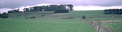 SW2 Landscape |
Soil Profile Morphology:
Surface Soil
| A11 | 0-15 cm | Black (10YR2/1); clay loam; strong medium polyhedral, parting to strong fine polyhedral structure; weak consistence moist; pH 7.6; gradual change to: | 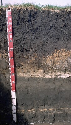 SW2 Profile |
| A12 | 15-25 cm | Black (10YR2/1) clay loam; strong medium polyhedral, parting to strong fine polyhedral structure; weak consistence moist; pH 7.8; clear to gradual change to: | |
| Subsoil | |||
| B21 | 25-45 cm | Black (10YR2/1) light medium clay; strong medium polyhedral, parting to strong fine polyhedral structure (smooth faced peds); weak consistence moist; pH 8.0; gradual change to: | |
| B22 | 45-60 cm | Dark brown (7.5YR3/2) light clay; moderate medium blocky, parting to strong fine subangular blocky structure; weak consistence moist; pH 8.1 ; abrupt change to: | |
The underlying horizons are layered tuff, volcanic ash and alluvial deposits of varying thickness. | |||
| D1 | 60-80 cm | Greyish brown (10YR5/2) clayey marl; weakly structured; very weak consistence moist; contains a few (10%) carbonate nodules (5 -15 mm size); pH 8.6; clear change to: | |
| D2 | 80-90 cm | Dark greyish brown (10YR4/2) fine sandy marl, structureless; very firm consistence moderately moist; abrupt change to: | |
| D3 | 90-100 cm | Very dark greyish brown (2.5Y3/2) fine sandy loam; structureless; pH 8.8; sharp change to: | |
| D4 | 100-102 cm | Carbonate layer | |
| D5 | 102-120 cm | Very dark grey (10YR3/1) fine sandy marl; very firm consistence, moderately moist; variably compacted; distinctly layered. | |
Key Profile Features:
- Texture contrast between surface (A) horizons and upper subsoil (B21) horizon.
- High organic matter content in surface horizons.
- Presence of old lake bed deposits from 60 cm depth.
Soil Profile Characteristics:
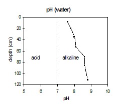
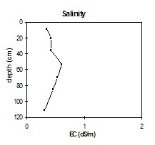
- | pH | Salinity | ||
Surface Soil (A11 horizon) | Slightly Alkaline | Medium | Non-Sodic | - |
Subsoil (25-45 cm) | Moderately Alkaline | Medium | Non-Sodic | None |
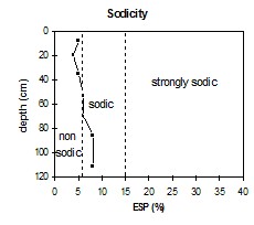
Deeper Subsoil (102-120 cm) | Strongly Alkaline | High | Sodic | None |
 |  |  | 
|
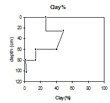
| The surface horizons are slightly alkaline. The subsoil is moderately alkaline. The marly D horizons are strongly alkaline. | The salinity rating is low-moderate for the upper 45 cm of the profile. The rating then becomes medium-high in the deeper subsoil before decreasing in the marl D horizons. | The surface horizons and upper subsoil are non-sodic. The deeper subsoil and marl D horizons are marginally sodic. | The clay percentage increases significantly at the A/B horizon interface |
| Horizon | Horizon Depth (cm) | pH (water) | pH (CaCl2) | EC dS/m | Organic Carbon % | Total Nitrogen % | Exchangeable Cations | Coarse Sand (0.2-2.0 mm) % | Fine Sand (0.02-0.2 mm) % | Silt (0.002-0.02 mm) % | Clay (<0.002 mm) % | Wilting Point % w/w | |||
| Ca | Mg | K | Na | ||||||||||||
| meq/100g | |||||||||||||||
| A11 | 0-15 | 7.6 | 7.0 | 0.35 | 6.0 | 0.62 | 42 | 13 | 0.72 | 2.9 | 8 | 20 | 22 | 27 | 39.7 |
| A12 | 15-25 | 7.8 | 7.3 | 0.43 | 4.5 | 47 | 12 | 0.58 | 2.2 | 8 | 21 | 24 | 26 | 32.6 | |
| B21 | 25-45 | 8.0 | 7.4 | 0.42 | 1.5 | 49 | 18 | 1.03 | 3.2 | 7 | 15 | 14 | 49 | 46.2 | |
| B22 | 45-60 | 8.1 | 7.6 | 0.61 | 48 | 25 | 0.99 | 4.8 | 6 | 16 | 22 | 41 | 47.6 | ||
| D1 | 60-80 | 8.6 | 7.9 | 0.53 | 49 | 24 | 0.45 | 4.6 | 3 | 18 | 12 | 14 | 27.6 | ||
| D2 | 80-90 | 8.6 | 8.0 | 0.46 | 43 | 18 | 0.63 | 5.3 | 15 | 39 | 7 | 2 | 21.8 | ||
| D5 | 102-120 | 8.8 | 8.1 | 0.31 | 29 | 8.3 | 0.79 | 3.2 | 17 | 46 | 2 | 3 | 12.6 | ||
© State of Victoria (Agriculture Victoria) 1996 - .

This work, Victorian Resources Online, is licensed under a Creative Commons Attribution 4.0 licence. You are free to re-use the work under that licence, on the condition that you credit the State of Victoria (Agriculture Victoria) as author, indicate if changes were made and comply with the other licence terms.
The licence does not apply to ‘branding’ or some ‘images or photographs’ that may be owned by third parties. We ask you to seek prior approval to use images using the VRO feedback form. Access to higher quality images can also be provided on request.
This page was last updated on .