
SW11
Location: Myamyn
Australian Soil Classification: Ferric, Mesotrophic, Brown CHROMOSOL
Northcote Factual Key: Dy3.41
Great Soil Group: podzolic
General Landscape Description: Gently undulating plain (slope 1%).
Geology: Probably weathered Quaternary basalt (Qvn) with residual ironstone on the surface, overlying Tertiary (Miocene) Port Campbell Limestone (Tmc).
Native Vegetation: Included Messmate (E. obliqua), Manna Gum (E. viminalis), Swamp Gum (E. ovata) and Shining Peppermint (E. nitida).
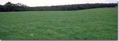 SW11 Landscape. |
Soil Profile Morphology:
Surface soil
| A11 | 0-15 cm | Very dark greyish brown (10YR3/2) sandy loam ; weak to moderate coarse blocky structure; very weak consistence moist; rusty root channel mottling present; pH 6.1; clear change to: | 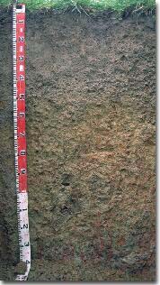 SW11 profile. |
| A21 | 15-35 cm | Brown (10YR5/3) conspicuously bleached (10YR7/3d) sandy loam; very weak consistence moist; rusty root channel mottling present; ferruginous nodules (5-10 mm size) common (10%); pH 5.6; clear and wavy change to: | |
| A22 | 35-50 cm | Brown (10YR6/3) conspicuously bleached (10YR7/3d) sandy loam; very weak consistence moist; contains many (40-60%) ironstone nodules (5-25 mm) pH 6.1; clear change to: | |
| Subsoil: | |||
| B21 | 50-85 cm | Yellowish brown (10YR5/4) with yellowish red (5YR5/8) mottles; medium clay; moderate coarse polyhedral parting to strong medium to fine polyhedral structure (shiny faced peds); firm consistence moist; contains few (5%) manganiferous stains; pH 6.2; clear change to: | |
| B22 | 85-110 cm | Yellowish brown (10YR5/4) with dark red (2.5YR4/8) and greyish brown (10YR5/2) mottles; light medium clay; shiny faced peds; very firm consistence moist; pH 6.1; gradual change to: | |
| B3 | 110 cm+ | Grey (10YR6/1) with dark red (2.5YR4/8) mottles; light medium clay; very firm consistence moist; pH 6.0. | |
A nearby bore provided the following stratigraphic information:
Bore Depth in Metres | Stratigraphy |
|
|
|
|
|
|
|
|
|
|
|
|
|
|
|
|
|
|
Key Profile Features:
- Strong texture contrast between surface (A) horizons (< 12% clay) and subsoil B21 horizon (69 % clay).
- Zone of ironstone nodules ('buckshot') in the subsurface (A2) horizons. This ironstone may be the residual of an old laterite layer.
Soil Profile Characteristics:
- | pH | Salinity | |
Surface Soil (A11 horizon) | Slightly Acid | High | Sodic |
Subsoil (50-85 cm) | Slightly Acid | Very Low | Sodic |
Deeper Subsoil (110 cm) | Moderately Acid | Low | Sodic |
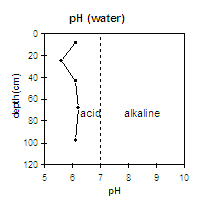 | 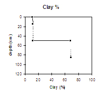 | 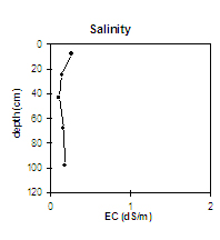 | . | |
| The surface soil is slightly acid and overlies a moderately acid subsurface (A21) horizon. The upper subsoil is slightly acid. | There is a large increase in clay content at the A/B horizon interface. | The salinity rating is low throughout the profile |
Horizon | Horizon Depth (cm) | pH (water) | pH (CaCl2) | EC dS/m | Sodium Chloride % | Exchangeable Cations | Coarse Sand (0.2-2.0 mm) % | Fine Sand (0.02-0.2 mm) % | Silt (0.002-0.02 mm) % | Clay (<0.002 mm) % | Wilting Point % w/w | |||
Ca | Mg | K | Na | |||||||||||
meq/100g | ||||||||||||||
A11 | 0-15 | 6.1 | 5.5 | 0.27 | 0.05 | 3.3 | 1.6 | 0.2 | 0.7 | 46 | 26 | 13 | 11 | 7 |
A21 | 15-35 | 5.6 | 4.9 | 0.15 | 0.9 | 0.6 | 0.1 | 0.4 | 46 | 28 | 13 | 12 | 4 | |
A22 | 35-50 | 6.1 | 5.2 | 0.11 | 0.9 | 0.8 | 0.1 | 0.4 | 5 | |||||
B21 | 50-85 | 6.2 | 5.9 | 0.17 | 3 | 4.4 | 0.2 | 0.8 | 16 | 11 | 6 | 69 | 23 | |
B22 | 85-110 | 6.1 | 6 | 0.19 | 3.1 | 5 | 0.3 | 0.8 | ||||||
B3 | 110+ | 6 | 6 | 0.19 | 2.7 | 5.2 | 0.2 | 0.8 | ||||||
Management Considerations:
Whole Profile
- Plant available water capacity (PAWC) is considered to be low (estimated at 65 mm) for the top metre of this soil profile. This is based on available laboratory data. It is estimated that 30% of this available water would be in the surface (A1) horizon.
- The subsurface (A2) horizons have an extremely low inherent fertility (based on the sum of the exchangeable basic cations).
- No dispersion occurs (even after remoulding) in the upper subsoil. This horizon is also well structured (parting down strongly to fine sized polyhedral shaped peds) and is not likely to restrict root and water movement.
- The subsoil has a low-moderate nutrient status (based on the sum of the exchangeable basic cations
- Salt problems can occur on lower slopes.
© State of Victoria (Agriculture Victoria) 1996 - .

This work, Victorian Resources Online, is licensed under a Creative Commons Attribution 4.0 licence. You are free to re-use the work under that licence, on the condition that you credit the State of Victoria (Agriculture Victoria) as author, indicate if changes were made and comply with the other licence terms.
The licence does not apply to ‘branding’ or some ‘images or photographs’ that may be owned by third parties. We ask you to seek prior approval to use images using the VRO feedback form. Access to higher quality images can also be provided on request.
This page was last updated on .