
WAS98 (Plot 4)
| Site: WAS98 (Plot 4) | Land Unit: Byaduk basalts |
| Aust. Soil Class.: | |
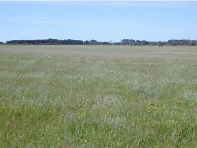 | General Land Unit Description: This land unit comprises the Quaternary lacustrine geology mainly north of the Glenelg River and around Balmoral. The landscape is generally gently undulating plains dissected with small clay plains. The soils in this land unit are similar to many of the soils in the study area – a strong textural contrast between the light textured topsoil and the sodic clay subsoil (Sodosol). The distinguishing feature of the soil type is the presence of an uncemented gravel (ironstone) above the clay, consisting mainly of ferruginised iron nodules mixed with indurated sandstone and manganese nodules. The presence of the bleached horizon (A2) and the mottles in the subsoil indicates impeded internal soil drainage. The presence of manganese flecks and nodules in some of the profiles may indicate the presence of a seasonally perched watertable. The subsoil is often sodic, and is also often strongly dispersive, destroying the structure of the subsoil and resulting in an evident large columnar or prismatic structure. Although often there can be secondary cracks in the large prisms or columns, it remains difficult for plant roots to penetrate deep into the subsoil. The dominant tree species located on this land unit is red gum. |
Site Description:
| Geology: Quaternary basalt | Internal drainage: Imperfectly drained |
| A1 | 0-35 cm | Very dark greyish brown (10YR3/2) sandy clay loam; weak polyhedral structure (20-50 mm) parting to weak polyhedral structure (5-10 mm); weak consistence when moderately moist; common very fine macropores; areal porosity 0.1%; many medium roots; clear and wavy transition to: | 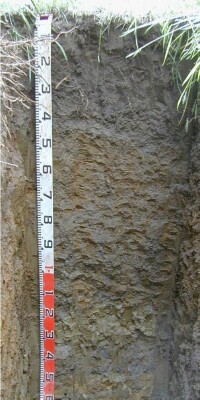 |
| A2 | 35-45 cm | Dark grey (10YR4/1) sandy clay loam; unable to assess structure, consistence or porosity due to very many segregations present; moderately moist; very many medium ferruginous nodules; common fine roots; abrupt and wavy transition to: | |
| Subsoil | |||
| B21 | 45-85 cm | Dark greyish brown (10YR4/2) with common medium faint strong brown (7.5YR5/6) mottles, medium heavy clay; weak polyhedral structure (20-50 mm); firm consistence when moderately moist; few medium ferruginous nodules; common very fine macropores; areal porosity 0.2%; few fine roots; diffuse and smooth transition to: | |
| B22 | 85-120 cm | Grey (10YR5/1) with common medium distinct strong brown (7.5YR5/6) mottles, medium heavy clay; weak polyhedral structure (20-50 mm) parting to weak polyhedral structure (5-10 mm); firm consistence when moderately moist; very few medium ferruginous nodules; many very fine macropores; areal porosity 0.4%; few very fine roots; diffuse and smooth transition to: | |
| B23 | 120-150 cm | Olive (5Y5/3) with common medium faint yellowish brown (10YR5/6) mottles, heavy clay; moderate angular blocky structure (50-100 mm) parting to weak polyhedral structure (5-10 mm); very firm consistence when moist; few very fine macropores; areal porosity 0.01%; few very fine roots. | |
| C | 150-170 cm | Yellow (5Y7/6) with many coarse faint olive yellow (2.5YR6/6) mottles, light clay; massive (brittle) structure; firm consistence when moderately moist; few very fine macropores; areal porosity 0.01%; few very fine roots. | |
| 170-200 cm | Similar to above, but an impeding layer at 200 cm, harder than C layer. Few remnant roots appear to have made their way through cracks in the weathering basalt rock. |
Notes:
Although an impeding layer exists at 200 cm, some root penetration through this layer ispossible.
Sampled by: Ian Sergeant, Paul Feikema and Martin Clark (31 October 2000)
© State of Victoria (Agriculture Victoria) 1996 - .

This work, Victorian Resources Online, is licensed under a Creative Commons Attribution 4.0 licence. You are free to re-use the work under that licence, on the condition that you credit the State of Victoria (Agriculture Victoria) as author, indicate if changes were made and comply with the other licence terms.
The licence does not apply to ‘branding’ or some ‘images or photographs’ that may be owned by third parties. We ask you to seek prior approval to use images using the VRO feedback form. Access to higher quality images can also be provided on request.
This page was last updated on .