
Site GL155
Location: Coleraine.
Australian Soil Classification: Endocalcareous, Self-mulching, Black VERTOSOL (confidence level 1).
Land Mapping Unit: Dundas Trachyte. Dundas Tablelands (land unit).
General Land Unit Description: There are a few isolated outcrops of Jurassic trachyte in the north-western portion of the Glenelg-Hopkins region, with the largest outcrop occurring north east of Coleraine. There are also some colluvial slopes on the edge of trachyte outcrops around the Dundas and Merino Tablelands.
The trachyte hills often have rock outcrop and reasonably shallow soils on the crests and upper slopes. The main soil type on the upper slopes is a Brown Sodosol although Chromosols also occur which are commonly sodic at depth. The soils on the colluvial slopes tend to be black cracking clays (Vertosols) or Black Vertic Sodosols. These soils are similar to the black soils of the dissected Merino Tablelands land unit. The soils on these slopes are a complex mix of different soil forming processes.
This site is situated on the edge of the Tablelands. It is on a mid-slope leading to an alluvial valley. The landscape of the Tablelands is very dissected and variable. The soils on this site are a complex mix resulting from different soil forming processes. The surface soil is of volcanic origin. This occurs over a narrow band of Cretaceous sediments which overlie highly weathered sandy rhyolite. The basalt soil is a black cracking clay with a self-mulching topsoil. Large surface cracks are evident. As a result of the heavy clay soil, profile drainage is imperfect. There are many rusty root channel mottles throughout the profile which is an indication of this.
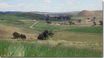 Site GL155 Landscape |
| Site Description: Slope: 18% Geology: Jurassic trachyte. Landform Pattern: Low hills and rises. Position in Landscape: Mid slope. Internal Drainage: Imperfectly drained. |
Surface Soil
| A1 | 0-10 cm | Black (10YR2/1) light clay; strong very fine sub-angular blocky structure; self-mulching surface condition; pH 5.8; clear change to: | 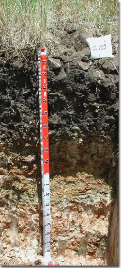 Site GL155 Profile |
| Subsoil | |||
| B21 | 10-30 cm | Black (10YR2/1) heavy clay with many distinct; medium yellow and orange mottles; strong medium lenticular, parting to strong fine polyhedral structure; slickensides are evident, a few basalt and rhyolite coarse fragments (60-200 mm); pH 6.6; gradual and wavy change to: | |
| B22 | 30-55 cm | Dark greyish brown (2.5Y4/2) heavy clay; many distinct medium yellow and orange mottles; strong medium lenticular, parting to strong fine polyhedral structure; a few basalt and rhyolite coarse fragments (60-200 mm); black organic veins evident due to cracking; pH 7.1; gradual change to: | |
| BC | 55-70 cm | Olive brown (2.5Y4/3) heavy clay; many distinct orange, yellow and red mottles (derived from weathered rock); strong fine polyhedral structure; few soft calcareous segregations occurring in patches; a few basalt and rhyolite coarse fragments (60-200 mm); black veins evident due to cracking; pH 8.1; clear and wavy change to: | |
| C | 70-110 cm | Weathered trachyte/basalt rock; soft calcareous segregations occurring in patches are common; many basalt and rhyolite coarse fragments (20-60 mm); abrupt change to: | |
| D1 | 110-135 cm | A thin band of Cretaceous sediments. | |
| D2 | 135-180+ cm | Weathered rhyolite; massive sandy structure. | |
Key Profile Features:
- Clay throughout.
- Soil cracks when dry.
- Shallow surface horizons.
- Surface soil dispersive when remoulded (worked when wet).
- Mottled subsoil.
- Subsoil dispersive when remoulded (worked when wet).
- Alkaline subsoil.
- Calcareous at depth.
Soil Profile Characteristics:
pH | Salinity Rating | |||
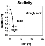
Surface (A1 horizon) | Moderately Acid | Low | Non-Sodic | None |
Upper Subsoil (10-30 cm) | Slightly Acid | Low | Non-Sodic | None 1 |
Deeper subsoil (at 55-70 cm) | Moderately Alkaline | Low | None | None |
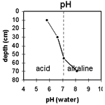 | 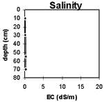 |  |  |
Horizon | Horizon Depth (cm) | pH (water) | pH (CaCl2) | EC 1:5 | Exchangeable Cations | |||
Ca | Mg | K | Na | |||||
meq/100g | ||||||||
A1 | 0-10 | 5.8 | 5.1 | 0.11 | 14 | 9.6 | 19 | 0.35 |
B21 | 10-30 | 6.6 | 5.7 | 0.13 | 18 | 16 | 1.1 | 1.0 |
B22 | 30-55 | 7.1 | 6.3 | 0.29 | 21 | 25 | 1.2 | 1.6 |
B3 | 55-70 | 8.1 | 7.5 | 0.34 | 24 | 23 | 0.6 | 2.0 |
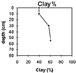
Horizon | Horizon Depth (cm) | Exchangeable Aluminium mg/kg | Exchangeable Acidity meq/100g | Field Capacity pF2.5 | Wilting Point pF4.2 | Coarse Sand (0.2- 2.0 mm) | Fine Sand (0.02- 0.2 mm) | Silt (0.002- 0.02 mm) | Clay (<0.002 mm) |
A1 | 0-10 | 14 | 17 | 37 | 24 | 8 | 23 | 16 | 40 |
B21 | 10-30 | 18 | 14 | 53 | 33 | 4 | 20 | 12 | 57 |
B22 | 30-55 | 66 | 37 | 4 | 16 | 12 | 61 | ||
B3 | 55-70 | 56 | 33 |
Profile Described By:
© State of Victoria (Agriculture Victoria) 1996 - .

This work, Victorian Resources Online, is licensed under a Creative Commons Attribution 4.0 licence. You are free to re-use the work under that licence, on the condition that you credit the State of Victoria (Agriculture Victoria) as author, indicate if changes were made and comply with the other licence terms.
The licence does not apply to ‘branding’ or some ‘images or photographs’ that may be owned by third parties. We ask you to seek prior approval to use images using the VRO feedback form. Access to higher quality images can also be provided on request.
This page was last updated on .