
PHO99 (Plot 1)
| Site: PHO99 (Plot 1) | Land Unit: Strathdownie |
| Aust. Soil Class.: | |
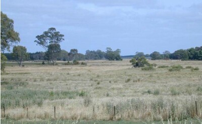 | General Land Unit Description: This land unit comprises the Quaternary lacustrine geology south of the Glenelg River. The lacustrine deposits include lagoonal, swamp and local colluvial deposits formed in low-lying wetlands and depressions between stranded beach ridges. Parent material in this land unit comprises of sand, silt, sandy clay, peat, marl and freshwater limestone, occurring in relatively unconsolidated forms. The soils are variable throughout this land unit due to varying depositional environments. A common soil type is a strong texture contrast soil (Chromosol, Sodosol) commonly with a bleached A2 horizon and a mottled subsoil (indicative of impeded internal drainage). The sandy topsoil can be very deep in some soils. Vertosols are also common on the plains and swales in between the dunes. Podosols occur on the flats as well as on the dunes and that may have been mapped as part of this land unit due to restrictions of scale. Many of the soils are poorly drained and exhibit signs of a perched watertable. 1.5 year old Eucalyptus globulus plantation on ex-agricultural land. Remnant roots were observed to 150 cm, the pockets of dark grey sand in the B21 and B22 layers may have arisen due to previous (now remnant) root activity. |
Site Description:
| Geology: Quaternary lacustrine | Landform pattern: Level plains |
| Position in landscape: Flat | Internal drainage: Imperfectly drained |
| A1 | 0-20 cm | Very dark greyish brown (10YR3/2) loamy sand; single grain structure; very weak consistence when dry; common medium roots; clear and smooth transition to: | 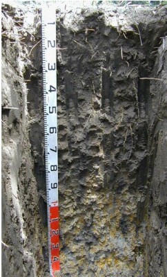 |
| A2 | 20-55 cm | Dark greyish brown (10YR4/2) loamy sand; single grain structure; loose consistence when moderately moist; common medium roots; clear and smooth transition to: | |
| A3 | 55-80 cm | Dark grey (10YR4/1) with many coarse faint dark yellowish brown (10YR4/4) sandy loam; weak subangular blocky structure (20-50 mm); loose consistence when moist; few fine roots; clear and smooth transition to: | |
| Subsoil | |||
| B1 | 80-100 cm | Grey (10YR6/1) with many coarse distinct yellowish brown (10YR5/6) mottles and dark grey sand (10YR4/1) on ped faces, sandy clay; weak subangular blocky structure (20-50 mm) parting to weak subangular blocky structure (10-20 mm); very weak consistence when moist; many very fine macropores; areal porosity 0.6%; no roots observed; clear and smooth transition to: | |
| B21 | 100-140 cm | Grey (10YR6/1) with many coarse distinct brownish yellow (10YR6/8) mottles and dark grey sand (10YR4/1) pockets, medium heavy clay (with sand); weak subangular blocky structure (20-50 mm) parting to weak subangular blocky structure (10-20 mm); very weak consistence when moist; few coarse ferruginous nodules; common fine macropores; areal porosity 0.3%; no roots observed; diffuse and smooth transition to: | |
| B22 | 140-150 cm | Grey (10YR6/1) with many coarse distinct brownish yellow (10YR6/8) mottles and dark grey sand (10YR4/1) pockets, medium clay (with sand); weak subangular blocky structure (20-50 mm) parting to weak subangular blocky structure (10-20 mm); very weak consistence when wet; common extremely coarse calcareous nodules (soft and hard); few very fine macropores; areal porosity 0.08%; no roots observed. | |
| 150-230 cm | Grey medium clay with sand, sand pipes to 300 cm, zones of sand along cracks (50 mm width) | ||
| 230-380 cm | Grey clayey sand. | ||
| 380-400 cm | Heavy grey/yellow/brown clay. |
Sampled by: Ian Sargeant, Paul Feikema and Martin Clark (5 December 2000)
© State of Victoria (Agriculture Victoria) 1996 - .

This work, Victorian Resources Online, is licensed under a Creative Commons Attribution 4.0 licence. You are free to re-use the work under that licence, on the condition that you credit the State of Victoria (Agriculture Victoria) as author, indicate if changes were made and comply with the other licence terms.
The licence does not apply to ‘branding’ or some ‘images or photographs’ that may be owned by third parties. We ask you to seek prior approval to use images using the VRO feedback form. Access to higher quality images can also be provided on request.
This page was last updated on .