
MM652
| Site: MM652 | Land Unit: Warrabkook Basalts |
| Aust. Soil Class.: Ferric, ?, Brown KUROSOL (confidence level 3) | |
| General Land Unit Description: This land unit consists of gently undulating basalt plains in the Macarthur area. In some drainage lines, the basalt has been dissected sufficiently to expose the underlying sediments. The soils on the basalt plains are commonly Brown Kurosols or Chormosols, intermixed with Sodosols, particularly on the lower slopes and drainage depressions. |
Site Description:
| Geology: Quaternary basalt | Landform pattern: Undulating plains |
| Position in landscape: Crest / rise | Internal drainage: Imperfectly well drained |
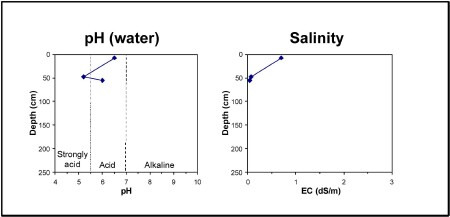
| A11 | 0-15 cm | Very dark greyish brown (10YR3/2) sandy clay loam, hard setting surface, apedal, pH 6.5. Clear transition to: |
| A12 | 15-40 cm | Dark brown (10YR3/3) fine sandy clay loam, ferromanganiferous nodules are abundant. Sharp transition to: |
| Subsoil | ||
| B21 | 40-55 cm | Yellowish brown (10YR5/6) medium clay, red mottles, pH 5.2:[ |
| B22 | 55+ cm | Yellowish brown (10YR5/6) medium clay, red mottles, a few basalt fragments (200-600 mm), pH 6.0. |
Key profile features:
- Topsoil dispersive when dry
- Strongly acidic subsoil
- Ferromanganiferious are abundant in A2 horizon
- Mottled subsoil
© State of Victoria (Agriculture Victoria) 1996 - .

This work, Victorian Resources Online, is licensed under a Creative Commons Attribution 4.0 licence. You are free to re-use the work under that licence, on the condition that you credit the State of Victoria (Agriculture Victoria) as author, indicate if changes were made and comply with the other licence terms.
The licence does not apply to ‘branding’ or some ‘images or photographs’ that may be owned by third parties. We ask you to seek prior approval to use images using the VRO feedback form. Access to higher quality images can also be provided on request.
This page was last updated on .