
MM448
| Site: MM448 | Land Unit: Purnin-Bushfield Basalts |
| Aust. Soil Class.: Ferric-Sodic, ?, Black CHROMOSOL (confidence level 3) | |
| General Land Unit Description: The gently undulating basalt plains in the Purnim – Bushfield area, east of Warrnambool, consist of an association of Brown and Black Chromosols and Sodosols. Many of the soils have abundant levels of ferromanganiferous nodules, either at depth or above the clay. Floating rocks and stones throughout the profile can also occur. There are minor occurrences of Black Vertosols, particularly in close proximity to the valley walls and slopes adjacent to the Merri River and Drysdale Creek. |
Site Description:
| Geology: Quaternary basalt | Landform pattern: Gently undulating to level plain |
| Position in landscape: Upper slope | Internal drainage: Imperfectly drained |
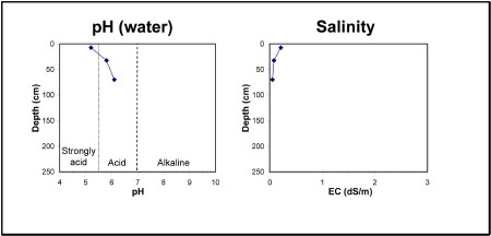
| A1 | 0-15 cm | Black (10YR2/1) clay loam, hard setting surface, apedal, firm consistence when dry, pH 5.2. Sharp transition to: |
| Subsoil | ||
| B21 | 15-50 cm | Very dark brown (10YR2/2) medium clay, strong blocky structure (5-10 mm), pH 5.8. Clear transition to: |
| B22 | 50-70 cm | Very dark brown (10YR2/2) medium clay, moderate blocky structure (5-10 mm), coarse fragments (>600 mm) are common. Gradual transition to: |
| B23 | 70+ cm | Yellowish brown (10YR5/6), medium clay, ferromanganiferous nodules are abundant, pH 6.1. |
Key profile features:
- Strongly acidic topsoil
- Strong texture contrast between topsoil and subsoil
- Floating rocks and stones are common
- Ferromanganiferious nodules are abundant at depth
- Deeper subsoil dispersive when dry
© State of Victoria (Agriculture Victoria) 1996 - .

This work, Victorian Resources Online, is licensed under a Creative Commons Attribution 4.0 licence. You are free to re-use the work under that licence, on the condition that you credit the State of Victoria (Agriculture Victoria) as author, indicate if changes were made and comply with the other licence terms.
The licence does not apply to ‘branding’ or some ‘images or photographs’ that may be owned by third parties. We ask you to seek prior approval to use images using the VRO feedback form. Access to higher quality images can also be provided on request.
This page was last updated on .