
MM247
| Site: MM247 | Land Unit: Willaura Basalt |
| Aust. Soil Class.: Ferric, Mottled-Mesonatric, Brown SODOSOL (confidence level 2) | |
| General Land Unit Description: This land unit occurs on the level to gently undulating plains between Moyston and Willarua. The soils are commonly sodic and exhibit gilgai micro-relief, although due to land management, gilgais are not always apparent on the surface. Soil depth is variable due to basalt floaters. On the broad flat crest and level areas, particularly in the southern portion of the land unit, the soils can have a conspicuously bleached A2 horizon. Numerous grey clay swamps and depressions are scattered throughout this map unit. Occasionally Red or Brown Chromosols or Sodosols may be found on backs surround these swamps. |
Site Description:
| Geology: Quaternary basalt | Landform pattern: Gently undulating to level plain |
| Position in landscape: Flat | Internal drainage: Imperfectly drained |
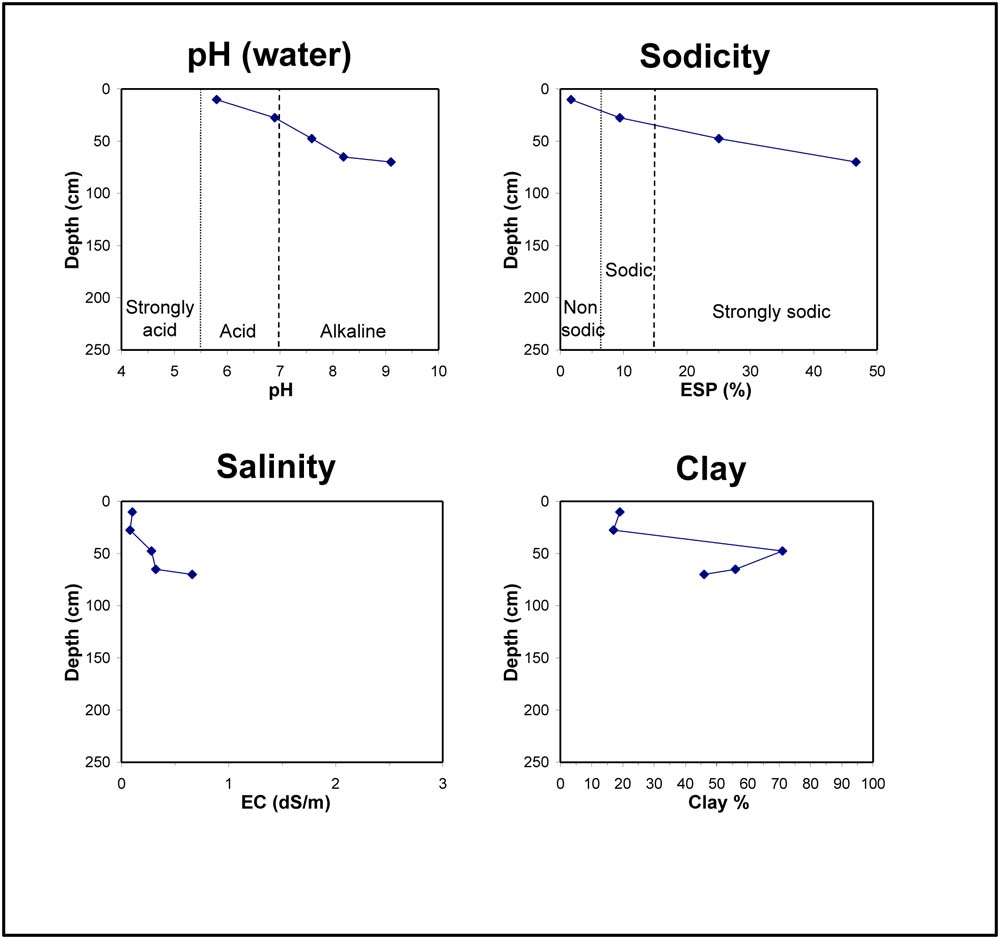
| A11 | 0-20 cm | Dark brown (10YR3/3) clay loam, weak consistence when moderately moist, pH 5.8, sharp transition to: |
| A12 | 20-35 cm | Pale brown (10YR6/3) clay loam, conspicuously bleached (10YR8/2) when dry, weak consistence when dry, ferromanganiferous nodules are abundant, pH 6.9, sharp transition to: |
| Subsoil | ||
| B21 | 35-60 cm | Yellowish brown (10YR5/4) heavy clay, reddish brown mottles, very firm consistence when moist, pH 7.6, clear transition to: |
| B22 | 60-70 cm | Brown (10YR5/3) medium clay, very firm consistence when moist, pH 8.2, gradual transition to: |
| B23 | 70+ cm | Light yellowish brown (2.5Y6/4) medium clay, very firm consistence when moist, calcareous segregations, pH 9.1. |
Key profile features:
- Strongly alkaline at depth
- Strongly sodic subsoil
- Calcareous segregations in subsoil
- Ferromanganiferious nodules are abundant above the clay
© State of Victoria (Agriculture Victoria) 1996 - .

This work, Victorian Resources Online, is licensed under a Creative Commons Attribution 4.0 licence. You are free to re-use the work under that licence, on the condition that you credit the State of Victoria (Agriculture Victoria) as author, indicate if changes were made and comply with the other licence terms.
The licence does not apply to ‘branding’ or some ‘images or photographs’ that may be owned by third parties. We ask you to seek prior approval to use images using the VRO feedback form. Access to higher quality images can also be provided on request.
This page was last updated on .