
HUN99 (Plot 5)
| Site: HUN99 (Plot 5) | Land Unit: Strathdownie |
| Aust. Soil Class.: | |
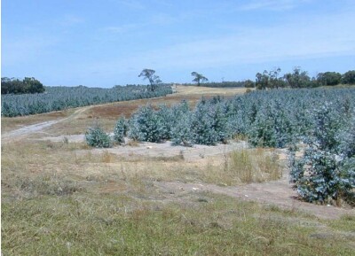 |
The majority of this land unit falls south of the Kanawinka fault. This land unit comprises areas with deep sand deposits. The residual landscape is thought to be influenced by the retreat of the Murray Sea which left stranded beach ridges oriented south west–north east. These were subsequently covered by superficial sand sheets in later depositional phases, which formed the landscape seen today. The major landforms in this land unit are dunes and swales. Podosols and Kurosols or Chromosols are the major soil types found on the dunes and rises. Podosols are soils with a ‘coffee rock’ layer (refer to photograph). The Kurosols or Chromosols tend to have a deep sandy topsoil over the clay. The common soil types on the swales are black cracking clay (Vertosols) or Grey Sodosols. Some Ferric Kurosols or Chromosols can also occur on the swales or lower slopes of the dunes. 1.5 year old Eucalyptus globulus plantation on ex-agricultural land |
Site Description:
| Geology: Quaternary aeolian | Landform pattern: Gently undulating plain |
| A1 | 0-15 cm | Very dark grey (10YR3/1) loamy fine sand; single grain structure; loose consistence when moderately moist; unable to assess macroporosity due to sandy structure; many medium roots; abrupt and smooth transition to: | 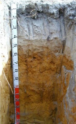 |
| A21 | 15-30 cm | Light grey (10YR7/2) fine sand; single grain structure; loose consistence when moderately moist; unable to assess macroporosity due to sandy structure; common medium roots; clear and smooth transition to: | |
| A22 | 30-45 cm | Light grey (10YR7/2) with many very coarse light grey (10YR7/1) mottles, fine sand; single grain structure; loose consistence when moderately moist; unable to assess macroporosity due to sandy structure; common medium roots; clear and wavy transition to: | |
| Subsoil | |||
| B21 | 45-130 cm | Brownish yellow (10YR6/8) fine sand; single grain structure; loose consistence when moderately moist; unable to assess macroporosity due to sandy structure; few ferruginous very coarse nodules (iron cemented sands); common medium roots; clear and smooth transition to: | |
| B22 | 130-150 cm | Yellow (10YR8/6) fine sand; single grain structure; loose consistence when moist; unable to assess macroporosity due to sandy structure; no roots observed. | |
| 150-290 cm | Sands, increasing moisture with depth, pit collapsed. |
© State of Victoria (Agriculture Victoria) 1996 - .

This work, Victorian Resources Online, is licensed under a Creative Commons Attribution 4.0 licence. You are free to re-use the work under that licence, on the condition that you credit the State of Victoria (Agriculture Victoria) as author, indicate if changes were made and comply with the other licence terms.
The licence does not apply to ‘branding’ or some ‘images or photographs’ that may be owned by third parties. We ask you to seek prior approval to use images using the VRO feedback form. Access to higher quality images can also be provided on request.
This page was last updated on .