
HET99 (Plot 1)
| Site: HET99 (Plot 1) | Land Unit: Strathdownie |
| Aust. Soil Class.: | |
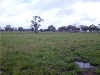 |
This land unit comprises the Quaternary lacustrine geology south of the Glenelg River. The lacustrine deposits include lagoonal, swamp and local colluvial deposits formed in low-lying wetlands and depressions between stranded beach ridges. Parent material in this land unit comprises of sand, silt, sandy clay, peat, marl and freshwater limestone, occurring in relatively unconsolidated forms. The soils are variable throughout this land unit due to varying depositional environments. A common soil type is a strong texture contrast soil (Chromosol, Sodosol) commonly with a bleached A2 horizon and a mottled subsoil indicative of impeded internal drainage). The sandy topsoil can be very deep in some soils. Vertosols are also common on the plains and swales in between the dunes. Podosols occur on the flats as well as on the dunes and that may have been mapped as part of this land unit due to restrictions of scale. Many of the soils are poorly drained and exhibit signs of a perched watertable. 1.5 year old E. globulus plantation on ex-agricultural land. As second pit was dug across a row of trees nearby, and revealed that the pan was not broken by the ripper, and no roots were observed below the pan. |
Site Description:
| Geology: Quaternary lacustrine | Landform pattern: Level plains |
| Position in landscape: Flat | Internal drainage: Poorly drained |
| A1 | 0-20 cm | Very dark grey (10YR3/1) sand; single grain structure; loose consistence when moist; common medium roots; clear and smooth transition to: | 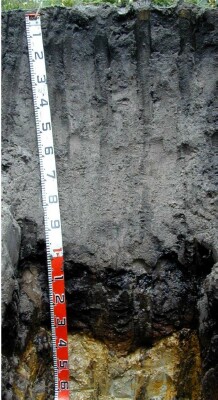 |
| A2 | 20-90 cm | Grey (10YR6/1) sand; single grain structure; loose consistence when moist; few very fine roots; abrupt and wavy transition to: | |
| Subsoil | |||
| Bh | 90-95 cm | Black (10YR2/1) sand; single grain structure; very weak consistence when wet; unable to estimate macroporosity due to single grain structure; no roots observed; free water oozing out of pit wall; clear and wavy transition to: | |
| Bhs | 95-120 cm | Very dark brown (10YR2/2) sand; single grain structure; strong consistence when moist; continuous massive moderately cemented orstein pan; unable to estimate macroporosity due to single grain structure; no roots observed; sharp and wavy transition to: | |
| B2 | 120-160 cm | Light grey (10YR7/1) with many coarse distinct yellowish brown (10YR5/6) mottles, medium heavy clay (with sand); weak angular blocky structure (50-100 mm); firm consistence when moist; few very fine macropores; areal porosity 0.01%; few very fine roots. | |
| 160-260 cm | Similar as layer above. | ||
| 260-330 cm | Sandy clay. | ||
| 330-410 cm | Clayey sand, soft calcium carbonate pockets below 350 cm, remnant roots to 410 cm, free water slowly seeping into bottom of pit. |
© State of Victoria (Agriculture Victoria) 1996 - .

This work, Victorian Resources Online, is licensed under a Creative Commons Attribution 4.0 licence. You are free to re-use the work under that licence, on the condition that you credit the State of Victoria (Agriculture Victoria) as author, indicate if changes were made and comply with the other licence terms.
The licence does not apply to ‘branding’ or some ‘images or photographs’ that may be owned by third parties. We ask you to seek prior approval to use images using the VRO feedback form. Access to higher quality images can also be provided on request.
This page was last updated on .