
Site SW20
Location: Glenormiston College.
Australian Soil Classification: Melanic, Eutrophic, Black FERROSOL
Northcote Factual Key: Gn3.42
Great Soil Group: no suitable group
Geology: Quaternary volcanic scoriaceous deposits derived from Mt. Noorat.
General Landscape Description: Lower slope below Mt. Noorat.
Site Description: Roadside reserve.
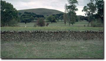 Site SW20 Landscape |
Soil Profile Morphology:
Surface Soil
| A1 | 0-25 cm | Dark brown (7.5YR3/2); heavy clay loam; strong medium polyhedral, parting to strong fine polyhedral structure; pH 6.2; gradual change to: | 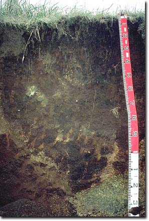 Site SW20 Profile |
| Subsoil | |||
| B1 | 25-65 cm | Dark brown (7.5YR3/2); heavy clay loam; strong medium polyhedral, parting to fine polyhedral structure; contains scattered inclusions; pH 6.7: | |
| B21 | 65-95 cm | Dark brown (7.5YR3/2); light medium clay; strong coarse polyhedral, parting to fine polyhedral structure; at 80-90 cm depth there is occasional dark reddish brown (5YR3/3) piping; pH 7.2: | |
| Note: Scoria accumulations occur between 50 and 100 cm depth. Redder variation on the other side of the pit. | |||
Key Profile Features:
- Little change in clay content throughout the profile.
- Variable scoria accumulations between 50 to 100 cm in depth.
pH | Salinity Rating | |||
Surface (A1 horizon) | slightly acid | low | non-sodic | none |
Subsoil (B1 horizon) | slightly acid | very low | non-sodic | none 1 |
Deeper subsoil (at 80 cm) | slightly alkaline | very low | non-sodic | none 1 |
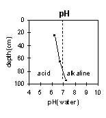 | 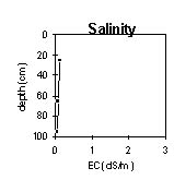 | 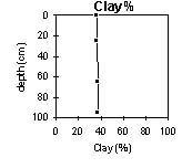 |
| The profile is slightly acid becoming slightly alkaline at 80 cm depth. | The salinity rating is low to very low throughout the profile. | Clay content increases only slightly down the profile. |
Horizon | Horizon Depth (cm) | pH (water) | pH (CaCl2) | EC 1:5 | Exchangeable Cations | |||
Ca | Mg | K | Na | |||||
meq/100g | ||||||||
A1 | 0-25 | 6.2 | 5.6 | 0.12 | 13 | 6.7 | 2.5 | 0.47 |
B1 | 25-65 | 6.7 | 5.9 | 0.06 | 11 | 7.3 | 1.9 | 0.4 |
B21 | 65-95 | 7.2 | 6.1 | 0.05 | 11 | 9.4 | 0.63 | 0.89 |
Horizon | Horizon Depth (cm) | Wilting Point pF4.2 | Coarse Sand (0.2- 2.0 mm) | Fine Sand (0.02- 0.2 mm) | Silt (0.002- 0.02 mm) | Clay (<0.002 mm) |
A1 | 0-25 | 24 | 10 | 18 | 24 | 36 |
B1 | 25-65 | 18 | 11 | 21 | 22 | 37 |
B21 | 65-95 | 20 | 12 | 21 | 20 | 37 |
Management Considerations:
Whole Profile
- Plant available water capacity (PAWC) is considered to be low-medium (estimated at 97 mm). This is based on available laboratory data and assumes an effective rooting depth of 100 cm. Effective plant available water in the subsoil will be higher for this profile compared to sites SW17 and SW18 as the subsoil is non-sodic and has better structure.
- The soil profile has a relatively high level of exchangeable calcium. This promotes flocculation of clays and results in the soil being well structured (parting down strongly into fine sized polyhedral shaped peds) and having a weak consistence when moist. These conditions are very favourable for root and water movement down the profile. The high organic matter levels in the upper soil profile also contribute to favourable soil structure.
- The soil profile also has a high free iron oxide content (5.5% in the B21 horizon) which also contributes to the well-developed structure. However, the free iron oxide will tend to ‘fix’ phosphorus which makes it less available to plants. Regular phosphorus application will assist in overcoming such a deficiency. Zinc and copper can also be ‘fixed’ by high iron oxide contents.
- The pH range for this profile ranges from 6.2 at the surface to 7.2 at depth, which is ideal for plant growth.
- The profile has a high inherent fertility based on the sum of the exchangeable cations (Ca, Mg, K).
- The levels of total nitrogen measured at this pit site are high. However, this is best assessed by taking a bulked sample from across the paddock.
© State of Victoria (Agriculture Victoria) 1996 - .

This work, Victorian Resources Online, is licensed under a Creative Commons Attribution 4.0 licence. You are free to re-use the work under that licence, on the condition that you credit the State of Victoria (Agriculture Victoria) as author, indicate if changes were made and comply with the other licence terms.
The licence does not apply to ‘branding’ or some ‘images or photographs’ that may be owned by third parties. We ask you to seek prior approval to use images using the VRO feedback form. Access to higher quality images can also be provided on request.
This page was last updated on .