
Site SW17
Location: Glenormiston College (North Farm).
Australian Soil Classification: Vertic, Mottled-Mesonatric, Black SODOSOL
Northcote Factual Key: Dd2.22
Great Soil Group: solodic
Geology: Quaternary basalt (Qvn).
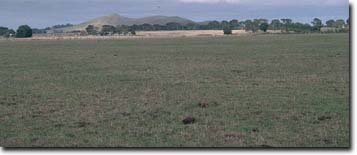
General Landscape Description: Level Plain.
Site Description: Roadside reserve adjacent to a grazing paddock.
 Site SW17 Landscape |
Soil Profile Morphology:
Surface Soil
| A11 | 0-15 cm | Very dark greyish brown (10YR3/2); fine sandy clay loam; strong fine polyhedral structure; very weak consistence slightly moist; slightly hydrophobic; pH 5.5; abrupt change to: | 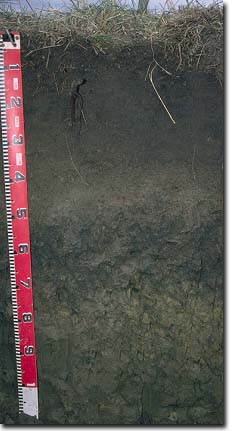 Site SW17 Profile |
| A12 | 15-30 cm | Very dark grey (10YR3/1); fine sandy clay loam; moderate polyhedral, parting to fine polyhedral structure; very weak consistence slightly moist; pH 5.7; clear change to: | |
| A2 | 30-45 cm | Very dark greyish brown (10YR3/2); fine sandy clay loam; weak consistence slightly moist; contains very many (75%) ferruginous gravels; pH 6.3; abrupt change to: | |
| Subsoil | |||
| B21 | 45-70 cm | Very dark grey (10YR3/1) with common (10 -20%) yellowish red (5YR5/8) mottles and a few (10%) red mottles; heavy clay; moderate coarse polyhedral, parting to moderate fine polyhedral structure; shiny faced peds; very firm consistence moist; contains a few (5%) ferromanganiferous nodules (2-6 mm in size); pH 7.0; gradual and wavy change to: | |
| B22 | 70-110 cm | Dark yellowish brown (10YR4/4) with dark greyish brown (10YR4/2) mottles; rusty root channel mottling present; heavy clay; coarse lenticular structure, parting to coarse prismatic structure; coarse slickensides present; strong consistence slightly moist; contains a few (5%) ferromanganiferous nodules (2-6 mm in size); pH 7.5. |
Key Profile Features:
- Strong texture contrast between surface (A) horizons (< 26% clay) and the sodic subsoil (B21) horizon (75% clay).
- Vertic properties i.e. significant shrink-swell characteristics in the subsoil.
pH | Salinity Rating | |||
Surface (A11 horizon) | strongly acid | very low | non-sodic | none |
Subsoil (B21 horizon) | neutral | very low | sodic | strong |
Deeper subsoil (at 90 cm) | slightly alkaline | very low | strongly sodic | strong |
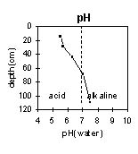 | 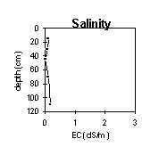 | 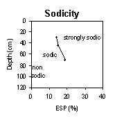 | 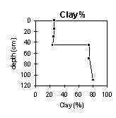 |
The surface is strongly acid. The subsoil is neutral becoming slightly alkaline at 90 cm. | The salinity rating is very low throughout the profile. | The upper surface horizon is non-sodic. The subsoil is sodic, becoming strongly sodic at 60 cm. | There is an abrupt increase in clay content at the A/B horizon interface. |
Horizon | Horizon Depth (cm) | pH (water) | pH (CaCl2) | EC 1:5 | Exchangeable Cations | |||
Ca | Mg | K | Na | |||||
meq/100g | ||||||||
A11 | 0-15 | 5.5 | 4.7 | 0.09 | 5.5 | 3.1 | 0.37 | 0.43 |
A12 | 15-30 | 5.7 | 4.7 | 0.06 | 4.7 | 2.8 | 0.18 | 0.38 |
A2 | 30-45 | 6.3 | 5 | <0.05 | 2.7 | 2.6 | 0.12 | 0.42 |
B21 | 45-70 | 7 | 5.7 | 0.09 | 6.6 | 14 | 0.34 | 3.6 |
B22 | 70-110 | 7.5 | 6.5 | 0.17 | 7.3 | 16 | 0.39 | 5.3 |
Horizon | Horizon Depth (cm) | Wilting Point pF4.2 | Coarse Sand (0.2- 2.0 mm) | Fine Sand (0.02- 0.2 mm) | Silt (0.002- 0.02 mm) | Clay (<0.002 mm) |
A11 | 0-15 | 16 | 7 | 35 | 22 | 26 |
A12 | 15-30 | 13 | 11 | 36 | 24 | 25 |
A2 | 30-45 | 11 | 22 | 33 | 19 | 24 |
B21 | 45-70 | 34 | 4 | 10 | 5 | 75 |
B22 | 70-110 | 37 | 2 | 7 | 4 | 80 |
Management Considerations:
Whole Profile
- Plant available water capacity (PAWC) is considered to be low (estimated at 88 mm). This is based on available laboratory data and assumes an effective rooting depth of 70 cm. Rooting depth will be restricted by the dense, coarsely structured and strongly sodic deeper subsoil. The availability of moisture to the plant depends to a large degree on soil structure and consistence. In dense and coarsely structured subsoils such as these, it is likely that there will be a large amount of unused ‘available’ moisture in the subsoil. Effective PAWC is therefore likely to be lower than estimated above.
- Water movement will be restricted by the dense, sodic subsoil and drainage may be required to prevent waterlogging.
- The soil profile has a high level of exchangeable magnesium throughout. Values of the ratio of exchangeable magnesium to CEC of greater than 20% may induce potassium deficiency in some soils (Baker and Eldershaw, 1993).
- The surface (A11) horizon has a high fine sand (35%) and silt (22%) content. Soils such as these rely to a large extent on organic matter for maintaining aggregation. At low organic matter levels structural deterioration e.g. exacerbated hardsetting, surface sealing and compaction, is more likely to occur particularly if cultivation takes place. The surface soil is likely to suffer structural deterioration e.g. compaction, pugging, if overstocking occurs whilst the soil is wet. The levels of organic carbon measured at this pit site in the roadside reserve is high but will not be representative of the adjacent paddock.
- The surface horizon (A1) is strongly acid. This indicates that aluminium and manganese toxicity may occur. The level of exchangeable aluminium measured at this site is not high (22 ug/kg), but this may not be representative. A pH/aluminium test is best performed from samples taken across the paddock and bulked together. Lime can be an effective ameliorant for acid soils. However, other factors need to be considered before lime is recommended e.g. pasture species grown, method of application, local trial responses, soil surface structure and likely cost/benefit.
- Deficiencies in molybdenum, potassium and phosphorus are likely to occur in strongly acid soils. If lime is required, an application may assist in alleviating molybdenum deficiency and will increase phosphorus availability, as well as increasing soil pH.
- Manganese toxicity can also occur in strongly acid soils, particularly when poorly drained as waterlogging may bring manganese into solution.
- The surface soil has a low-moderate inherent fertility based on the sum of the exchangeable cations (Ca, Mg, K).
- The subsurface (A2) horizon is sodic and strongly dispersive after remoulding. This indicates that cultivation or overstocking of the soil when in a wet or moist condition, may result in structural degradation.
- The dense and coarsely structured subsoil is strongly sodic and dispersive. This will result in restricted root and water movement. During wet periods water will tend to build up on top of the relatively impermeable subsoil, resulting in waterlogging of the surface horizons above. The addition of gypsum with deep ripping has been advocated by some researchers as an ameliorative technique for sodic subsoils. The effectiveness of this would depend on the depth of the surface soil and likely cost/benefits. Test strips could be used to assess effectiveness of such treatments.
- The subsoil is mottled and rusty root channel mottling is present. This indicates that internal drainage is imperfect.
- The subsoil displays vertic properties i.e. slickensides which indicates that significant shrinking and swelling occurs with wetting and drying cycles. This may disturb the roots of some plant species. The shrinking and swelling also has engineering implications e.g. disturbance to building foundations and fence lines.
References:
Baker, D.E. and Eldershaw, V.J. (1993). Interpreting Soil Analysis for Agricultural Land Use in Queensland. Project Report Series. Queensland, Department of Primary Industries.
© State of Victoria (Agriculture Victoria) 1996 - .

This work, Victorian Resources Online, is licensed under a Creative Commons Attribution 4.0 licence. You are free to re-use the work under that licence, on the condition that you credit the State of Victoria (Agriculture Victoria) as author, indicate if changes were made and comply with the other licence terms.
The licence does not apply to ‘branding’ or some ‘images or photographs’ that may be owned by third parties. We ask you to seek prior approval to use images using the VRO feedback form. Access to higher quality images can also be provided on request.
This page was last updated on .