
DYS99 (Plot 4)
| Site: DYS99 (Plot 4) | Land Unit: Strathdownie |
 |
General Land Unit Description:
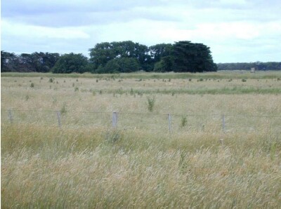
The soils are variable throughout this land unit due to varying depositional environments. A common soil type is a strong texture contrast soil (Chromosol) commonly with a bleached A2 horizon and a mottled subsoil (indicative of impeded internal drainage). The sandy topsoil can be very deep in some soils. Vertosols are also common on the plains and swales in between the dunes. Podosols occur on the flats as well as on the dunes and that may have been mapped as part of this land unit due to restrictions of scale. Many of the soils are poorly drained and exhibit signs of a perched watertable. This site has a 1.5 year old Eucalyptus globulus plantation on ex-agricultural land. The site is probably a heathland/bog. The trees in this plot have been severely affected by waterlogging. |
Site Description:
| Geology: Quaternary lacustrine | Landform pattern: Plain |
| Position in landscape: Flat | Internal drainage: Poorly drained |
Soil Profile Morphology
| A1 | 0-20 cm | Black (10YR2/1) light clay; weak angular blocky structure (50-100 mm); firm consistence when dry; few medium ferruginous nodules; many fine macropores; areal porosity 0.6%; common medium roots; clear and smooth transition to: | 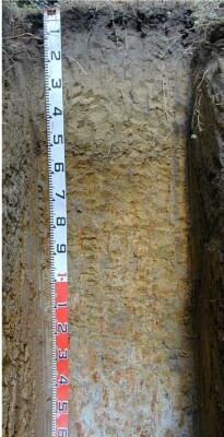 |
| Subsoil | |||
| Bs | 20 – 40 cm | Black (10YR2/1) light clay; unable to assess structure, consistence or macroporosity due to the presence of very many segregations; very many coarse ferruginous nodules; dry; few fine roots; clear and smooth transition to: | |
| B21 | 40 – 75 cm | Brownish yellow (10YR6/6), medium clay; moderate subangular blocky structure (50-100 mm) parting to strong subangular blocky structure (10-20 mm); weak consistence when moderately moist; common coarse ferruginous nodules; common very fine macropores; areal porosity 0.05%; no roots observed; gradual and smooth transition to: | |
| B22 | 75 – 120 cm | Light grey (10YR7/1) with many coarse distinct brownish yellow (10YR6/7) mottles, medium clay; moderate subangular blocky structure (50-100 mm) parting to moderate subangular blocky structure (10-20 mm); weak consistence when moderately moist; common coarse ferruginous nodules; common very fine macropores; areal porosity 0.05%; no roots observed; gradual and smooth transition to: | |
| B23 | 120 – 150 cm | Grey (5YR6/1) with many coarse prominent yellowish brown (10YR5/8) mottles, medium heavy clay; moderate subangular blocky structure (50-100 mm) parting to moderate subangular blocky structure (10-20 mm); weak consistence when moist; common very fine macropores; areal porosity 0.05%; no roots observed. | |
| 150 – 170 cm | Similar to layer above. | ||
| 170 – 350 cm | Grey and yellow clays, many large (60-200 mm) limestone fragments, limestone appears to be solid at about 350 cm, with water on top of the limestone. | ||
Notes: Sampled by: Ian Sargeant and Paul Feikema (13 December 2000)
© State of Victoria (Agriculture Victoria) 1996 - .

This work, Victorian Resources Online, is licensed under a Creative Commons Attribution 4.0 licence. You are free to re-use the work under that licence, on the condition that you credit the State of Victoria (Agriculture Victoria) as author, indicate if changes were made and comply with the other licence terms.
The licence does not apply to ‘branding’ or some ‘images or photographs’ that may be owned by third parties. We ask you to seek prior approval to use images using the VRO feedback form. Access to higher quality images can also be provided on request.
This page was last updated on .