
CHA99 (Plot1)
| Site: CHA99 (Plot 1) | Land Unit: Grampians Alluvial |
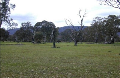 |
General Land Unit Description: This land unit consists of the alluvial plains around the Grampians. The soils are commonly poorly drained Grey Sodosols in association with Podosols. Some areas experience months of inundation. These soils are commonly Hydrosols. The vegetation is mainly thick scrubby tea tree on the wetter soils. This site is near the base of the Grampians, and it appears that water drains onto the alluvial plains from the Grampians. Apparently groundwater closer to the Grampians (about 1 km to the east) is at a depth of 3 m. Currently there exists a 1.5 year old E. globulus plantation on ex-agricultural land. |
Site Description:
| Geology: Quaternary alluvial | Landform pattern: Plain |
| Position in landscape: Flat | Internal drainage: Poorly drained |
Soil Profile Morphology
| A1 | 0-30 cm | Dark grey (10YR4/1) loamy sand, single grain structure, loose consistence when moist, many medium roots. Gradual and smooth transition to: | 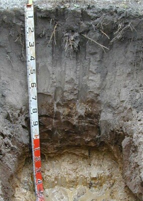 |
| A2 | 30-70 cm | Light grey (10YR7/2) sand, single grain structure, loose consistence when moist, few very fine roots. Gradual and smooth transition to: | |
| Subsoil | |||
| Bh | 70-115 cm | Very dark brown (10YR2/2) with few medium distinct pale brown (10YR6/3) mottles, loamy sand, single grain structure, very weak consistence when wet, few medium ferruginous nodules, common very fine macropores, areal porosity 0.4%, few very fine roots. Gradual and smooth transition to: | |
| B2 | 115-130 cm | Very pale brown (10YR7/4) sand, single grain structure, loose consistence when wet, unable to estimate macroporosity, few very fine roots. Sharp and smooth transition to: | |
| C | 130-150 cm | Light grey (10YR7/1) with many coarse prominent yellow (10YR7/6) mottles, sandy clay, weak polyhedral structure (20-50 mm), firm consistence when moist, few very fine macropores, areal porosity 0.1%, no roots observed. | |
| 150-400 cm | Sandy clay to 300 cm, then grey mottled clayey sand mixed with heavy clay and sand, coarse quartz fragments observed below 300 cm. | ||
Notes: The Mudstone layer does not appear to offer a large water holding capacity.
© State of Victoria (Agriculture Victoria) 1996 - .

This work, Victorian Resources Online, is licensed under a Creative Commons Attribution 4.0 licence. You are free to re-use the work under that licence, on the condition that you credit the State of Victoria (Agriculture Victoria) as author, indicate if changes were made and comply with the other licence terms.
The licence does not apply to ‘branding’ or some ‘images or photographs’ that may be owned by third parties. We ask you to seek prior approval to use images using the VRO feedback form. Access to higher quality images can also be provided on request.
This page was last updated on .