
SM01
Location: Buckley Swamp
Australian Soil Classification: Melacic-Mottled (& Vertic), Eutrophic, Brown CHROMOSOL
General Landscape Description: Undulating lava plain adjacent to Buckley Swamp.
Site Description: Mid slope.
Land Use: Grazing.
Geology: Basalt.
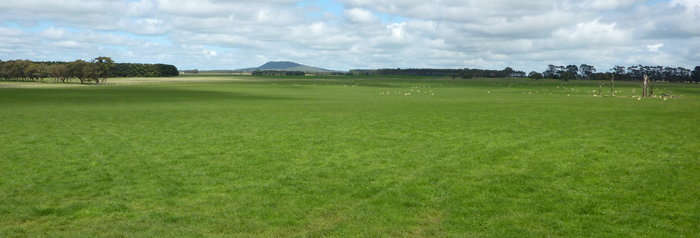
SM01 Landscape - pit in the foreground.
Soil Profile Morphology:
| Surface Soil | 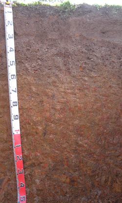 SM01 profile | ||
| A11 | 0-13 cm | Very dark greyish brown (10YR3/2); firm surface condition; light clay loam (fine sandy); strong medium polyhedral, parting to very fine polyhedral structure; rough fabric; weak consistence moderately moist; many fine roots present; pH 5.1; clear change to: | |
| A12 | 13-30 cm | Very dark greyish brown (10YR3/2); clay loam; moderate medium polyhedral, parting to very fine polyhedral structure; rough fabric; very weak consistence moist; contains very few ferro-manganiferous nodules; many fine roots present; pH 5.1; clear change to: | |
| A2 | 30-55 cm | Brown (7.5YR4/3); clay loam; weak coarse polyhedral, parting to fine polyhedral structure; rough fabric; weak consistence moderately moist; gravelly ferro-manganiferous nodules abundant; fine roots common; pH 6.1; clear change to: | |
| Subsoil | |||
| B21 | 55-80 cm | Yellowish brown (10YR5/4) with faint dark red (2.5YR4/8) mottles common; medium clay; moderate medium prismatic, parting to very fine polyhedral structure; smooth fabric; weak consistence moist; gravelly ferro-manganiferous nodules common; very fine roots common; pH 6.6; diffuse change to: | |
| B22 | 80-130 cm | Dark yellowish brown (10YR4/6) with many coarse distinct dark yellowish brown (10YR4/4) and dark red (2.5YR4/8) mottles; medium clay; moderate coarse lenticular, parting to fine angular blocky structure; smooth fabric; weak consistence moist; faint slickensides common with few distinct organo-clay cutans evident; very few very fine roots present; pH 6.4; clear change to: | |
| BC | 130-150+ cm | Greyish brown (10YR5/2) with many very coarse prominent dark red (2.5YR4/6) and light grey (5Y7/1) mottles; medium heavy clay; moderate coarse lenticular, parting to moderate angular blocky structure; smooth fabric; firm consistence moist; many distinct slickensides evident; contains few very weathered basalt fragments; very few very fine roots present; pH 6.6. | |
Soil Profile Characteristics:
pH | Salinity Rating | |||
Surface (A1 horizon) | Strongly Acid | Very Low | Non Sodic | None |
Subsoil (B21 horizon) | Slightly Acid | Very Low | Non Sodic | None |
Deeper Subsoil (at 80-130+ cm) | Slightly Acid | Very Low | Sodic | None |
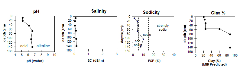
| The surface soil is strongly acid. The subsoil is slightly acid. | The salinity rating is very low throughout the profile.
| The surface and the upper subsoil are non-sodic. The deeper subsoil is sodic. | The MIR predicted clay content increases markedly at the A / B boundary. |
Horizon | Horizon Depth (cm) | pH (water) | pH (CaCl2) | EC dS/m | Total Carbon g/100g | Exchangeable Aluminium mg/kg | Exchangeable Acidity meq/100g | Exchangeable Cations | |||
Ca | Mg | K | Na | ||||||||
meq/100g | |||||||||||
A11 | 0 – 13 | 5.1 | 4.3 | 0.09 | 4.2 | 64 | 15 | 3.4 | 1.3 | 0.22 | 0.26 |
A12 | 13 - 30 | 5.1 | 4.2 | 0.05 | 2.6 | 0.9 | 0.15 | 0.16 | |||
A2 | 30 -55 | 6.1 | 5.2 | 0.05 | 2.9 | 1.3 | 0.08 | 0.22 | |||
B21 | 55 - 80 | 6.6 | 5.7 | 0.10 | 11 | 4.6 | 5.9 | 0.14 | 0.98 | ||
B22 | 80 - 130 | 6.4 | 5.8 | 0.13 | 4.3 | 7.7 | 0.15 | 1.4 | |||
B23 | 130 - 150+ | 6.6 | 5.8 | 0.14 | 9.9 | 4.4 | 11 | 0.11 | 2.1 | ||
Horizon | Horizon Depth (cm) | Field Capacity pF2.5 (MIR Predicted) | Wilting Point pF4.2 (MIR Predicted) | Coarse Sand (0.2-2.0mm) (MIR Predicted) | Fine Sand (0.02-0.2mm) (MIR Predicted) | Silt (0.002-0.02mm) (MIR Predicted) | Clay (<0.002mm) (MIR Predicted) |
A11 | 0 – 13 | 28.9 | 12.0 | 11 | 34 | 22 | 20 |
A12 | 13 - 30 | 25.6 | 12.4 | 9 | 31 | 24 | 23 |
A2 | 30 -55 | 23.8 | 12.4 | 11 | 32 | 19 | 25 |
B21 | 55 - 80 | 37.3 | 23.6 | 7 | 16 | 12 | 60 |
B22 | 80 - 130 | 48.6 | 33.8 | 3 | 6 | 11 | 87 |
B23 | 130 - 150+ | 50.5 | 36.2 | 3 | 6 | 14 | 87 |
Profile Described By: David Rees and Ivanah Oliver (September 2014).
© State of Victoria (Agriculture Victoria) 1996 - .

This work, Victorian Resources Online, is licensed under a Creative Commons Attribution 4.0 licence. You are free to re-use the work under that licence, on the condition that you credit the State of Victoria (Agriculture Victoria) as author, indicate if changes were made and comply with the other licence terms.
The licence does not apply to ‘branding’ or some ‘images or photographs’ that may be owned by third parties. We ask you to seek prior approval to use images using the VRO feedback form. Access to higher quality images can also be provided on request.
This page was last updated on .