
SFS9a
Location: Woodhouse
Australian Soil Classification: Vertic (& Ferric), Mottled-Subnatric, Grey SODOSOL
Northcote Factual Key: Dy3.42
General Landscape Description: Level plain within the Victorian volcanic plains. Flat, gently sloping on the side of broad depression.
Site Description: Depression or 'hollow' component of gilgai micro-relief.
Land Use: Raised beds with canola.
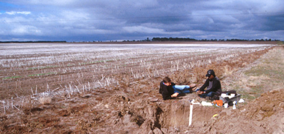 SFS9a Landscape |
Soil Profile Morphology:
| Surface Soil | 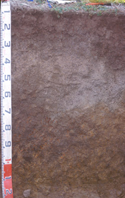 SFS9a Profile | ||
| A1 | 0-8/10 cm | Dark greyish brown (10YR4/2) with rusty root channel mottling; loam; apedal; weak consistence dry; pH 5; clear and wavy change to: | |
| A2 | 8/10-60 cm | Brown (10YR5/3) with conspicuous bleach (10YR6/2d) and yellow mottles; clay loam, fine sandy; lower part of horizon (40-60 cm depth) has abundant (~90%) buckshot; pH 5.8; clear and abrupt change to: | |
| Subsoil | |||
| B21tc | 60-100 cm | Dark grey (10YR4/1) with common brownish yellow (10YR6/8) and dark red (2.5YR4/8) mottles; heavy clay; common (10-20%) buckshot; friable in a moist condition; fine polyhedral and lenticular structure; pH 7.0; gradual change to: | |
| B22 | 100+ cm | Dark grey (10YR4/1) with many brownish yellow (10YR6/8) mottles and very few dark red (2.5YR4/8) mottles disappearing at depth; medium heavy clay; fine polyhedral and lenticular structure; pH 6.8. | |
Key Profile Features:
- Strong texture contrast between surface (A) horizon and subsoil (B21) horizon.
- Conspicuously bleached subsurface (A2) horizon.
- Buckshot in A2 is only in lower 10cm of horizon.
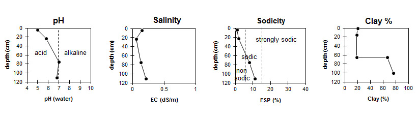
Soil Profile Characteristics:
pH | Salinity Rating | |||
Surface (A1 horizon) | Strongly Acid | Low | Non-Sodic | None |
Subsoil (B21 horizon) | Neutral | Very Low | Sodic | None1 |
Deeper Subsoil (B22 horizon) | Slightly Acid | Low | Sodic | None |
Horizon | Horizon Depth (cm) | pH (water) | pH (CaCl2) | EC dS/m | Organic Carbon % | Nitrogen % | Exchangeable Cations | |||
Ca | Mg | K | Na | |||||||
meq/100g | ||||||||||
A1 | 0-8/10 | 5 | 4.4 | 0.15 | 4.3 | 0.36 | 4.2 | 1.6 | 0.22 | 0.35 |
A2 | 15-30 | 5.8 | 4.9 | 0.06 | 3.2 | 1.4 | 0.08 | 0.25 | ||
B21k | 65-85 | 7 | 7 | 0.13 | 4 | 9.1 | 0.25 | 2.2 | ||
B22 | 100+ | 6.8 | 6.5 | 0.21 | 4.5 | 11 | 0.27 | 3.3 | ||
Horizon | Horizon Depth (cm) | Exchangeable Aluminium mg/kg | Exchangeable Acidity meq/100g | Field Capacity pF2.5 | Wilting Point pF4.2 | Coarse Sand (0.2-2.0 mm) | Fine Sand (0.02-0.2 mm) | Silt (0.002-0.02 mm) | Clay (<0.002 mm) |
A1 | 0-8/10 | 37 | 14 | 34.6 | 12.1 | 5 | 39 | 28 | 20 |
A2 | 15-30 | <10 | 6.7 | 30.1 | 7.6 | 3 | 43 | 32 | 19 |
B21k | 65-85 | 12 | 40.7 | 26.7 | 9 | 12 | 8 | 67 | |
B22 | 100+ | 11 | 45.4 | 29.8 | 3 | 10 | 8 | 76 |
Management Considerations:
Whole Profile
- Plant available water capacity (PAWC) is considered to be medium (estimated at 107 mm) in the upper 100 cm of this soil profile.
- This site had more earthworms than has been seen at any other SFS site.
© State of Victoria (Agriculture Victoria) 1996 - .

This work, Victorian Resources Online, is licensed under a Creative Commons Attribution 4.0 licence. You are free to re-use the work under that licence, on the condition that you credit the State of Victoria (Agriculture Victoria) as author, indicate if changes were made and comply with the other licence terms.
The licence does not apply to ‘branding’ or some ‘images or photographs’ that may be owned by third parties. We ask you to seek prior approval to use images using the VRO feedback form. Access to higher quality images can also be provided on request.
This page was last updated on .