
SFS11
Location: Streatham
Australian Soil Classification: Vertic (& Eutrophic), Mottled-Mesonatric, Grey SODOSOL
Northcote Factual Key: Duplex
Landscape Description: Level plain?
Site Description: Flat to very gently sloping simple slope, convex.
Land Use: Canola cropping. In 1998 there were raised beds.
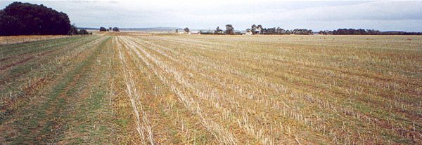 SFS11 Landscape. |
Soil Profile Morphology:
Surface Soil
| Ap | 0-10 cm | Brown (10YR4/3); sandy clay loam; apedal to very weakly pedal; weak consistence dry; pH 6.0; clear change to: | 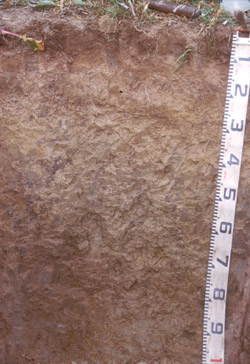 SFS11 Profile. | |
| A2 | 10-25/30 cm | Brown (10YR5/3), conspicuously bleached (10YR7/4d); sandy clay loam; apedal; many fine and medium macropores; firm consistence dry; few fine to medium buckshot (some magnetic), sporadic patches of buckshot that are >50%; pH 5.2; abrupt change to: | ||
| Subsoil | ||||
| B21gt | 25/30-80 cm | Light olive brown (2.5Y5/4) very gleyed, with distinct fine yellow (2.5Y8/8) and dark red (2.5YR3/6) mottles and some darker coatings on ped faces; heavy clay; pedal; some pockets of coarse prismatic structure; very strong consistence dry; common buckshot; many fine pores; pH 7.1 to 8.3 at depth; gradual change to: | ||
| B22k | 80+ cm | Light olive brown (2.5Y5/3) gley; medium heavy clay; fine polyhedral to lenticular structure; small slickensides; very few buckshot; very few fine hard calcium carbonate concretions; slightly calcareous; pH 9.0. | ||
Subsoil (on other side of pit - less gleyed, more structure) | ||||
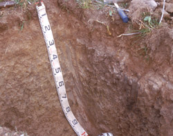 SFS11 Other pit face - shows prismatic structure in the B21. | ||||
| B21tg | 25/30-80 cm | Very dark grey (10YR3/1) with many faint light olive brown (2.5Y5/3) mottles; heavy clay; very coarse prismatic tending to columnar, parting to coarse prismatic, parting to very fine polyhedral structure; very few buckshot; many fine pores; pH ???; gradual change to: | ||
Key Profile Features:
- Strong texture contrast between surface (A) horizons and subsoil (B21) horizon.
- Conspicuously bleached subsurface (A2) horizon.
Soil Profile Characteristics:
pH | Salinity Rating | |||
Surface (A1 horizon) | Moderately Acid | Low-Medium | Non-Sodic | None |
Subsoil (B21 horizon) | Near Neutral | Very Low | Sodic | None1 |
Deeper subsoil (at 80 cm) | Strongly Alkaline | Low | Strongly Sodic | Strong-Complete |
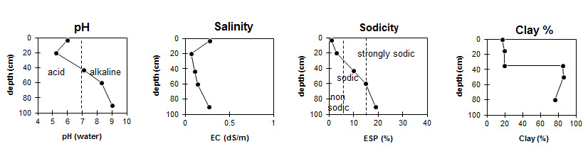
Horizon | Horizon Depth (cm) | pH (water) | pH (CaCl2) | EC dS/m | NaCl % | Organic Carbon % | Total Nitrogen % | Exchangeable Aluminium ppm | Exchangeable Acididty meq/100g | Exchangeable Cations | Coarse Sand (0.2-2.0 mm) % | Fine Sand (0.02-0.2 mm) % | Silt (0.002-0.02 mm) % | Clay (<0.002 mm) % | Field Capacity % w/w | Wilting Point % w/w | |||
Ca | Mg | K | Na | ||||||||||||||||
meq/100g | |||||||||||||||||||
Ap | 0-5 | 6 | 5.5 | 0.28 | 0.03 | 2.5 | 0.11 | <10 | 7.9 | 4.4 | 0.9 | 1.1 | <0.1 | 14 | 40 | 22 | 17 | 26.2 | 9.1 |
A2 | 15-25 | 5.2 | 4.3 | 0.07 | 62 | 6.9 | 1.3 | 0.61 | 0.42 | 0.24 | 12 | 42 | 28 | 20 | 24.6 | 7.1 | |||
B21gt (higher) | 35-50 | 7.1 | 5.7 | 0.11 | 12 | 5.9 | 11 | 1.8 | 3.3 | 2 | 5 | 3 | 85 | 49.3 | 30.7 | ||||
B21gt (lower) | 50-70 | 8.3 | 8.3 | 0.14 | 6.9 | 5.6 | 14 | 2.1 | 5 | 1 | 6 | 3 | 86 | 58.8 | 31.4 | ||||
B22 | 80+ | 9 | 8.1 | 0.27 | <0.01 | 2.9 | 5.8 | 15 | 2.1 | 6.2 | 2 | 10 | 6 | 76 | 51.8 | 30.3 | |||
Management Considerations:
Whole Profile
- Plant available water capacity (PAWC) is considered to be medium (estimated at 121 mm) in the upper 70 cm of this soil profile. Effective rooting depth (ERD) is restricted to 70 cm due to the highly sodic subsoils (ESP>20).
Profile Described By: Richard MacEwan (May 1999).
© State of Victoria (Agriculture Victoria) 1996 - .

This work, Victorian Resources Online, is licensed under a Creative Commons Attribution 4.0 licence. You are free to re-use the work under that licence, on the condition that you credit the State of Victoria (Agriculture Victoria) as author, indicate if changes were made and comply with the other licence terms.
The licence does not apply to ‘branding’ or some ‘images or photographs’ that may be owned by third parties. We ask you to seek prior approval to use images using the VRO feedback form. Access to higher quality images can also be provided on request.
This page was last updated on .