
LSWW19
Location: South of Edenhope
General Landscape Description: Plain
Site Description: Plain
Geology: Quaternary swamp and lake deposits: paludal silt and clay
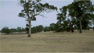
Red gum plains south of Edenhope
| A1 | 0–10 | Very dark greyish brown (10YR3/2); sandy loam; moderate coarse subangular blocky, parting to subangular blocky structure; firm consistence when dry; very few subrounded ferruginous nodules; pH 6.0; abrupt boundary to: | 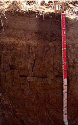 Ferric (and Calcic), Mottled-Mesonatric, Brown Sodosol |
| A21 | 10–30 | Dark greyish brown (10YR4/2) with few orange mottles; loamy sand; sporadically bleached; massive (structureless); very firm consistence when dry; very few ferruginous nodules; pH 6.4; abrupt and wavy boundary to: | |
| A22p | 30–45 | Uncemented discontinuous nodular ferricrete and manganiferous pan; pH 6.8. | |
| A23 | 45–50 | Yellowish brown (10YR5/4); clayey sand; conspicuously bleached; massive (structureless); weak to very weak consistence when dry; abundant (70%) ferruginous and manganese nodules; pH 6.8; abrupt boundary to: | |
| Subsoil | |||
| B21 | 50–75 | Light olive brown (2.5Y5/3) with common faint yellow and distinct red mottles; heavy clay; strong very coarse polyhedral, parting to strong coarse polyhedral structure; very strong consistence when dry; few manganese nodules and flecks; pH 6.8; diffuse transition to: | |
| B22 | 75–120 | Brownish yellow (10YR6/6); heavy clay; strong very coarse prismatic, parting to strong coarse polyhedral structure; dispersive when worked; pH 8.0; diffuse boundary to: | |
| B23 | 120–170+ | Brownish yellow (10YR6/6) with red mottling common in patches, other mottling is associated with ferruginised sandstone; heavy clay; strong very coarse prismatic, parting to strong coarse polyhedral structure; pH 8.8. |
Soil Profile Characteristics:
- | pH | Salinity | |
Surface Soil (A1 horizon) | Moderately Acid | Very Low | Sodic |
Subsoil (50-75 cm) | Slightly Acid | Very Low | Strongly Sodic |
Deeper Subsoil (120-170 cm) | Strongly Alkaline | Low | - |
Chemical and Physical Analysis:
Horizon | Horizon Depth (cm) | pH (water) | pH (CaCl2) | EC dS/m | Exchangeable Cations | Coarse Sand (0.2-2.0 mm) % | Fine Sand (0.02-0.2 mm) % | Silt (0.002-0.02 mm) % | Clay (<0.002 mm) % | Wilting Point % w/w | |||
Ca | Mg | K | Na | ||||||||||
meq/100g | |||||||||||||
A1 | 0–10 | 6.0 | 4.9 | <0.05 | 2 | 1.2 | 0.4 | 0.3 | 31.6 | 39.9 | 11.5 | 13 | 6.7 |
A21 | 10–30 | 6.4 | 5.0 | <0.05 | 1 | 0.4 | 0.1 | 0.1 | 32.9 | 46.6 | 11 | 8 | 2.8 |
A22p | 30–45 | 6.8 | 6.1 | <0.05 | |||||||||
A23 | 45–50 | 6.8 | 5.4 | <0.05 | 1.2 | 1.1 | 0.1 | 0.3 | 32.8 | 41.6 | 10.5 | 14 | 5.2 |
B21 | 50–75 | 6.8 | 5.5 | 0.06 | 6.2 | 8.5 | 0.4 | 2.8 | 5.6 | 6.8 | 2 | 79 | 28.7 |
B22 | 75–120 | 8.0 | 7.0 | 0.18 | 6.9 | 11 | 0.3 | 4 | |||||
B23 | 120–170+ | 8.8 | 7.9 | 0.29 | |||||||||
Management Considerations:
- Strong texture contrast between surface (top)soil and subsoil
- Acid surface soil, susceptible to sheet and rill erosion
- Bleached A2 horizon, low nutrient levels, including a Ferric ‘ironstone’ pan
- Subsoil is neutral becoming alkaline and sodic becoming strongly sodic with depth
- Mottled subsoil
- Plant Available Water Capacity (PAWC) is considered to be high (estimated at 150 mm) for this site profile based on an Effective Rooting Depth (ERD) of 75 cm. Rooting depth will be restricted by subsoil conditions, such as; strongly sodic (Exchangeable Sodium Percentage >20%), high soluble salt levels (chloride >0.1%), poor structure (e.g. massive or very coarse, columnar or prismatic), very high carbonate (lime) content (not applicable to all plant species) or hard rock.
© State of Victoria (Agriculture Victoria) 1996 - .

This work, Victorian Resources Online, is licensed under a Creative Commons Attribution 4.0 licence. You are free to re-use the work under that licence, on the condition that you credit the State of Victoria (Agriculture Victoria) as author, indicate if changes were made and comply with the other licence terms.
The licence does not apply to ‘branding’ or some ‘images or photographs’ that may be owned by third parties. We ask you to seek prior approval to use images using the VRO feedback form. Access to higher quality images can also be provided on request.
This page was last updated on .