
LP65
Location: Lexton
Australian Soil Classification: Vertic (and Calcic), Mottled-Mesonatric, Black SODOSOL
Great Soil Group: solodic
General Landscape Description: Lower-midslope position of a gently undulating plain landscape just east of Whitestone Swamp. The soil on this site has probably developed on former swamp deposits. Original vegetation included River Red Gum (Eucalyptus camaldulensis).
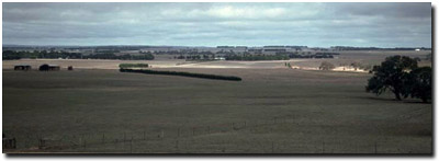 LP65 Landscape |
Soil Profile Morphology:
| Surface Soil | 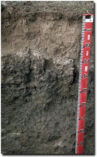 LP65 Profile | ||
| A11 | 0-25 cm | Dark brown (10YR3/3); light very fine sandy loam; weakly structured; firm consistence moist; pH 5.3; clear change to: | |
| A12 | 25-30 cm | Brown (10YR4/3); fine sandy clay loam; firm consistence moist; contains few (5%) ferromanganiferous nodules (3-8 mm size); rusty root channel mottling present; pH 6.1; sharp change to: | |
| Subsoil | |||
| B21 | 30-55 cm | Dark grey (10YR3/1) with yellowish brown (10YR5/8) mottles; heavy clay; moderate coarse blocky structure; strong consistence moist; pH 7.2; clear change to: | |
| B22 | 55-80 cm | Greyish brown (10YR5/2) with a yellowish brown (10YR7/6) diffusely mottles; medium heavy clay; very firm consistence moist; contains very few (2%) ferro-manganiferous nodules; pH 8.2; clear change to: | |
| B23k | 80-100 cm | Greyish brown (10YR5/2); medium heavy clay; very firm consistence moist; contains few (2-5%) fine-earth carbonates and very few (2%) hard carbonates; slickensides present from 70 cm; pH 8.9; abrupt change to: | |
| B3 | 100 + cm | Dark greyish brown (10YR4/2); sandy clay loam; very firm consistence moist; contains a few (5%) manganese flecks in patches; pH 8.9. | |
Key Profile Features:
- Strong texture contrast between surface (A) horizons (27% clay) and the subsoil (B21) horizon (61% clay).
- Vertic properties at depth in the subsoil (i.e. slickensides, cracking).
- Variable depth of surface horizon (can vary between 10-40 cm).
- Conspicuously bleached surface (A21) horizon.
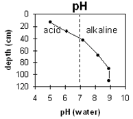
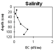
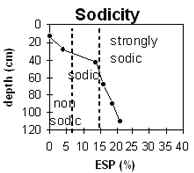
pH | Salinity Rating | |||
Surface (A1 horizon) | Strongly Acid | Low | - | None1 |
Subsoil (B21 horizon) | Slightly Alkaline | Very Low | Strongly Sodic | Strong2 |
Deeper subsoil (at 1 m) | Strongly Alkaline | Low-Medium | Strongly Sodic | None3 |
 |  |  |
Horizon | Horizon Depth cm | pH (water) | pH CaCl2 | EC dS/m | Sodium Chloride % | Exchangeable Cations | Exchangeable Aluminium mg/kg | Field Capacity pF2.5 | Wilting Point pF4.2 | Coarse Sand (0.2-2.0mm) | Fine Sand (0.02-0.2mm) | Silt (0.002-0.02mm) | Clay (<0.002mm) | |||
Ca | Mg | K | Na | |||||||||||||
meq/100g | ||||||||||||||||
A1 | 0-25 | 5 | 4.4 | 0.12 | 4.6 | 3 | 0.4 | 0.1 | 58 | 26 | 14.9 | 12 | 41 | 17 | 27 | |
A2 | 25-30 | 6.1 | 4.9 | 0.06 | 2.2 | 2.1 | 0.3 | 0.3 | ||||||||
B21 | 30-55 | 7.2 | 6.2 | 0.18 | 6.6 | 11 | 0.9 | 3.1 | 48.2 | 31.3 | 7 | 19 | 9 | 61 | ||
B22 | 55-80 | 8.2 | 7.2 | 0.33 | <0.05 | 8.5 | 19 | 0.9 | 5.3 | |||||||
B23 | 80-100 | 8.9 | 8.3 | 0.7 | 0.08 | 8.4 | 19 | 0.9 | 6.6 | |||||||
B3 | 100+ | 8.9 | 8.1 | 0.5 | 0.07 | 8.8 | 19 | 0.9 | 7.5 | |||||||
Management Considerations:
Whole Profile
- Plant available water capacity (PAWC) is estimated to be relatively low (estimated at 75 mm). This is based on available laboratory data and assumes an effective rooting depth of 50 cm. Effective rooting depth will be restricted by the strongly sodic and dispersive subsoil. In areas where the A1 horizon is deeper, PAWC will be higher. The low PAWC will limit pasture growth into a dry spring and summer.
- The strongly acid surface soil suggests that aluminium and manganese toxicity may occur. Deficiencies in molybdenum, calcium, magnesium and potassium may also occur. The exchangeable aluminium level measured in the laboratory (58 ug/g) indicates that the growth of highly sensitive species (e.g. lucerne, barley, medics) may be affected. Raising the pH levels of the surface soil will help reduce the effects of toxicity. Lime can be used to increase soil pH but it should be noted that a pH/aluminium test is best performed from samples taken across the paddock and bulked together. Other factors also need to be considered before lime is recommended (e.g. pasture species grown, method of application, local trial responses, soil surface structure and likely cost/benefit).
- The surface disperses slightly after remoulding. Over-stocking or excessive cultivation of the soil when wet may result in surface sealing and exacerbate the hardsetting condition.
- Organic carbon and nitrogen levels are reasonable for the surface horizon. Maintaining organic matter levels is important on soils that are high in fine sand and silt, in order to assist in aggregate stabilisation.
- The variable depth of the surface horizon will probably reflect in variations in plant growth across the paddock.
- The dense and coarsely structured subsoil is strongly sodic and disperses strongly. This will result in restricted root and water movement throughout the profile.
- The deeper subsoil (at 80 cm depth) has a low-medium salinity rating which may restrict the growth of some deeper rooted salt sensitive species.
- The subsoil becomes strongly alkaline at 80 cm depth, suggesting that some nutrients (eg. phosphorus, iron, manganese and zinc) may be poorly available to some deeper rooted species, e.g. lucerne.
- At depth, the subsoil is vertic and will display significant shrinking and swelling upon wetting and drying. This has implications for engineering purposes (e.g. building foundations).
© State of Victoria (Agriculture Victoria) 1996 - .

This work, Victorian Resources Online, is licensed under a Creative Commons Attribution 4.0 licence. You are free to re-use the work under that licence, on the condition that you credit the State of Victoria (Agriculture Victoria) as author, indicate if changes were made and comply with the other licence terms.
The licence does not apply to ‘branding’ or some ‘images or photographs’ that may be owned by third parties. We ask you to seek prior approval to use images using the VRO feedback form. Access to higher quality images can also be provided on request.
This page was last updated on .