
GL7
Location: Warrock
Australian Soil Classification: Mottled, ?, Brown CHROMOSOL (confidence level 3)
General Landscape Description: Undulating rises
Site Description: Lower slope
Land Unit: Dissected Slates.
Geology: Cambrian schists
General Land Unit Description: This land unit covers a small area of dissected slopes leading to the Glenelg River and its tributaries, as well as a small area adjacent to Rocklands Reservoir. The most common landform is undulating rises, although there are some gentler slopes coming off the rises. There is also a small patch of low hills that have not been mapped due to restrictions of scale. This area would have a lower capability for land use options due to slope, soil and rock outcrop restrictions.
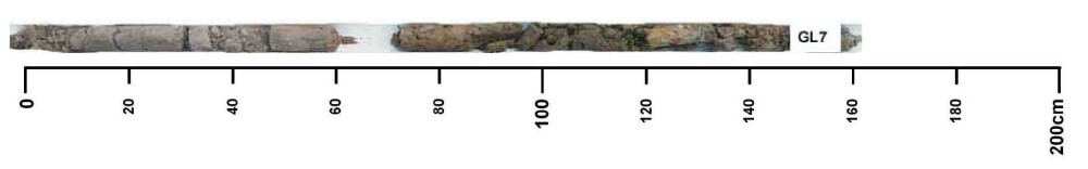
Soil Profile Morphology
| A11 | 0-10 cm | Very dark brown (10YR2/2); loamy sand; fine to very fine subangular blocky structure; weak consistence, dry; pH 6.0; changes to: |
| A12 | 10-30 cm | Very dark grey (10YR3/1); loamy sand; massive structure; firm consistence, dry; pH 6.0; changes to: |
| Subsoil | ||
| B21 | 60-70 cm | Brown (10YR4/3), with many faint orange and yellow mottles; light clay; moderate to weak fine subangular blocky structure; very firm consistence, dry; contains many medium rounded to ferruginous nodules; pH 7.0; changes to: |
| B22 | 70-120 cm | Light olive brown (2.5Y5/4), with many distinct orange and yellow mottles; medium heavy clay; moderate subangular blocky structure; pH 6.5; changes to: |
| BC | 120-150+ cm | Grey, with many prominent orange and red mottles; medium heavy clay. |
Profile Described By: Natalie Baxter and Grant Boyle, 1st October 2000.
© State of Victoria (Agriculture Victoria) 1996 - .

This work, Victorian Resources Online, is licensed under a Creative Commons Attribution 4.0 licence. You are free to re-use the work under that licence, on the condition that you credit the State of Victoria (Agriculture Victoria) as author, indicate if changes were made and comply with the other licence terms.
The licence does not apply to ‘branding’ or some ‘images or photographs’ that may be owned by third parties. We ask you to seek prior approval to use images using the VRO feedback form. Access to higher quality images can also be provided on request.
This page was last updated on .